
China is a country located in East Asia with an area of 9,596,960 km2 (3,705,410 sq mi). The exact land area can sometimes be challenged by border disputes, including those concerning Taiwan, Aksai Chin, the Trans-Karakoram Tract, the South China Sea Islands, the Senkaku Islands, and South Tibet. As sovereignty over Hong Kong and Macau were restored to China in 1997 and 1999, two special administrative regions were established under the One Country, Two Systems policy. The People's Republic of China is either the third or fourth largest country in the world, being either slightly larger or slightly smaller than the United States depending on how the area of the United States is measured.
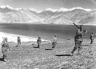
The Sino-Indian War between China and India occurred in October–November 1962. A disputed Himalayan border was the main cause of the war. There had been a series of violent border skirmishes between the two countries after the 1959 Tibetan uprising, when India granted asylum to the Dalai Lama. India initiated a defensive Forward Policy from 1960 to hinder Chinese military patrols and logistics, in which it placed outposts along the border, including several north of the McMahon Line, the eastern portion of the Line of Actual Control proclaimed by Chinese Premier Zhou Enlai in 1959.

Bhutan has diplomatic relations with 54 of 193 member states of the United Nations, including the European Union. Bhutan's limited number of such relations, including the absence of formal relations with any of the permanent members of the United Nations Security Council, is part of a deliberate isolationist policy of limiting foreign influence in the state. This stance has been safeguarded by close relations with India, of which Bhutan has previously been considered a protected state.

The McMahon Line is the boundary between Tibet and British India as agreed in the maps and notes exchanged by the respective plenipotentiaries on 24-25 March 1914 at Delhi, as part of the 1914 Simla Convention. The Republic of China was not a party to the McMahon Line agreement, but the line was part of the overall boundary of Tibet defined in the Simla Convention, initialled by all three parties and quickly repudiated by the government of China. The Indian part of the Line currently serves as the de facto boundary between China and India, although its legal status is disputed by the People's Republic of China. The Burmese part of the Line was renegotiated by the People's Republic of China and Myanmar.

China–India relations, also called Sino-Indian relations or Indo–Chinese relations, refers to the bilateral relationship between China and India. China and India had historically peaceful relations for thousands of years of recorded history. But the tone of the relationship has varied in modern time, especially after the rule of Communist Party in China; the two nations have sought economic cooperation with each other, while frequent border disputes and economic nationalism in both countries are a major point of contention. The modern relationship began in 1950 when India was among the first countries to end formal ties with the Republic of China (Taiwan) and recognise the People's Republic of China as the legitimate government of Mainland China. China and India are two of the major regional powers in Asia, and are the two most populous countries and among the fastest growing major economies in the world. Growth in diplomatic and economic influence has increased the significance of their bilateral relationship.

The Sino-Indian border dispute is an ongoing territorial dispute over the sovereignty of two relatively large, and several smaller, separated pieces of territory between China and India. The first of the territories, Aksai Chin, is administered by China as part of the Xinjiang Uygur Autonomous Region and Tibet Autonomous Region and claimed by India as part of the union territory of Ladakh; it is the most uninhabited high-altitude wasteland in the larger regions of Kashmir and Tibet and is crossed by the Xinjiang-Tibet Highway, but with some significant pasture lands at the margins. The other disputed territory is south of the McMahon Line, formerly known as the North-East Frontier Agency and now called Arunachal Pradesh. The McMahon Line was part of the 1914 Simla Convention signed between British India and Tibet, without China's agreement. China disowns the agreement, stating that Tibet was never independent when it signed the Simla Convention.

The Kingdom of Bhutan and the People's Republic of China do not maintain official diplomatic relations, and relations are historically tense. The PRC shares a contiguous border of 470 kilometers with Bhutan and its territorial disputes with Bhutan have been a source of potential conflict. Since the 1980s, the two governments have conducted regular talks on border and security issues aimed at reducing tensions.
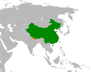
The bilateral relation between Nepal and China is defined by the Sino-Nepalese Treaty of Peace and Friendship signed on April 28, 1960, by the two countries. Though initially unenthusiastic, Nepal has been of late making efforts to increase trade and connectivity with China. Relations between Nepal and China got a boost when both countries solved all border disputes along the China–Nepal border by signing the Sino-Nepal boundary agreement on March 21, 1960, making Nepal the first neighboring country of China to agree to and ratify a border treaty with China. The government of both Nepal and China ratified the border agreement treaty on October 5, 1961. From 1975 onward, Nepal has maintained a policy of balancing the competing influence of China and Nepal's southern neighbor India, the only two neighbors of the Himalayan country after the accession of the Kingdom of Sikkim into India in 1975. In recent years, China has been making an effort to gain entry into SAARC, and, Nepal has continuously backed and supported the proposal to include China as a member in the regional grouping. Since 1975, Sino-Nepalese relations have been close and grown significantly, though India remains the largest source of total Foreign direct investment (FDI), and the third largest source of remittance to Nepal after Qatar and UAE. Based on the amount of remittance to Nepal sent by Nepalese migrants working in India, the government of Nepal estimate that there are around 1 million Nepalese migrant workers in India as of 2021, while the number of Nepalis in China is minuscule as of 2017.
The Bhutan–India border is the international border separating Bhutan and India. The border is 699 km long, and adjoins the Indian states of Assam, Arunachal Pradesh, West Bengal, and Sikkim.
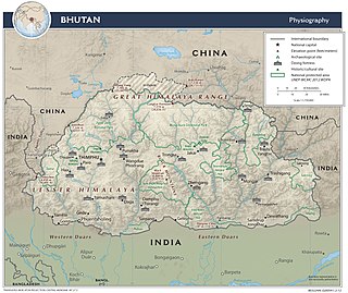
The Bhutan–China border is the international boundary between Bhutan and Tibet, China, running for 477 km (296 mi) through the Himalayas between the two tripoints with India.

The China–Nepal border is the international boundary between the Tibet Autonomous Region of China and Nepal. It is 1,389 kilometres (863 mi) in length and runs in a northwest–southeast direction along the Himalayan mountain range, including Mount Everest, the world's highest mountain. The boundaries of this particular border have changed dramatically over time, especially when considering relatively recent events such as the Annexation of Tibet in 1949. However, some of the most significant developments of modern times would be the signing of the "Agreement on Maintaining Friendly Relations between the People’s Republic of China and the Kingdom of Nepal" in 1956 and the "Sino-Nepalese Treaty of Peace and Friendship" in 1960, both of which formally recognised Tibet as a part of China and confirmed the limits of the countries of China and Nepal as they are known today.

Doklam, Zhoglam, or Donglang, is an area with a plateau and a valley, lying between China's Chumbi Valley to the north, Bhutan's Ha Valley to the east and India's Sikkim state's Nathang Valley to the west. It has been depicted as part of Bhutan in the Bhutanese maps since 1961, but it is also claimed by China. To date, the dispute has not been resolved despite several rounds of border negotiations between Bhutan and China. The area is of strategic importance to all three countries.
India shares borders with several sovereign countries; it shares land borders with China, Bhutan, Nepal, Pakistan, Bangladesh and Myanmar. Bangladesh and Pakistan share both land borders as well as maritime borders, while Sri Lanka shares only a maritime border. India's Andaman and Nicobar Islands share a maritime border with Thailand, Myanmar and Indonesia.
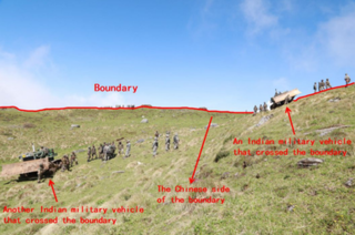
The 2017 China India border standoff or Doklam standoff refers to the military border standoff between the Indian Armed Forces and the People's Liberation Army of China over Chinese construction of a road in Doklam near a trijunction border area, known as Donglang, or Donglang Caochang, in Chinese. On 16 June 2017 Chinese troops with construction vehicles and road-building equipment began extending an existing road southward in Doklam, a territory which is claimed by both China as well as India's ally Bhutan. On 18 June 2017, as part of Operation Juniper, about 270 Indian troops armed with weapons and two bulldozers crossed the Sikkim border into Doklam to stop the Chinese troops from constructing the road. On 28 August, both India and China announced that they had withdrawn all their troops from the face-off site in Doklam.
The Five Fingers of Tibet is a Chinese foreign policy attributed to Mao Zedong that considers Tibet to be China's right hand palm, with five fingers on its periphery: Ladakh, Nepal, Sikkim, Bhutan, and Arunachal Pradesh, and that it is China's responsibility to "liberate" these regions. It was never discussed in official Chinese public statements, but external concerns have been raised over its possible continued existence or revival. An article in a provincial mouthpiece magazine of the Chinese Communist Party verified the existence of this policy in the aftermath of the 2017 China–India border standoff.

Chinese irredentism refers to irredentist claims to territories of the former Chinese Empire made by the Republic of China (ROC) and subsequently the People's Republic of China (PRC).

Barahoti, located in the Indian state of Uttarakhand, Chamoli district, is an 80 square kilometres (31 sq mi) sloping pasture. It is south of the Tunjun-la Pass, on the Ganges side of the Sutlej–Ganges water divide.

This article is about territorial disputes of the People's Republic of China (PRC). A territorial dispute is a disagreement over the possession or control of land between two or more political entities. Many of these territorial disputes are almost identical to the Republic of China (ROC) government based in Taipei, also known as Taiwan, has with other countries. Therefore, many of the subsequent resolved disputes made by the PRC after 1949 with other governments may not be recognised by the ROC.
