Related Research Articles
The geography of Argentina describes the geographic features of Argentina, a country located in Southern South America. Bordered by the Andes in the west and the South Atlantic Ocean to the east, neighbouring countries are Chile to the west, Bolivia and Paraguay to the north, and Brazil and Uruguay to the northeast.

Niger is a state in the Middle Belt region of Nigeria and the largest state in the country. The state's capital is at Minna. Other major cities are Bida, Kontagora and Suleja. It was formed in 1976 when the then North-Western State was bifurcated into Niger State and Sokoto State. It is home to Ibrahim Babangida and Abdulsalami Abubakar, two of Nigeria's former military rulers. The Nupe, Gbagyi, Kamuku, Kambari, Gungawa, Hun-Saare, Hausa and Koro form the majority of numerous indigenous tribes of Niger State.

Yankari National Park is a large wildlife park located in the south-central part of Bauchi State, in northeastern Nigeria. It covers an area of about 2,244 square kilometres (866 sq mi) and is home to several natural warm water springs, as well as a wide variety of flora and fauna. Its location in the heartland of the West African savanna makes it a unique way for tourists and holidaymakers to watch wildlife in its natural habitat. Yankari was created as a game reserve in 1956, but later designated Nigeria's biggest national park in 1991. It is the most popular destination for tourists in Nigeria and, as such, plays a crucial role in the development and promotion of tourism and ecotourism in Nigeria. It is also one of the most popular eco-destinations in West Africa.

Kainji Lake, in North Central Nigeria, is a reservoir on the Niger River, formed by the Kainji Dam. It was formed in 1968 and is a part of Niger State and Kebbi State. Kainji Lake National Park (KNLP), situated around the lake, is Nigeria's oldest National Park, established in 1976.

Kainji National Park is a national park in Niger State and Kwara State, Nigeria. Established in 1978, it covers an area of about 5,341 km2 (2,062 sq mi). The park includes three distinct sectors: a part of the Kainji Lake in which fishing is restricted, the Borgu Game Reserve to the west of the lake, and the Zugurma Game Reserve to the southeast.
New Bussa is a town in Niger State, Nigeria. It is the new site of Bussa after the Kainji Lake dam set the previous location underwater. As of 2007 New Bussa had an estimated population of 24,449. New Bussa is the headquarters of the Borgu Emirate and the Borgu Local Government Area.

Bussa, also known as Boussa in older texts, was the capital of northern Borgu, in northern Nigeria. It was the farthest navigable point on the Niger River, just above the rapids. The town site is now covered by Lake Kainji, which was created in 1968 with the construction of the Lake Kainji dam. The town was re-located to what is now called New Bussa.

Niassa Reserve is a nature reserve in Cabo Delgado Province and Niassa Province, Mozambique. Covering over 42,000 square kilometres, it is the largest protected area in the country. The reserve is part of the Trans-Frontier Conservation Area and links to the Tanzanian Lukwika-Lumesule Game Reserve. It will connect to the Lake Niassa Reserve when it is completed.
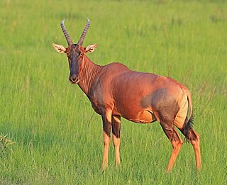
Damaliscus lunatus jimela is a subspecies of topi, and is usually just called a topi. It is a highly social and fast type of antelope found in the savannas, semi-deserts, and floodplains of sub-Saharan Africa.

Baruten is a Local Government Area in the North Central district of Kwara State, Nigeria, sharing a long border with the Republic of Benin. The local government begins in Ilesha Baruba and ends in Chikanda which is the border town. Its headquarters is in the town of Kosubosu.
Mariga is a Local Government Area in Niger State, Nigeria. Its headquarters are in the town of Bangi in the north of the area. Other towns in the LGA are Igwama and Inkwai. Various endangered Kamuku languages are spoken in Mariga LGA.
The Borgu Local Government Area is an administrative region in Niger State, Nigeria, one of 25 Local Government Areas (LGAs) in that state, with headquarters in the town of New Bussa. The postal code is 913. The Borgu LGA was formerly part of Kwara State, but on 27 August 1991 it was transferred to Niger State.
The Zugurma Game Reserve is a section of the Kainji National Park, in the Mariga Local Government Area of Niger State, Nigeria. It is bordered by the Kontagora River to the northwest and the Manyara River to the north, and covers an area of 138,500 hectares. It was amalgamated with the Borgu Game Reserve in 1975 to form the Kainji Lake National Park.

The Chad Basin National Park is a national park in northeastern Nigeria, in the Chad Basin, with a total area of about 2,258 km2. The park is fragmented, with three sectors. The Chingurmi-Duguma sector is in Borno State, in a Sudanian Savanna ecological zone. The Bade-Nguru Wetlands and Bulatura sectors are in Yobe State in the Sahel ecological zone.
The Kamuku National Park is a Nigerian national park in Kaduna State, Nigeria, with a total area of about 1,120 km2 (430 sq mi). The park has a typical Sudanian Savanna ecology.

Tanzania contains some 20 percent of the species of Africa’s large mammal population, found across its reserves, conservation areas, marine parks, and 17 national parks, spread over an area of more than 42,000 square kilometres (16,000 sq mi) and forming approximately 38 percent of the country's territory. Wildlife resources of Tanzania are described as "without parallel in Africa" and "the prime game viewing country". Serengeti National Park, the country's second largest national park area at 14,763 square kilometres (5,700 sq mi), is located in northern Tanzania and is famous for its extensive migratory herds of wildebeests and zebra while also having the reputation as one of the great natural wonders of the world. The Ngorongoro Conservation Area, established in 1959, is a UNESCO World Heritage Site and inhabited by the Maasai people. Its Ngorongoro Crater is the largest intact caldera in the world.

The wildlife of South Sudan refers to the natural flora and fauna of South Sudan. South Sudan includes the Sudd, one of the world's largest wetlands. According to the American biologist and conservationist, J. Michael Fay, South Sudan "could present the biggest migration of large mammals on earth", while Wildlife Conservation Society (WCS) reports southeast Sudan has a migration of 1.3 million antelopes. The region has a low density human population, with approximately 7 million people spread over approximately 619,745 km2 (239,285 sq mi).
Yumbarra Conservation Park, formerly the Yumbarra National Park, is a protected area in the Australian state of South Australia located about 55 kilometres north of the town centre of Ceduna.
Natural areas in Nigeria include:
References
- ↑ "Kainji Lake National Park". United Nations Environment Programme: World Conservation Monitoring Centre. Archived from the original on 2007-09-30. Retrieved 2010-10-21.
- ↑ Union internationale pour la conservation de la nature et de ses ressources. Antelope Specialist Group. Antelopes : global survey and regional action plans. IUCN. p. 84. ISBN 2-8317-0016-7.
Coordinates: 10°02′28″N4°03′36″E / 10.041°N 4.060°E
| | This Niger State, Nigeria location article is a stub. You can help Wikipedia by expanding it. |