
Assam is a state in northeastern India, south of the eastern Himalayas along the Brahmaputra and Barak River valleys. Assam covers an area of 78,438 km2 (30,285 sq mi). It is the second largest state in northeastern India by area and the largest in terms of population. The state is bordered by Bhutan and Arunachal Pradesh to the north; Nagaland and Manipur to the east; Meghalaya, Tripura, Mizoram and Bangladesh to the south; and West Bengal to the west via the Siliguri Corridor, a 22-kilometre-wide (14 mi) strip of land that connects the state to the rest of India. Assamese and Boro are the official languages of Assam. Meitei (Manipuri) is the official language of Hojai district and the entirety of the Barak Valley districts, while Bengali is an official language in the three districts of Barak Valley.

Dibrugarh district (Pron:ˌdɪbru:ˈgor:) is a district in the state of Assam in India. The district headquarters are located within the city of Dibrugarh.

Sonitpur district [Pron: ˌsə(ʊ)nɪtˈpʊə or ˌʃə(ʊ)nɪtˈpʊə] is an administrative district in the state of Assam in India. The district headquarters is located at Tezpur.

Dimapur is the largest city and municipality in the Indian state of Nagaland. As of 2011, the municipality had a population of 122,834. The city is the main gateway and commercial centre of Nagaland. Located near the border with Assam along the banks of the Dhansiri River. Its main railway station is the second busiest station in Northeast India.The District of Dimapur is bifurcated into two other District namely Chumoukedima and Niuland.

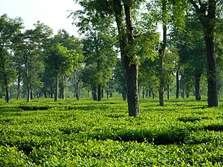
Namrup is a small town situated close to the foothills of the Patkai Hills in the extreme southeastern part of Assam, India. The river Dihing or Disang flows through it. Namrup is situated in amidst wet-paddy fields, indigenous Assamese villages, orchards, large tea-gardens and densely forested hills. Administratively Namrup is located within Dibrugarh district and is today an important industrial town of Assam. Namrup is approximately 75 km from Dibrugarh by road towards the south-east and approximately 50 km from Tinsukia towards the south. It is also a small railway station in Dibrugarh-Guwahati broad-gauge railway line. The nearest airport is Dibrugarh located at a distance of approximately 70 km. Other urban areas close to Namrup are Naharkatiya - 18 km, Duliajan - 35 km, Sonari - 20 km, Moran - 55 km, etc. by roadways. Namrup is located around 500 km east of Guwahati, the largest city in the North East Region.
Dibrugarh is an industrial city in Upper Assam with sprawling tea gardens. It is located 435 kms East from the state capital of Dispur. It serves as the headquarters of Dibrugarh district in the state of Assam in India. Dibrugarh serves as the headquarters of the Sonowal Kachari Autonomous Council, which is the governing council of the Sonowal Kachari tribe.

Golaghat one of the largest subdivisions of the Indian state of Assam, later elevated to the position of a full–fledged district headquarter on 5 October 1987, is a city and a municipality and the seat of administrative operations of Golaghat district, besides being a twin city to Jorhat which is about 55 km away. It is one of the oldest urban areas in Assam that recently featured on the Smart Cities nominations list, along with Guwahati and four other prominent urban areas of the state; although losing out to Guwahati at the final stage. The Dhansiri, one of the tributaries of the Brahmaputra, passes through Golaghat and is the primary water source for its citizens.

Tinsukia district is one of the 34 administrative districts in the state of Assam, India. The district headquarters is located at Tinsukia city. The district occupies an area of 3790 km2.

The Ahom kingdom was a late medieval kingdom in the Brahmaputra Valley that retained its independence for nearly 600 years despite encountering Mughal expansion in Northeast India. Established by Sukaphaa, a Tai prince from Mong Mao, it began as a mong in the upper reaches of the Brahmaputra based on wet rice agriculture. It expanded suddenly under Suhungmung in the 16th century and became multi-ethnic in character, casting a profound effect on the political and social life of the entire Brahmaputra valley. The kingdom became weaker with the rise of the Moamoria rebellion, and subsequently fell to repeated Burmese invasions of Assam. With the defeat of the Burmese after the First Anglo-Burmese War and the Treaty of Yandabo in 1826, control of the kingdom passed into East India Company hands.
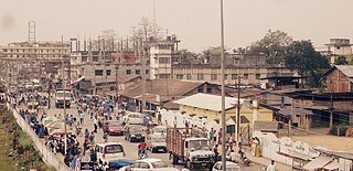
Naharkatia is a town and a Municipal board in Dibrugarh district in the Indian state of Assam. It is well known for petroleum and gas reserves. Earlier, Duliajan, the head office town of Oil India Limited was in its circle. However, the towns are close, within a 30-minute journey.
Nazira is a town and a municipal board in Sivasagar district in the Indian state of Assam.
Sonari is a district Headquarter, mid-size town and a municipal board in newly announced Charaideo district in the Indian state of Assam.
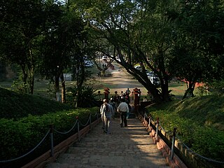
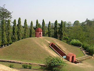
Charaideo or Che-Rai-Doi is a historic town situated in Charaideo district, Assam, India. Charaideo was established by the first Ahom king Chao Lung Siu-Ka-Pha in the year 1253 CE as the first capital of the Ahom kingdom. Even though the capital was shifted to different cities over the course of 600 years of Ahom rule, Charaideo remained the symbolic centre of Ahom power in Assam. It is now famous for its vast collection of maidams (tumuli) which are the burial mounds of the ruling Ahom kings and members of the Ahom royalty.

Sutanphaa also Siva Singha was the 31st king of Assam from the Ahom dynasty who reigned from He was the eldest son of King Rudra Singha. Siva Singha was with his dying father at Guwahati, who then proceeded to the capital Rangpur where he ascended to the throne. He is noted for his elaborate system of espionage. He had numerous temples erected and made large gifts of land to them. With his patronage, Hinduism became the pre-dominant religion of the Ahoms. The king was also a patron of music and literature and music and himself composed Sanskrit songs and learnt songs. His reign coincided with the arrival of the first Europeans traders into Assam.

Assam is the main and oldest state in the North-East Region of India and as the gateway to the rest of the Seven Sister States. The land of red river and blue hills, Assam comprises three main geographical areas: the Brahmaputra Valley which stretching along the length of the Brahmaputra river, the Barak Valley extending like a tail, and the intervening Karbi Plateau and North Cachar Hills. Assam shares its border with Meghalaya, Arunachal Pradesh, Nagaland, Manipur, Tripura, Mizoram and West Bengal; and there are National Highways leading to their capital cities. It also shares international borders with Bhutan and Bangladesh and is very close to Myanmar. In ancient times Assam was known as Pragjyotisha or Pragjyotishpura, and Kamarupa.

The Chutia Kingdom was a late medieval state that developed around Sadiya in present Assam and adjoining areas in Arunachal Pradesh. It extended over almost the entire region of present districts of Lakhimpur, Dhemaji, Tinsukia, and some parts of Dibrugarh in Assam, as well as the plains and foothills of Arunachal Pradesh. The kingdom fell around the year 1524 to the Ahom Kingdom after a series of conflicts and the capital area ruled by the Chutia rulers became the administrative domain of the office of Sadia Khowa Gohain of the Ahom kingdom.
Boiragimoth is a suburb of Dibrugarh city in Assam, consisting of several residential neighbourhoods and local markets. It is considered one of the most popular residential areas in the town, with shops, restaurants, schools, colleges, boarding houses, places of worship, sports facilities, and so on.
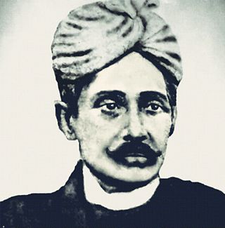
Maniram Dutta Baruah, popularly known as Maniram Dewan, was an Assamese nobleman in British India. He was one of the first people to establish tea gardens in Assam. While he was a loyal ally of the British East India Company in his early years, late he was hanged by the British for conspiring against them during the 1857 uprising. He was popular among the people of Upper Assam as "Kalita Raja".
Charaideo district is an administrative district in the state of Assam in India. It was formally declared a new district of the state on 15 August 2015 by then Chief Minister of Assam Tarun Gogoi. It has been carved out of Sivasagar district with Sonari as its administrative headquarter. It comes under Upper Assam division.
Arup Kumar Datta is an Indian writer and Journalist from Guwahati, Assam. He has written 18 books for adults and 17 adventure novels for young people. In 2014 he was awarded the Life Time Achievement Honour by Association of Writers and illustrators for Children, New Delhi, the Indian chapter of the International Board of Books for Young People. He has also won numerous awards including the Shankar's Award in 1979, conferred to mark The International Year of the Child. He has been awarded the civilian award Padma Shri by Government of India in 2018.

