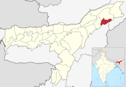
Charaideo district

Last updated
Charaideo district
Charaideo Maidam of Ahom Kings at Charaideo in Sivasagar, Assam 4.jpg
Maidam of Ahom Kings
Charaideo in Assam (India).svg
Location in Assam
Charaideo district
Charaideo district
CountryFlag of India.svg  India
State Assam
Division Upper Assam
Headquarters Sonari
Government
   Lok Sabha constituencies Jorhat
   Vidhan Sabha constituencies Mahmara, Sonari
Area
  Total1,069 km2 (413 sq mi)
Population
 (2011)
  Total471,418
  Density440/km2 (1,100/sq mi)
Languages
  Official Assamese
Time zone UTC+5:30 (IST)
Vehicle registration AS 33
Website charaideo.assam.gov.in

Charaideo district is an administrative district in the state of Assam in India. It was formally declared a new district of the state on 15 August 2015 by then Chief Minister of Assam Tarun Gogoi. [1] It has been carved out of Sivasagar district with Sonari as its administrative headquarter. It comes under Upper Assam division. [2] [3] [4]

Contents

Etymology

Charaideo was established by the first Ahom king Chaolung Sukaphaa. [5] The name Charaideo originated from Tai-Ahom word Che Rai Doi or Doi Che Rai which means the shining city on the hills. The Che-Rai-Doi Assamised into Charaideo or Charai-khorong. [6] [7]

History

Before the arrival of Sukaphaa the place was a place of worship for local tribes like Morans, Borahis and Sutiyas. [8]

The site of Charaideo was the capital of the Ahom kingdom established by the first Ahom king Chao Lung Siu-Ka-Pha in 1253. The Maidams (tumulus) of the Ahom kings and queens at Charaideo hillocks resemble the shape of small pyramids. The site has had some archaeological works but also has suffered from robbers. [9] There have been calls for the site to be UNESCO World Heritage listed. [10]

During the reign of Sudangphaa (1397–1407), the relatively small Ahom kingdom was attacked by Mong Kwang, a Shan state in what is today Upper Burma. A Mong Kwang army sent under General Ta-chin-Pao advanced upto Tipam but was subsequently defeated and pushed back as far as the Kham Jang territory. [11] The generals of the two armies conducted a peace treaty on the shore of the Nong Jake lake and in accordance with the Tai custom dipped their hands in the lake, fixing the boundary of the two kingdoms at Patkai hills. [11]

Demographics

Religions in Charaideo district (2011) [12]
ReligionPercent
Hinduism
88.00%
Christianity
5.24%
Islam
4.58%
Other (tribal religion)
1.25%
Buddhism
0.72%
Other or not stated
0.21%

The district has a population of 471,418, of which 29,723 (6.31%) live in urban areas. [13] Charaideo has a sex ratio of 955 females per 1000 males. Scheduled Castes and Scheduled Tribes make up 7,643 (1.62%) and 11,909 (2.53%) of the population respectively. [14]

Languages of Charaideo district (2011) [15]

   Assamese (75.64%)
   Sadri (7.64%)
   Bengali (4.22%)
   Odia (3.20%)
   Hindi (1.92%)
  'Other' Hindi (1.80%)
   Nepali (1.38%)
  Others (4.20%)

At the time of the 2011 census, 75.64% of the population spoke Assamese, 7.64% Sadri, 4.22% Bengali, 3.20% Odia, 1.92% Hindi, 1.38% Nepali. 1.80% of the population spoke 'Others' under Hindi. [15]

Notable people

See also

Notes

  1. Assam gets five more districts
  2. Charaideo commonly known as pyramids of Assam
  3. reparations afoot for inauguration of Charaideo district at Sonari
  4. Palasbari incensed over choice of district HQ
  5. Gogoi, Padmeswar (1968). The Tai and the Tai kingdoms: with a fuller treatment of the Tai-Ahom kingdom in the Brahmaputra Valley. Dept. of Publication, Gauhati University. pp. 264 & 265.
  6. Gohain, Birendra Kr (1999). Origin of the Tai and Chao Lung Hsukapha: A Historical Perspective. Omsons Publications. pp. 72 & 73.
  7. Bezbaruah, Ranju; Banerjee, Dipankar; Research, Indian Council of Historical (2008). North-East India: interpreting the sources of its history. Indian Council of Historical Research. p. 117. ISBN   9788173052958.
  8. ( Dutta 1985 :50)
  9. Dutta, Pullock; Das, Ripunjoy (2003-03-01). "Bounty hunters beat ASI to tombs". The Telegraph. Calcutta, India. Archived from the original on May 25, 2011. Retrieved 2007-12-06.
  10. Das, Ripunjoy (2006-01-19). "Saving Ahom kingdom - Local youths push for Unesco tag to protect Charaideo". The Telegraph. Calcutta, India. Archived from the original on May 25, 2011. Retrieved 2007-12-06.
  11. 1 2 Phukan 1991, p. 891.
  12. "Table C-01 Population By Religion: Assam". census.gov.in. Registrar General and Census Commissioner of India. 2011.
  13. "District Census Handbook: Sivasagar" (PDF). censusindia.gov.in. Registrar General and Census Commissioner of India. 2011.
  14. "Charaideo at a glance | Charaideo District | Government Of Assam, India". charaideo.gov.in. Archived from the original on 2021-01-17. Retrieved 2020-11-09.
  15. 1 2 "Table C-16 Population By Mother Tongue: Assam". censusindia.gov.in. Registrar General and Census Commissioner of India. 2011.

Related Research Articles

<span class="mw-page-title-main">Ahom people</span> Ethnic group from Assam

The Ahom or Tai-Ahom is an ethnic group from the Indian states of Assam and Arunachal Pradesh. The members of this group are admixed descendants of the Tai people who reached the Brahmaputra valley of Assam in 1228 and the local indigenous people who joined them over the course of history. Sukaphaa, the leader of the Tai group and his 9,000 followers established the Ahom kingdom, which controlled much of the Brahmaputra Valley in modern Assam until 1826.

<span class="mw-page-title-main">Ahom dynasty</span> Dynasty that ruled the Ahom kingdom in modern day Assam, India

The Ahom dynasty (1228–1826) ruled the Ahom Kingdom in present-day Assam, India for nearly 598 years. The dynasty was established by Sukaphaa, a Shan prince of Mong Mao who came to Assam after crossing the Patkai mountains. The rule of this dynasty ended with the Burmese invasion of Assam and the subsequent annexation by the British East India Company following the Treaty of Yandabo in 1826.

<span class="mw-page-title-main">Golaghat district</span> District of Assam in India

Golaghat district (Pron:ˌgəʊləˈgɑ:t) is an administrative district in the state of Assam in India. It attained district status in 1987. The district headquarters are located at Golaghat. The district occupies an area of3,502 km2 (1,352 sq mi) and lies 100 metres (330 ft) above sea level.

<span class="mw-page-title-main">Sivasagar</span> Municipality in Assam, India

Sivasagar is a town and headquarter of the Sivasagar district, Assam. Sivasagar is situated about 360 kilometers (224 mi) northeast of Guwahati. It is well known for its Ahom palaces and monuments. Sivasagar is an important centre for tea and oil industries today.

<span class="mw-page-title-main">Tinsukia</span> Town in Assam, India

Tinsukia is an industrial town. It is situated 480 kilometres (298 mi) north-east of Guwahati and 84 kilometres (52 mi) away from the border with Arunachal Pradesh.Tinsukia serves as the headquarters of the Moran Autonomous Council, which is the governing council of the Morans.

<span class="mw-page-title-main">Sivasagar district</span> District in Assam, India

Sivasagar district, formerly known as Sibsagar, is one of the 34 districts of Assam state in Northeast India. Sivasagar city is the administrative headquarters of this district. This historic place is also known for its rich biodiversity. The districts covers an area of 2668 square kilometers. The district comprises two sub-divisions – Sivasagar and Nazira. The district of Sivasagar lies between 26.45°N and 27.15°N latitudes and 94.25°E and 95.25°E longitudes. The district is bounded by the Brahmaputra River to the north, Nagaland to the south, the Charaideo district to the east and the Jhanji River to the west. The Sivasagar district has acquired its distinct identity due to the co-existence of different races, tribes, languages and cultures.

<span class="mw-page-title-main">Tinsukia district</span> District of Assam in India

Tinsukia district is one of the 34 administrative districts in the state of Assam, India. The district headquarters is located at Tinsukia city. The district occupies an area of 3790 km2.

<span class="mw-page-title-main">Sukaphaa</span> Ahom king

Sukaphaa, also Siu-Ka-Pha, the first Ahom king in medieval Assam, was the founder of the Ahom kingdom and the architect of Assam. A prince of the Su/Tsu (Tiger) clan of the Mao-Shan sub-tribe originally from present-day Mong Mao, Yunnan Province, China, the kingdom he established in 1228 existed for nearly six hundred years and in the process unified the various ethnic groups of the region that left a deep impact on the region. In reverence to his position in Assam's history the honorific Chaolung is generally associated with his name.

<span class="mw-page-title-main">Ahom kingdom</span> Kingdom in the Brahmaputra Valley in Assam, India

The Ahom kingdom was a late medieval kingdom in the Brahmaputra Valley that retained its independence for nearly 600 years despite encountering Mughal expansion in Northeast India. Established by Sukaphaa, a Tai prince from Mong Mao, it began as a mong in the upper reaches of the Brahmaputra based on wet rice agriculture. It expanded suddenly under Suhungmung in the 16th century and became multi-ethnic in character, casting a profound effect on the political and social life of the entire Brahmaputra valley. The kingdom became weaker with the rise of the Moamoria rebellion, and subsequently fell to repeated Burmese invasions of Assam. With the defeat of the Burmese after the First Anglo-Burmese War and the Treaty of Yandabo in 1826, control of the kingdom passed into East India Company hands.

Sonari is a district Headquarter, mid-size town and a municipal board in newly announced Charaideo district in the Indian state of Assam.

<span class="mw-page-title-main">Garhgaon</span> Historical place in Assam, India

Garhgaon is a historic town in Assam, India and served as the capital of the Ahom kingdom for many years. It was built by the Ahom king Suklenmung in 1540. Suklenmung who intervened against a Toungoo dynasty attack on MongKwang in Kachin State of Myanmar was married to the princess Nang Sao Seng, the daughter of Chao Siu-Kwei of MongKwang. It is said that the Ahom capital Garhgoan was built at the suggestion of this Mong Kwang queen Nang Sao Seng. In 1575, the king of Mongkwang, Chao Ka Pha II took shelter in Ahom territory after his state was devastated by the Burmese. It lies 13 km east of present-day Sivasagar town, headquarters of the Sivasagar district. The palace structures were made of stone and wood. In 1747 Pramatta Singha, son of Rudra Singha, constructed a brick wall of about 5 km in length surrounding the Garhgaon palace and the masonry gate leading to it.

<span class="mw-page-title-main">Charaideo</span> Human settlement in India

Charaideo or Che-Rai-Doi is a historic town situated in Charaideo district, Assam, India. Charaideo was established by the first Ahom king Chao Lung Siu-Ka-Pha in the year 1253 CE as the first capital of the Ahom kingdom. Even though the capital was shifted to different cities over the course of 600 years of Ahom rule, Charaideo remained the symbolic centre of Ahom power in Assam. It is now famous for its vast collection of maidams (tumuli) which are the burial mounds of the ruling Ahom kings and members of the Ahom royalty.

<span class="mw-page-title-main">Maidam</span> Tumuli of the Ahom Kingdom

A maidam is a tumulus of the royalty and aristocracy of the medieval Ahom Kingdom (1228–1826) in Assam. The royal maidams are found exclusively at Charaideo; whereas other maidams are found scattered in the region between Jorhat and Dibrugarh towns. Structurally, a maidam consists of vaults with one or more chambers. The vaults have a domical superstructure that is covered by a hemispherical earthen mound that rises high above the ground with an open pavilion at the peak called chow chali. An octagonal dwarf wall encloses the entire maidam.

<span class="mw-page-title-main">Upper Assam division</span> Division in Assam, India

Upper Assam is an administrative division of the state of Assam comprising the undivided Lakhimpur and Sivasagar districts, of the upper reaches of the Brahmaputra valley. The other divisions are: Lower Assam, North Assam and Hills and Barak Valley. The division is under the jurisdiction of a Commissioner, stationed at Jorhat.

<span class="mw-page-title-main">Talatal Ghar</span> Building in Assam, India

The Talatal Ghar ) is an 18th-century palace and military base located in Rangpur, 4 kilometres (2.5 mi) from present-day Sivasagar, Assam, India. It is the largest of the monument built during the Ahom era. King Rudra Singha was responsible for the construction of Kareng Ghar, but the present structure was built by king Rajeswar Singha (Surempha). It was initially built as an army base. It had 2 tunnels and 3 underground floors. Currently this structure is in dilapidated condition, the present ruins betray the grandeur that the palace was once endowed with.

All Tai Ahom Students Union (ATASU) or Chom Hom Lik Hen Tai Ahom Tang Mung in Ahom language is a students' union in Assam, India.

Assam – 16th largest, 15th most populous and 26th most literate state of the 28 states of the democratic Republic of India. Assam is at 14th position in life expectancy and 8th in female-to-male sex ratio. Assam is the 21st most media exposed states in India. The Economy of Assam is largely agriculture based with 69% of the population engaged in it. Growth rate of Assam's income has not kept pace with that of India's during the Post-British Era; differences increased rapidly since the 1970s. While the Indian economy grew at 6 percent per annum over the period of 1981 to 2000, the same of Assam's grew only by 3.3 percent.

<span class="mw-page-title-main">Ahom religion</span> Ethnic religion of the Ahom people

The Ahom religion is the ethnic religion of the Ahom people. The Ahom people came into Assam in 1228, led by a Tai prince Sukaphaa, and admixed with the local people. The people who came into Assam included two clans of priests, joined later by a third, who brought with them their own religion, rituals, practices and scriptures. The religion is based on ritual-oriented ancestor worship that required animal sacrifice (Ban-Phi), though there was at least one Buddhism influenced ritual in which sacrifice was forbidden (Phuralung). Ancestor worship and the animistic concept of khwan are two elements it shares with other Tai folk religions. There is no idolatry except for the titular god of the Ahom king and though there is a concept of heaven or a heavenly kingdom, there is no concept of hell. It was the state religion of the Ahom kingdom in the initial period.

<span class="mw-page-title-main">Ahomisation</span> Assimilation process in the former Ahom kingdom of Assam

Ahomisation was an assimilation process in the former Ahom kingdom of Assam by which the people from different ethnic groups in the region became a part of what is now considered as the Ahom population.

<span class="mw-page-title-main">Moran people</span> Ethnic group found in the northeast Indian states of Assam and Arunachal Pradesh

The Moran are an ethnic group found in the northeast Indian states of Assam and Arunachal Pradesh. They are of Tibeto-Burman origin and belong to the Kachari family. They speak Assamese language, though they used to speak Moran language which was alive until the early 20th century and was closely related to the Dimasa language. They once shared the same allied customs with other Kachari groups, but after their conversion to Vaishnavism, the customs began to diminish, but still, those customs can be seen intermixed with Vaishnavism.

References

26°55′59″N94°44′53″E / 26.933°N 94.7481°E / 26.933; 94.7481