
The Ahom or Tai-Ahom is an ethnic group from the Indian states of Assam and Arunachal Pradesh. The members of this group are admixed descendants of the Tai people who reached the Brahmaputra valley of Assam in 1228 and the local indigenous people who joined them over the course of history. Sukaphaa, the leader of the Tai group and his 9,000 followers established the Ahom kingdom, which controlled much of the Brahmaputra Valley in modern Assam until 1826.

The Ahom dynasty (1228–1826) ruled the Ahom Kingdom in present-day Assam, India for nearly 598 years. The dynasty was established by Sukaphaa, a Shan prince of Mong Mao who came to Assam after crossing the Patkai mountains. The rule of this dynasty ended with the Burmese invasion of Assam and the subsequent annexation by the British East India Company following the Treaty of Yandabo in 1826.

The Battle of Saraighat was a naval battle fought in 1671 between the Mughal Empire, and the Ahom Kingdom on the Brahmaputra river at Saraighat, now in Guwahati, Assam, India. This was the decisive battle that ended the years long Mughal siege of Guwahati, with the Ahoms pushing away the Mughals west beyond the Manas river.
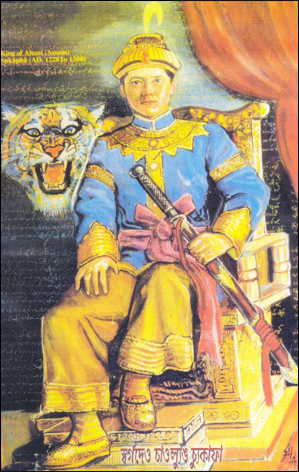
Sukaphaa, also Siu-Ka-Pha, the first Ahom king in medieval Assam, was the founder of the Ahom kingdom and the architect of Assam. A prince of the Su/Tsu (Tiger) clan of the Mao-Shan sub-tribe originally from present-day Mong Mao, Yunnan Province, China, the kingdom he established in 1228 existed for nearly six hundred years and in the process unified the various ethnic groups of the region that left a deep impact on the region. In reverence to his position in Assam's history the honorific Chaolung is generally associated with his name.
The Ahom kingdom, or the Kingdom of Assam was a late medieval kingdom in the Brahmaputra Valley that retained its independence for nearly 600 years despite encountering Mughal expansion in Northeast India. Established by Sukaphaa, a Tai prince from Mong Mao, it began as a mong in the upper reaches of the Brahmaputra based on wet rice agriculture. It expanded suddenly under Suhungmung in the 16th century and became multi-ethnic in character, casting a profound effect on the political and social life of the entire Brahmaputra valley. The kingdom became weaker with the rise of the Moamoria rebellion, and subsequently fell to repeated Burmese invasions of Assam. With the defeat of the Burmese after the First Anglo-Burmese War and the Treaty of Yandabo in 1826, control of the kingdom passed into East India Company hands.

Choapha Supatpha also Swargadeo Gadadhar Singha, was the twenty-ninth king of Ahom kingdom, who reigned from 1681 to 1696. He established the rule of Tungkhungia royal house of Ahom kings, whose descendants continued to rule till the climactic end of the Ahom kingdom in 1826. He was a son of Gobar raja, a descendant of Suhungmung, and who had become king for twenty days. Gadadhar Singha stabilized the Ahom kingdom, which was going through a long decade of political turmoil and instability. This period saw the ruthless power grab of Debera Borbarua and Laluksola Borphukan's abandonment of Guwahati to the hands of Mughals and oppression via Sulikphaa alias Lora Roja.
Buragohain was the one of the two original counsellors in the Ahom kingdom. He was selected by the Ahom king from members of the Ahom nobility ,who vowed not to fight for the position of Ahom kingship, rather act as a guide to the Ahom king in matters of administering his province in an efficient manner. The other original counsellor is Chao Thao Lung or Borgohain. Both the positions existed from the time of the first Ahom king, Sukaphaa.
Suremphaa, or Rajeswar Singha, the fourth son of Rudra Singha, became the king of the Ahom kingdom after the death of his brother King Pramatta Singha. Rudra Singha's third son, Mohanmala Gohain, was considered ineligible for kingship as his face was pitted with smallpox marks. According to the norm established after Sulikphaa Lora Roja, an Ahom prince had to be free from any physical disability, defects or deformities to become a king.

Habung is a historical region in present-day Lakhimpur district of Assam, India, although Tai-ahom claim it to be a part of present-day Dhemaji district. As per epigrahic records, Habung (Ha-vrnga-Vishaya) was a vishaya or province where Brahmins were settled by Ratna Pala of the Pala dynasty of Kamarupa in the 10th century.

Assam is the main and oldest state in the North-East Region of India and as the gateway to the rest of the Seven Sister States. The land of red river and blue hills, Assam comprises three main geographical areas: the Brahmaputra Valley which stretching along the length of the Brahmaputra river, the Barak Valley extending like a tail, and the intervening Karbi Plateau and North Cachar Hills. Assam shares its border with Meghalaya, Arunachal Pradesh, Nagaland, Manipur, Tripura, Mizoram and West Bengal; and there are National Highways leading to their capital cities. It also shares international borders with Bhutan and Bangladesh and is very close to Myanmar. In ancient times Assam was known as Pragjyotisha or Pragjyotishpura, and Kamarupa.
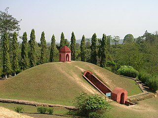
Frang-Mai-Dam or Moidam for short is a traditional tumulus of the Ahom religion. The royal maidams of Charaideo are listed as UNESCO world heritage site. Today, the people of the four clans namely Mo-Hung, Mo-Cham, Chaodang and Mo-Plong follow the tomb tradition of Ahom religion.

Upper Assam is an administrative division of the state of Assam comprising the undivided Lakhimpur and Sivasagar districts, of the upper reaches of the Brahmaputra valley. The other divisions are: Lower Assam, North Assam and Hills and Barak Valley. The division is under the jurisdiction of a Commissioner, stationed at Jorhat.

The Chutia kingdom was a late medieval state that developed around Sadiya in present Assam and adjoining areas in Arunachal Pradesh. It extended over almost the entire region of present districts of Lakhimpur, Dhemaji, Tinsukia, and some parts of Dibrugarh in Assam, as well as the plains and foothills of Arunachal Pradesh. The kingdom fell around the year 1524 to the Ahom Kingdom after a series of conflicts and the capital area ruled by the Chutia rulers became the administrative domain of the office of Sadia Khowa Gohain of the Ahom kingdom.
Sudangphaa (1397–1407) was a Chaopha of the Ahom kingdom. He was popularly known as Bamuni Konwar because of his upbringing in a Brahman's house. His reign marks the first stage in the growth of Hinduism in the Ahom dynasty. He initiated the Singarigharutha ceremony of the Ahom kings, a tradition which was followed by his successors.
Charaideo district is an administrative district in the state of Assam in India. It was formally declared a new district of the state on 15 August 2015 by then Chief Minister of Assam Tarun Gogoi. It has been carved out of Sivasagar district with Sonari as its administrative headquarter. It comes under Upper Assam division.

The Ahom Religion is the ethnic religion of the Ahom people. The Ahom people came into Assam in 1228, led by a Tai prince Sukaphaa, and admixed with the local people. The people who came into Assam included two clans of priests, joined later by a third, who brought with them their own religion, rituals, practices and scriptures. The religion is based on ritual-oriented ancestor worship that required animal sacrifice (Ban-Phi), though there was at least one Buddhism influenced ritual in which sacrifice was forbidden (Phuralung). Ancestor worship and the animistic concept of khwan are two elements it shares with other Tai folk religions. There is no idolatry except for the titular god of the Ahom king and though there is a concept of heaven or a heavenly kingdom, there is no concept of hell. It was the state religion of the Ahom kingdom in the initial period.

Ahomisation was an assimilation process in the former Ahom kingdom of Assam by which the people from different ethnic groups in the region became a part of what is now considered as the Ahom population.
Sariahtali is a village in Nalbari district, Assam, India. As per 2011 Census of India, Sariahtali has a population of 3,830 people with a literacy rate of 67.23%. The Government Industrial Training Institute (ITI), Nalbari is located in Sariahtali.
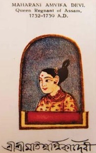
Ambika, Bar Raja was the Chief Consort of Ahom King, Sutanphaa. She became Bar Raja, shortly after the death of her older sister, Phuleshwari. She is known for constructing the Sivasagar Sivadol and the Sivasagar Tank. She was a great patron of learning and education.
Baduli Borphukan, also known as Baduli Roja Sahur was a loyal administrative officer in the Ahom Kingdom, serving during the reign of Ahom king Jayadhwaj Singha. He was also the brother of Momai Tamuli Borbarua, a prominent minister in the Ahom kingdom. As a Borphukan, Baduli Roja Sahur played a crucial role in the Ahom Kingdom's defense against the Mughal Empire. He fought valiantly against the Mughal Subahdar (governor) Mir Jumla II, who led a campaign against the Ahom Kingdom in the 17th century. Additionally, he played a key role in developing the kingdom's infrastructure, constructing the Seuni Ali road from Jorhat to the capital city Garhgaon. This road facilitated communication, and military movements, showcasing his vision and leadership. Baduli Borphukan's legacy continued through his son, Baduli Dekaphukan and grandson Maupia Phukan.


