
Longdendale is a valley in the Peak District of England, north of Glossop and southwest of Holmfirth. The name means "long wooded valley" and the valley is mostly in the counties of Derbyshire and Greater Manchester.

The River Etherow is a river in northern England, and a tributary of the River Goyt. Although now passing through South Yorkshire, Derbyshire and Greater Manchester, it historically formed the ancient county boundary between Cheshire and Derbyshire. The upper valley is known as Longdendale. The river has a watershed of approximately 30 square miles (78 km2), and the area an annual rainfall of 52.5 inches (1,330 mm).

Thirlmere is a reservoir in the Borough of Allerdale in Cumbria and the English Lake District. The Helvellyn ridge lies to the east of Thirlmere. To the west of Thirlmere are a number of fells; for instance, Armboth Fell and Raven Crag both of which give views of the lake and of Helvellyn beyond. It runs roughly south to north and is bordered on the eastern side for much of its length by the A591 road and on the western side by a minor road. It occupies the site of a former natural lake: this had a fordable waist so narrow that it was sometimes regarded as two lakes. In the 19th century Manchester Corporation constructed a dam at the northern end, raising the water level, flooding the valley bottom, and creating a reservoir to provide the growing industrial city of Manchester with water supplies via the 96 mile-long Thirlmere Aqueduct. The reservoir and the aqueduct still provide water to the Manchester area, but under the Water Act 1973 ownership passed to the North West Water Authority; as a result of subsequent privatisation and amalgamation they are now owned and managed by United Utilities, a private water and waste water company.

Hadfield is a town in the High Peak of Derbyshire, England, with a population at the 2021 Census of 6,763. It lies on the south side of the River Etherow, near to the border with Greater Manchester, at the western edge of the Peak District close to Glossop.
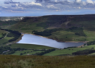
Dovestone Reservoir lies at the convergence of the valleys of the Greenfield and Chew Brooks above the village of Greenfield, on Saddleworth Moor in Greater Manchester, England. The reservoir is on the western edge of the Peak District National Park. It supplies drinking water to the surrounding area and is a tourist attraction, providing several walks amongst picturesque landscapes.

Woodhead is a small and scattered settlement at the head of the Longdendale valley in Derbyshire, England. It lies on the trans-Pennine A628 road connecting Greater Manchester and South Yorkshire, 6 miles (10 km) north of Glossop, 19 miles (31 km) east of Manchester and 18 miles (29 km) west of Barnsley. It is close to the River Etherow and the Trans Pennine Trail. Although part of Derbyshire since 1974, like nearby Tintwistle and Crowden, the hamlet was in the historic county of Cheshire.

Damflask Reservoir is situated at grid reference SK277907 five miles west of the centre of Sheffield in the Loxley valley close to the village of Low Bradfield and within the city's boundaries. The hamlet of Stacey Bank is located to the east. The reservoir has a capacity of 4,250.9 million litres and has a surface area of 47 hectares with a maximum depth of 27 metres. The dam wall is approximately 400 metres wide with a height of 28 metres.

Langsett Reservoir is in Yorkshire, England, near the villages of Langsett and Upper Midhope, on the edge of the Peak District National Park. The reservoir was constructed between 1898 and 1904, and is now managed by Yorkshire Water. Fed by the Little Don or Porter River, it is around a mile long, and supplies water for Sheffield and Barnsley via the Langsett Treatment Works.
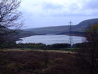
Woodhead reservoir is a man-made lake near the hamlet of Woodhead in Longdendale in north Derbyshire, England. It was constructed by John Frederick Bateman between 1847 and June 1877 as part of the Longdendale Chain of reservoirs to supply water from the River Etherow to the urban areas of Greater Manchester. It is at the top of the chain of reservoirs and was the first to be started, though, due to construction problems, it was the last to be completed.
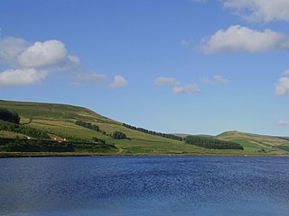
Torside Reservoir is the largest man-made lake in Longdendale in north Derbyshire, England. It was constructed by John Frederick Bateman between April 1849 and July 1864 as part of the Longdendale Chain of reservoirs to supply water from the River Etherow to the urban areas of Greater Manchester.

Rhodeswood Reservoir is a man-made lake in Longdendale in north Derbyshire, England. It was constructed by John Frederick Bateman between 1849 and June 1855 as part of the Longdendale Chain of reservoirs to supply water from the River Etherow to the urban areas of Greater Manchester. It is third in the chain, and it is from here that the water is extracted to pass through the Mottram Tunnel to Godley for Manchester.

ValehouseReservoir is a man-made lake in Longdendale in north Derbyshire, England. It was built between 1865 and 1869 as part of the Longdendale Chain of reservoirs, which was built to supply water from the River Etherow to the urban areas of Greater Manchester, while maintaining a constant flow into the river. The upper reservoirs supply the drinking water, while Vale House and Bottoms are compensation reservoirs which guarantee the flow of water to water-powered mills downstream. Valehouse, with a crest elevation of 503 metres (1,650 ft), is too low to supply water under gravity to the Mottram Tunnel, so could not be used as an impounding reservoir. Today 45 megalitres of compensation water are released each day into the River Etherow.

Arnfield Reservoir is a man-made lake in Longdendale in north Derbyshire, England. It was constructed in 1854 as part of the Longdendale chain to supply water from the River Etherow to the urban areas of Greater Manchester. Unlike the other reservoirs in the chain, Arnfield and Hollingworth Reservoir are not in the Etherow valley but lie in the valley of tributary brooks to the north and above. From Arnfield the water is extracted to pass through the Mottram Tunnel to Godley.

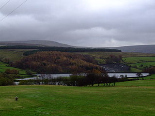
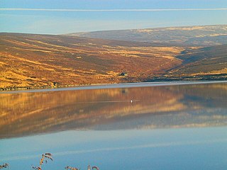
The Longdendale Chain is a sequence of six reservoirs on the River Etherow in the Longdendale Valley, in northern Derbyshire. They were constructed between 1848 and 1884 to a design by John Frederick Bateman to supply the growing population of Manchester and Salford with fresh water.
Hollingworth Reservoir is a former reservoir near Hollingworth, Tameside, Greater Manchester. The reservoir straddles the Greater Manchester–Derbyshire border. It was constructed in 1854 as part of the Longdendale Chain, but was abandoned in 1987 and now forms part of the Swallows Wood nature reserve.
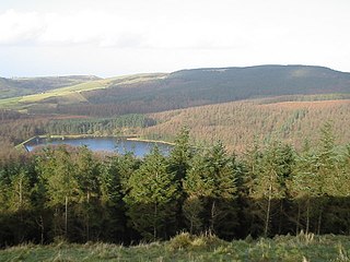
Trentabank Reservoir is within Macclesfield Forest, partly in the Peak District National Park, in England, and is home to rich unimproved uplands and grasslands. The reservoir is surrounded mainly by coniferous plantations and is also home to about 22 pairs of herons. The Peak District Boundary Walk runs past the reservoir.

Padfield is a small village near Hadfield in High Peak, Derbyshire, England. The village is on the west side of the Peak District National Park, and the nearest town is Glossop, where many local amenities and services are based. It is in a conservation area. The population as of the 2011 census was 2,796.
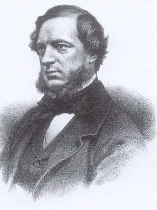
John Frederick La Trobe Bateman was an English civil engineer whose work formed the basis of the modern United Kingdom water supply industry. For more than 50 years from 1835 he designed and constructed reservoirs and waterworks. His largest project was the Longdendale Chain system that has supplied Manchester with much of its water since the 19th century. The construction of what was in its day the largest chain of reservoirs in the world began in 1848 and was completed in 1877. Bateman became "the greatest dam-builder of his generation".
For the reservoirs near Stalybridge, in Tameside, Greater Manchester, see Higher Swineshaw Reservoir and Lower Swineshaw Reservoir
For the reservoirs near Glossop, in Derbyshire, see Upper Swineshaw Reservoir and Swineshaw Reservoir (Derbyshire)


