There is a Roman fortlet at Highstones on the south-facing slope overlooking Torside Reservoir. It is an oval-shaped area, with an obvious ditch, and about 82 yards (75m) across. A footpath runs immediately to the north of it, and to the west is Highstones Farm. A Roman road may have run along the valley connecting it with Melandra Castle, in Glossop.[2]
Feudal estates
The lordship of Longdendale was an ancient feudal estate encompassing the medieval manors of Godley, Hattersley, Hollingworth, Matley, Mottram, Newton, Staley, Tintwistle and Werneth. The lordship was created by the Earl of Chester in the late twelfth century; William de Neville was the first lord of Longdendale, as appointed by the Earl of Chester.[3]Buckton Castle, near Carrbrook, was probably built by William de Neville in the late twelfth century[4] and was also probably the centre of lordship of Longdendale, as it is the only castle within the lordship.[5] One of the privileges of the lordship was to carry out trial by combat. The lordship of Longdendale was passed from de Neville to his son in law, Thomas de Burgh, upon his death in 1211.
The lordship reverted to the control of the crown in 1357 and remained under crown control until 1374. The lordship was given to Matilda Lovell and the Lovells controlled Longdendale until 1465, when control again reverted to the crown. The lordship was granted to Sir William Stanley in 1489; however, the lordship once again reverted to the crown when Stanley was executed in 1495 as a supporter of Perkin Warbeck. In 1554, the lordship was granted to Richard Wilbraham.[6] Tollemache family inherited lordship of Longdendale from the Wilbrahams in the 1690s.[7] It was part of the Hundred of Macclesfield. An estate survey, or 'Extent' of the lordship for 1360, was published by the Record Society of Lancashire and Cheshire in July 2005.
Salt trade
Lady Shaw Bridge
A packhorse route called a saltway was maintained from the Middle Ages onwards for the purpose of allowing the export of salt from the Cheshire wiches of Nantwich, Northwich and Middlewich across the Pennines. The passing trade brought prosperity to settlements along the route. The importance of the salt trade along such saltways is shown by surviving placenames; for example Salter's Brook (SK137999) is where the saltway forked, with one route leading to Wakefield and another to Barnsley.
The stone Lady Shaw Bridge is extant at this point, as do the ruins of an old inn. The bridge is just wide enough for a packhorse, though it is suspected that the bridge may have originally been wider and was deliberately narrowed when the Saltersbrook turnpike was built, to prevent vehicles bypassing the toll barrier.[citation needed]
Turnpike road
The turnpike road from Manchester to Saltersbrook connected to further turnpikes for Yorkshire destinations and was built in the mid-18th century, based on the older saltway route.
The reservoirs
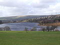
The view eastward up Longdendale from Padfield, in Derbyshire
The Longdendale catchment exceeds 30 square miles (78km2) and has an annual rainfall of 1,330 millimetres (52.5in). The civil engineer John Frederick Bateman recognised the potential and conceived a plan to deliver this water to Manchester and Salford, while still maintaining the flow in the River Etherow that was needed to power the mills of Tintwistle and Glossop. The six reservoirs have a capacity of 20,000,000m3 (4,500,000,000impgal).[8] A tunnel was built at a depth of 200 feet (60m) to carry the water from Longdendale into the valley of the River Tame. The Manchester Corporation Waterworks Act 1847 (10 & 11 Vict. c. cciii) (9 July 1847) was passed to allow the land to be acquired and construction to commence.[9]
The first railway line between Manchester and Sheffield was constructed between 1839 and 1845, on the south side of the reservoir chain, by 1,500 navvies of whom many died and most suffered illness. The three mile-long double Woodhead Tunnel was, for a time, the longest tunnel in the country. It was replaced by a single, larger tunnel in 1954. The first tunnel was subsequently used by Central Electricity Generating Board to reroute the main high-voltage link up the valley and through the National Park underground.
In 1970, passenger services between Hadfield and Penistone ceased. Whilst the Beeching Report recommended the closure of the Hope Valley Line and retention of the Woodhead Line, the government implemented the opposite.[10] This was followed by the goods service in 1981, due to the falloff in trans-Pennine coal traffic.[11] The track was lifted in 1986. There have been plans to reopen the railway at various times since it was closed, but none have gained planning approval.
Recreation
Cycling and walking
Walking and riding on the Longdendale Trail, March 2008
Holme Moss and the Woodhead Pass were on the route of the 2014 Tour de France, during the second stage between York and Sheffield.[13]
The Pennine Way crosses Longdendale, descending from Bleaklow to the south and ascending Black Hill to the north. The youth hostel at Crowden is a traditional stop after the first day's walk from Edale. The circular walk known as 'The Longdendale Edges' takes in the high ground (at about the 1,000–1,500-foot (300–460m) level) on both sides of the valley. It is about 17 miles (27km) long and is 'not recommended in doubtful weather'. The detailed route, clockwise from Crowden Youth Hostel, is given in Peak District Walking Guide No.2, published by the Peak Park Planning Board.
Sailing
Torside Reservoir is home to Glossop Sailing Club.[14]
The Woodhead Pass is a major freight route and is often congested, which has created traffic problems at its western end. The Mottram to Tintwistle by-pass is intended to relieve the congestion;[15] work began to build the by-pass in 2024 and it is scheduled to be completed by 2028.[16]
The valley gave its name to the Longdendale Urban District, which covered the western part of the valley around Mottram and Hollingworth. That district was created in 1936, as one of the districts of Cheshire, and was abolished in 1974 when its area became part of the metropolitan borough of Tameside, in Greater Manchester.[17][18]
The valley and the surrounding area has a reputation for strange phenomena, including unexplained lights[19][20] and allegedly supernatural apparitions and has become a centre of attention for UFO and ghost hunters.[21] However, it has been suggested that the lights may be earth lights produced by pressure on the underlying rocks.[19]
↑Nevell, Mike (1998). Lands and Lordships in Tameside. Tameside Metropolitan Borough Council with the University of Manchester Archaeological Unit. pp.60–61, 63. ISBN1-871324-18-1.
↑Nevell, Mike; Walker, John (1999). Tameside in Transition. Tameside Metropolitan Borough with University of Manchester Archaeological Unit. p.95. ISBN1-871324-24-6.
↑Nevell, Mike (1991). Tameside 1066–1700. Tameside Metropolitan Borough with the University of Manchester Archaeological Unit. pp.11–13, 15, 39–40. ISBN1-871324-02-5.
↑Nevell, Mike (1993). Tameside 1700–1930. Tameside Metropolitan Borough with the University of Manchester Archaeological Unit. pp.17, 93. ISBN1-871324-08-4.
This page is based on this Wikipedia article Text is available under the CC BY-SA 4.0 license; additional terms may apply. Images, videos and audio are available under their respective licenses.