Bamba is a small town and rural commune in the Bourem Cercle of the Gao Region of Mali. The town is located on the left (north) bank of the Niger River, 190 km east of Timbuktu and 230 km northwest of the town of Gao. In the 2009 census the commune had a population of 28,524.

Ménaka Cercle is an administrative subdivision of Ménaka Region, Mali. Its administrative center is the town of Ménaka. Ménaka Cercle's population as of 2009 was 56,104 people. Ménaka is located in the middle of the Sahara Desert, along Wadi Ezgeuret and an ancient dry river valley of the Iullemmeden Basin. Its highest point, Mount Abourak, is located around 150 km to the north of the town of Ménaka. Most of the small population are nomadic Tuareg tribal populations; minorities include the Wodaabe Fula and sedentary Songhai people. The area is a traditional center of the Kel Dinnik Tuareg confederation, along with the town of Andéramboukane near the Nigerien border.
Diré Cercle is an administrative subdivision of the Tombouctou Region of Mali. The administrative center (chef-lieu) is the town of Diré.

Timbuktu Cercle is an administrative subdivision of the Tombouctou Region of Mali. It is the largest cercle by area in the whole of Mali. The capital lies at the city of Timbuktu. The cercle is divided into Rural and Urban Communes, and below this, quarters/villages. In the 2009 census the cercle had a population of 124,546.

Ansongo Cercle is an administrative subdivision of the Gao Region of Mali. The administrative center (chef-lieu) is the town of Ansongo. The Niger River passes through the cercle and plays an important role in transportation and the economy in the region.
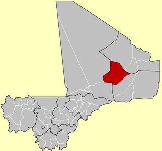
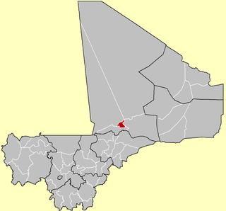
Bourem Cercle is an administrative subdivision of the Gao Region of north-eastern Mali. The administrative center (chef-lieu) is the town of Bourem.

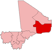
Gao Cercle is an administrative subdivision of the Gao Region of north-eastern Mali. The administrative center (chef-lieu) is the town of Gao.
Anefif or Anéfis is a Saharan village and commune in the Cercle of Kidal in the Kidal Region of north-eastern Mali.
Bara is a rural commune and village in the Cercle of Ansongo in the Gao Region of south-eastern Mali.
Tarkint is a village and commune in the Cercle of Bourem in the Gao Region of north-eastern Mali. The village is 70 km (43 mi) northeast of Bourem and 123 km (76 mi) from Gao. Tarkint extends for 23,000 km2 and includes part of the Tilemsi Valley. In the 2009 census Tarkint had a population of 19,082.
Taboye is a rural commune and village in the Cercle of Bourem in the Gao Region of south-eastern Mali. The commune is crossed by the River Niger and includes the villages of Bia, Dagha, Ha, Moudakane, Ouani, Tondibi and Taboye. In the 2009 census the commune had a population of 20,503.
Inékar is a village and cercle of Ménaka Region in southeastern Mali. It has an area of approximately 27,000 square kilometers and in 2009 had a population of 8,714. It was previously a commune in Ménaka Cercle but was promoted to the status of a cercle when Ménaka Region was implemented in 2016.
Tidermène is a village and cercle in Ménaka Region of southeastern Mali. In the 2009 census it had a population of 5,816. Its area is approximately 29,000 square kilometers. It was previously a commune in Ménaka Cercle but was promoted to the status of a cercle when Ménaka Region was created in 2016. From 2001 to 2016 the commune of Alata was separated from Tidermène. On 12 April 2023, the town was seized by the Islamic State in the Sahel.
Bourra is a commune in the Cercle of Ansongo in the Gao Region of south-eastern Mali. The commune extends along the left (east) bank of the River Niger. It covers an area of approximately 2,323 square kilometers and includes 14 villages. In the 2009 census the commune had a population of 19,163. The main village (chef-lieu) is Tassiga.
Gabero is a rural commune in the Cercle of Gao in the Gao Region of south-eastern Mali. The commune covers an area of approximately 2,007 square kilometers and includes 15 villages. In the 2009 census the commune had a population of 25,688. The Niger River crosses the commune from north to south. The administrative center (chef-lieu) is Haoussa Foulane that lies on the left (east) bank of the Niger. The village is 45 km south of Gao, on the road, the N17, linking Gao and Ansongo.
Gounzoureye is a rural commune in the Cercle of Gao in the Gao Region of south-eastern Mali. The commune includes the villages of Koima, Tchirissoro, Sadou, Lobou, Sidibé, Kosseye, Gorom Gorom, Kadji, Wabaria, Arhabou, Tacharane, Bagoundjé I and Bagoundjé II, which are all located on the banks of the River Niger. The administrative center (chef-lieu) is at the village of Wabaria. In the 2009 census the commune had a population of 30,772.
Sony Aliber or Soni Ali Ber is a commune in the Cercle of Gao in the Gao Region of south-eastern Mali. The main villages are: Bagnadji, Batal, Berrah, Forgho Arma, Forgho Songhai, Kochakarey, Kokorom, Magnadoué, Seina and Zindiga. The administrative center (Chef-lieu) is the village of Forgo Sourhai which is located 25 km north of Gao. The commune includes the banks of the River Niger for a distance of around 35 km. In the 2009 census the commune had a population of 44,099.
Dioro is a town and rural commune in the Cercle of Ségou in the Ségou Region of southern-central Mali. The commune extends over an area of approximately 586 square kilometers on the right bank of the Niger River and includes the town and 29 of the surrounding villages. In the 2009 census the commune had a population of 47,876. The town of Dioro is located 57 km northeast of Ségou on the bank of the river.
Bourem Sidi Amar is a village and commune of the Cercle of Diré in the Tombouctou Region of Mali.
Alata is a rural commune in the cercle of Tidermène in Ménaka Region of southeastern Mali. The administrative centre (chef-lieu) is at Tedjerit. The commune was created in 2001 by dividing the large rural commune of Tidermène. The implementation of Ménaka Region in 2016 led to the promotion of Tidermène to a cercle, and Alata was reincorporated into it. As of 2017 the mayor is Frataye Ag Etaw.