Bowersville, Georgia

Last updated

Bowersville, Georgia
Bowersville-townhall-PO-ga.jpg
Town Hall (center) and post office
Hart County Georgia Incorporated and Unincorporated areas Bowersville Highlighted.svg
Location in Hart County and the state of Georgia
Coordinates: 34°22′19″N83°4′57″W / 34.37194°N 83.08250°W / 34.37194; -83.08250
Country United States
State Georgia
County Hart
Area
[1]
  Total3.28 sq mi (8.50 km2)
  Land3.25 sq mi (8.42 km2)
  Water0.03 sq mi (0.08 km2)
Elevation
919 ft (280 m)
Population
 (2020)
  Total444
  Density136.57/sq mi (52.73/km2)
Time zone UTC-5 (Eastern (EST))
  Summer (DST) UTC-4 (EDT)
ZIP code
30516
Area code 706
FIPS code 13-09656 [2]
GNIS feature ID0331215 [3]
Website townofbowersville.com

Bowersville is a town in Hart County, Georgia, United States. As of the 2020 census, the town had a population of 444.

Contents

History

The Georgia General Assembly incorporated Bowersville as a town in 1883. [4] The community was named after Job Bowers, a local postal official. [5]

Geography

Bowersville is located at 34°22′19″N83°4′57″W / 34.37194°N 83.08250°W / 34.37194; -83.08250 (34.371995, -83.082392). [6] The town is concentrated around the intersection of Georgia State Route 17 and Georgia State Route 51, a few miles west of the Georgia-South Carolina border at Lake Hartwell. SR 17 connects Bowersville with Interstate 85 in Lavonia to the north.

According to the United States Census Bureau, the town has a total area of 3.1 square miles (8.0 km2), of which 3.1 square miles (8.0 km2) is land and 0.32% is water.

Demographics

Historical population
CensusPop.Note
1890 275
1900 2946.9%
1910 39835.4%
1920 390−2.0%
1930 271−30.5%
1940 2844.8%
1950 3036.7%
1960 293−3.3%
1970 3012.7%
1980 3185.6%
1990 311−2.2%
2000 3347.4%
2010 46539.2%
2020 444−4.5%
U.S. Decennial Census [7]

As of the census [2] of 2000, there were 334 people, 136 households, and 99 families residing in the town. The population density was 108.1 inhabitants per square mile (41.7/km2). There were 156 housing units at an average density of 50.5 per square mile (19.5/km2). The racial makeup of the town was 85.33% White, 12.87% African American, 0.30% Native American, and 1.50% from two or more races.

There were 136 households, out of which 31.6% had children under the age of 18 living with them, 52.9% were married couples living together, 16.2% had a female householder with no husband present, and 26.5% were non-families. 25.7% of all households were made up of individuals, and 11.0% had someone living alone who was 65 years of age or older. The average household size was 2.46 and the average family size was 2.92.

In the town, the population was spread out, with 25.7% under the age of 18, 6.9% from 18 to 24, 29.9% from 25 to 44, 24.3% from 45 to 64, and 13.2% who were 65 years of age or older. The median age was 34 years. For every 100 females, there were 84.5 males. For every 100 females age 18 and over, there were 83.7 males.

The median income for a household in the town was $30,625, and the median income for a family was $36,944. Males had a median income of $26,607 versus $19,583 for females. The per capita income for the town was $13,645. About 15.7% of families and 17.6% of the population were below the poverty line, including 14.7% of those under age 18 and 25.0% of those age 65 or over.

Related Research Articles

<span class="mw-page-title-main">White County, Georgia</span> County in Georgia, United States

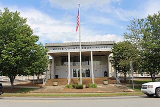
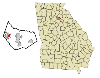
White County is a county located in the northeastern part of the U.S. state of Georgia. As of the 2020 census, the population was 28,003. The county seat is Cleveland. The county was created on December 22, 1857, formerly a part of Habersham County and most likely was named for Newton County Representative David T. White, who helped a Habersham representative successfully attain passage of an act creating the new county.

<span class="mw-page-title-main">Towns County, Georgia</span> County in Georgia, United States

Towns County is a county located in the northeastern part of the U.S. state of Georgia. As of the 2020 census, the population was 12,493. Its county seat is Hiawassee. The county was created on March 6, 1856, and named for lawyer, legislator, and politician George W. Towns.

<span class="mw-page-title-main">Hart County, Georgia</span> County in Georgia, United States

Hart County is a county located in the northeastern part of the U.S. state of Georgia. As of the 2020 census, the population was 25,828. The county seat is Hartwell.

<span class="mw-page-title-main">Falkville, Alabama</span> Town in Alabama, United States

Falkville is a town in Morgan County, Alabama, United States, and is included in the Decatur Metropolitan Area and Huntsville-Decatur Combined Statistical Area. As of the 2020 census, the population of the town was 1,197.

<span class="mw-page-title-main">Carl, Georgia</span> Town in Georgia, United States

Carl is a town in Barrow County, Georgia, United States. The population was 269 at the 2016 census.

<span class="mw-page-title-main">Canon, Georgia</span> City in Georgia, United States

Canon is a city in Franklin and Hart counties in the U.S. state of Georgia. The population was 804 at the 2010 census.

<span class="mw-page-title-main">Royston, Georgia</span> City in Georgia, United States

Royston is a city in Franklin, Hart, and Madison counties in the U.S. state of Georgia. The population was 2,649 at the 2020 census.

<span class="mw-page-title-main">Tallulah Falls, Georgia</span> Town in Georgia, United States

Tallulah Falls is a town in Habersham and Rabun counties in the U.S. state of Georgia near the Tallulah River. The population was 199 at the 2020 census.

<span class="mw-page-title-main">Arcade, Georgia</span> City in Georgia, United States

Arcade is a city in Jackson County, Georgia, United States. As of the 2020 census it had a population of 1,884.

<span class="mw-page-title-main">Hoschton, Georgia</span> City in Georgia, United States

Hoschton is a city in Jackson County, Georgia, United States. The population was 1,377 at the 2010 census. As of 2018 the estimated population was 1,916.

<span class="mw-page-title-main">Pendergrass, Georgia</span> City in Georgia, United States

Pendergrass is a city in Jackson County, Georgia, United States. The population was 1692 at the time of the 2020 census.

<span class="mw-page-title-main">Talmo, Georgia</span> Town in Georgia, United States

Talmo is a town in Jackson County, Georgia, United States. The population was 257 at the 2020 census.

<span class="mw-page-title-main">Carlton, Georgia</span> City in Georgia, United States

Carlton is a city in Madison County, Georgia, United States. The population was 263 at the 2020 census.

<span class="mw-page-title-main">Hull, Georgia</span> City in Georgia, United States

Hull is a city in Madison County, Georgia, United States. The population was 230 at the 2020 census, up from 198 in 2010.

<span class="mw-page-title-main">Avalon, Georgia</span> Town in Georgia, United States

Avalon is a town in Stephens County, Georgia, United States. As of the 2020 census, the city had a population of 233. Avalon was named for the Arthurian island of paradise. It was founded in 1882 by Richard Dempsey Yow, and incorporated in 1909. Yow and two brothers started a successful mercantile business there. Although it was at one time a self-contained village with a railway station, post office, school, and church, Avalon's tiny population now shares these functions with those dwelling in nearby towns.

<span class="mw-page-title-main">Frenchtown-Rumbly, Maryland</span> CDP in Maryland, United States

Frenchtown-Rumbly is a census-designated place in Somerset County, Maryland, United States. The population was 96 at the 2000 census. It is included in the Salisbury, Maryland-Delaware Metropolitan Statistical Area.

<span class="mw-page-title-main">Bowersville, Ohio</span> Village in Ohio, United States

Bowersville is a village in Greene County, Ohio, United States. The population was 261 at the 2020 census. It is part of the Dayton Metropolitan Statistical Area.

<span class="mw-page-title-main">Porter Township, Clarion County, Pennsylvania</span> Township in Pennsylvania, United States

Porter Township is a township in Clarion County, Pennsylvania, United States. The population was 1,287 at the 2020 census, a decrease from the figure of 1,348 tabulated in 2010.

<span class="mw-page-title-main">Gaskill Township, Jefferson County, Pennsylvania</span> Township in Pennsylvania, United States

Gaskill Township is a township in Jefferson County, Pennsylvania, United States. The population was 677 at the 2020 census. It was named for Charles C. Gaskill, agent of the Holland Land Company.

<span class="mw-page-title-main">Oakdale (town), Wisconsin</span> Town in Wisconsin, United States

Oakdale is a town in Monroe County, Wisconsin, United States. The population was 679 at the 2000 census. The Village of Oakdale is located within the town.

References

  1. "2020 U.S. Gazetteer Files". United States Census Bureau. Retrieved December 18, 2021.
  2. 1 2 "U.S. Census website". United States Census Bureau . Retrieved January 31, 2008.
  3. "US Board on Geographic Names". United States Geological Survey. October 25, 2007. Retrieved January 31, 2008.
  4. Acts and Resolutions of the General Assembly of the State of Georgia. Clark & Hines, State Printers. 1897. p. 133.
  5. Krakow, Kenneth K. (1975). Georgia Place-Names: Their History and Origins (PDF). Macon, GA: Winship Press. p. 23. ISBN   0-915430-00-2.
  6. "US Gazetteer files: 2010, 2000, and 1990". United States Census Bureau. February 12, 2011. Retrieved April 23, 2011.
  7. "Census of Population and Housing". Census.gov. Retrieved June 4, 2015.