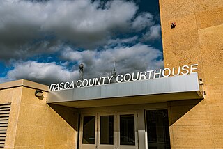
Itasca County is located in the State of Minnesota. As of the 2020 census, the population was 45,014. Its county seat is Grand Rapids. The county is named after Lake Itasca, which is in turn a shortened version of the Latin words veritas caput, meaning 'truth' and 'head', a reference to the source of the Mississippi River. Portions of the Bois Forte and Leech Lake Indian reservations are in the county.

The Leech Lake Reservation is an Indian reservation located in the north-central Minnesota counties of Cass, Itasca, Beltrami, and Hubbard. The reservation forms the land base for the federally recognized Leech Lake Band of Ojibwe, one of six bands comprising the Minnesota Chippewa Tribe, organized in 1934. The Leech Lake Reservation has the highest population of any reservation in Minnesota, with a resident population of 11,388 indicated by the 2020 census.

Chippewa National Forest is a National Forest located in north central Minnesota, United States, in the counties of Itasca, Cass and Beltrami. Forest headquarters are located in Cass Lake, Minnesota. There are local ranger district offices in Blackduck, Deer River and Walker.

The Minnesota Department of Natural Resources, or Minnesota DNR, is the agency of the U.S. state of Minnesota charged with conserving and managing the state's natural resources. The agency maintains areas such as state parks, state forests, recreational trails, and recreation areas as well as managing minerals, wildlife, and forestry throughout the state. The agency is divided into six divisions - Ecological & Water Resources, Enforcement, Fish & Wildlife, Forestry, Lands & Minerals, and Parks & Trails.
Ryan Village is an unincorporated community in Cass County, Minnesota, United States, within the Bowstring State Forest and the Chippewa National Forest. It is located between Cass Lake and Bena along U.S. Highway 2. The village is within the Leech Lake Indian Reservation.
The Fond du Lac State Forest is a state forest in Minnesota, United States, principally managed by the Minnesota Department of Natural Resources (MDNR). The main segment of the forest is located between the towns of Sawyer and Cromwell, in Carlton County. The boundaries of the forest overlap with those of the Fond du Lac Indian Reservation, some state forest land falls within the reservation. The Kettle Lake Wildlife Management Area is located in the southern half of the main segment. A smaller segment is located adjacent to Jay Cooke State Park and the border with Wisconsin in Saint Louis County.
The Crow Wing State Forest is a state forest located near Fairfield Township in Crow Wing County, Minnesota. It is about 20 miles (32 km) northeast of the tourism-based town of Brainerd. Approximately 14,072 acres (5,695 ha) (44%) of the forest of 31,307 acres (12,669 ha) is actively managed. The managed acres are split nearly equally between the Minnesota Department of Natural Resources, Crow Wing County, and the privately owned Potlatch Corp.
The Finland State Forest is a state forest located near the unincorporated community of Finland in Lake and Cook counties, Minnesota. Of the over 30,000 acres (12,000 ha), the Minnesota Department of Natural Resources manages a third of the land. The federal United States Forest Service manages roughly a quarter of the total forest acreage, as its boundary overlaps in part with that of Superior National Forest. The remainder is split between Cook and Lake County agencies, and private landowners.
The Badoura State Forest is a state forest located in Cass County and Hubbard County, Minnesota. 85% of the forest is managed by the Minnesota Department of Natural Resources, with the remaining 15% managed privately and by counties. Over half of the forest land is wetlands interspersed with Jack pine.
The Battleground State Forest is a state forest located near Gould Township in Cass County, Minnesota. It is managed by the Minnesota Department of Natural Resources. It lies entirely within the boundaries of the Chippewa National Forest, additionally, and a portion of the forest falls within the borders of the Leech Lake Indian Reservation.
The Beltrami Island State Forest is a state forest located in Lake of the Woods, Roseau, and Beltrami counties, Minnesota. Named after Italian explorer Giacomo Beltrami, it is the second-largest state forest in the Minnesota system after Pine Island State Forest. The largest wildlife management area in the state at 321,149 acres (129,964 ha), the Red Lake Wildlife Management Area, is located within the forest. The majority of the forest is managed by the Minnesota Department of Natural Resources, although a significant portion are tribal lands belonging to the neighboring Red Lake Band of Ojibwe.
The Buena Vista State Forest is a state forest located in Beltrami County, Minnesota. The Minnesota Department of Natural Resources manages 18,693 acres (7,565 ha) of state lands, with the majority of the forest split between private and other public ownership. The eastern half of the forest falls within the Chippewa National Forest, where Federal lands are managed by the United States Forest Service.

The Grand Portage State Forest is a state forest located near the community of Hovland in Cook County, in extreme northeastern Minnesota. The forest encloses Judge C. R. Magney State Park, Swamp River Wildlife Management Area, Hovland Woods Scientific and Natural Area, and Spring Beauty Hardwoods Scientific and Natural Area. It borders the Grand Portage Indian Reservation to the east, the Superior National Forest to the west, and Ontario to the north. The forest is named after the Grand Portage, a historic trade route between the Great Lakes and the Northwest.
The Insula Lake State Forest is a state forest located in Lake County, Minnesota. The forest is entirely within the limits of the Boundary Waters Canoe Area Wilderness of the Superior National Forest, and as such falls under the jurisdiction and management of the United States Forest Service.
The Kabetogama State Forest is a state forest located in Koochiching and Saint Louis counties, Minnesota, United States. The forest borders the Superior National Forest and the Boundary Waters Canoe Area Wilderness to the east, the Sturgeon River State Forest to the south, the Nett Lake Indian Reservation to the west, and Voyageurs National Park to the north. The forest is managed by the Minnesota Department of Natural Resources.
The Land o' Lakes State Forest is a state forest located primarily in Cass, Minnesota, with portions extending into adjacent Aitkin and Crow Wing counties. The forest has small shared borders with the Chippewa National Forest to the north, and the Hill River State Forest to east. Over half of the forest's land is managed by the Minnesota Department of Natural Resources; the remaining land is managed by Cass County or is privately held.
The Lost River State Forest is a state forest located in Roseau County, Minnesota. The forest borders the Canadian province of Manitoba to the north, and parcels belonging to the Red Lake Indian Reservation are within the forest's boundaries. The forest is managed by the Minnesota Department of Natural Resources.

Crescent Lake is a lake located in Tofte Township and Lutsen Township, Cook County, Minnesota.


