The Civilian Conservation Corps (CCC) was a voluntary government work relief program that ran from 1933 to 1942 in the United States for unemployed, unmarried men ages 18–25 and eventually expanded to ages 17–28. The CCC was a major part of President Franklin D. Roosevelt's New Deal that supplied manual labor jobs related to the conservation and development of natural resources in rural lands owned by federal, state, and local governments. The CCC was designed to supply jobs for young men and to relieve families who had difficulty finding jobs during the Great Depression in the United States. There was eventually a smaller counterpart program for unemployed women called the She-She-She Camps, which were championed by Eleanor Roosevelt.

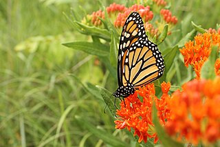
The monarch butterfly or simply monarch is a milkweed butterfly in the family Nymphalidae. Other common names, depending on region, include milkweed, common tiger, wanderer, and black-veined brown. It is among the most familiar of North American butterflies and an iconic pollinator, although it is not an especially effective pollinator of milkweeds. Its wings feature an easily recognizable black, orange, and white pattern, with a wingspan of 8.9–10.2 cm (3.5–4.0 in). A Müllerian mimic, the viceroy butterfly, is similar in color and pattern, but is markedly smaller and has an extra black stripe across each hindwing.

Asclepias is a genus of herbaceous, perennial, flowering plants known as milkweeds, named for their latex, a milky substance containing cardiac glycosides termed cardenolides, exuded where cells are damaged. Most species are toxic to humans and many other species, primarily due to the presence of cardenolides. However, as with many such plants, some species feed upon milkweed leaves or the nectar from their flowers. A noteworthy feeder on milkweeds is the monarch butterfly, which uses and requires certain milkweeds as host plants for their larvae.

Asclepias syriaca, commonly called common milkweed, butterfly flower, silkweed, silky swallow-wort, and Virginia silkweed, is a species of flowering plant. It is native to southern Canada and much of the United States east of the Rocky Mountains, excluding the drier parts of the prairies. It is in the genus Asclepias, the milkweeds. It grows in sandy soils as well as other kinds of soils in sunny areas.

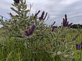
Asclepias incarnata, the swamp milkweed, rose milkweed, rose milkflower, swamp silkweed, or white Indian hemp, is a herbaceous perennial plant species native to North America. It grows in damp through wet soils and also is cultivated as a garden plant for its flowers, which attract butterflies and other pollinators with nectar. Like most other milkweeds, it has latex containing toxic chemicals, a characteristic that repels insects and other herbivorous animals.

Cascade River State Park is a state park near the northeastern tip of Minnesota, US. The park is in a rocky and rugged location where the Cascade River descends to meet Lake Superior. It has many different types of wildlife including various birds and mammals.

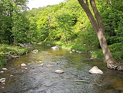
Wild River State Park is a state park of Minnesota, United States, curving along 18 miles (29 km) of the St. Croix River. This long, narrow park is shaped somewhat like a sideways 'S', with development largely concentrated in the lower third. The remote upper sections flank the mouth of a tributary called the Sunrise River. The park is managed to provide quieter, more nature-oriented recreation as a counterpoint to the busier William O'Brien and Interstate State Parks downstream.

Prairie Creek Redwoods State Park is a state park, located in Humboldt County, California, near the town of Orick and 50 miles (80 km) north of Eureka. The 14,000 acres (57 km2) park is a coastal sanctuary for old-growth Coast Redwood trees.

Flandrau State Park is a state park of Minnesota, United States, on the Cottonwood River adjacent to the city of New Ulm. Initially called Cottonwood River State Park, it was renamed in 1945 to honor Charles Eugene Flandrau, a leading citizen of early Minnesota who commanded defenses during the Battles of New Ulm in the Dakota War of 1862. The park was originally developed in the 1930s as a job creation project to provide a recreational reservoir. However the dam was repeatedly damaged by floods and was removed in 1995.

Fort Ridgely State Park is a state park of Minnesota, USA, on the Minnesota River south of Fairfax. It preserves Fort Ridgely, site of the Battle of Fort Ridgely during the Dakota War of 1862. It was the only Minnesota state park with a 9-hole golf course, which overlooks the Minnesota River and goes along Fort Ridgely Creek.

Scenic State Park is a Minnesota state park near Bigfork in Itasca County. It encompasses 3,936 acres (1,593 ha) of virgin pine forests that surround Sandwick Lake and Coon Lake. It also includes portions of Lake of the Isles, Tell Lake, Cedar Lake, and Pine Lake. Established in 1921, the Ojibwe tribe had previously used the area for hunting. The park has places for camping, hiking, swimming, fishing, and canoeing.

Lake Shetek State Park is a state park of Minnesota, United States, on Lake Shetek, which is the largest lake in southwestern Minnesota and the headwaters of the Des Moines River. It is most popular for water recreation and camping. However the park also contains historical resources related to the Dakota War of 1862, including an original log cabin and a monument to 15 white settlers killed there and at nearby Slaughter Slough on August 20, 1862.
Sibley State Park is a Minnesota state park near New London, on the shores of Andrew Lake. It is named for Henry Hastings Sibley, the first governor of the state. A city park in Mankato, Minnesota is also named for Sibley.
Butterfly gardening is a way to create, improve, and maintain habitat for lepidopterans including butterflies, skippers, and moths. Butterflies have four distinct life stages—egg, larva, chrysalis, and adult. In order to support and sustain butterfly populations, an ideal butterfly garden contains habitat for each life stage.

The Minnesota Department of Natural Resources, or Minnesota DNR, is the agency of the U.S. state of Minnesota charged with conserving and managing the state's natural resources. The agency maintains areas such as state parks, state forests, recreational trails, and recreation areas as well as managing minerals, wildlife, and forestry throughout the state. The agency is divided into six divisions - Ecological & Water Resources, Enforcement, Fish & Wildlife, Forestry, Lands & Minerals, and Parks & Trails.
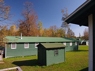
The Rabideau CCC Camp was a Civilian Conservation Corps (CCC) camp in the Chippewa National Forest in northern Minnesota, United States. It is located off Beltrami County Highway 39, in Taylor Township, and is one of the best-preserved of the nation's many CCC camps. A National Historic Landmark, it now serves as an educational center.

Asclepias meadii is a rare species of milkweed known by the common name Mead's milkweed. It is native to the American Midwest, where it was probably once quite widespread in the tallgrass prairie. Today much of the Midwest has been fragmented and claimed for agriculture, and the remaining prairie habitat is degraded.

Lake Ahquabi State Park is a state park in Warren County, Iowa, United States, featuring a 115-acre (47 ha) reservoir. Ahquabi means "resting place" in the Fox language. The park is 6 miles (9.7 km) south of Indianola and 22 miles (35 km) south of Des Moines. Three sections of the park were listed on the National Register of Historic Places in 1991.