Dinwiddie County is a county located in the Commonwealth of Virginia. As of the 2020 census, the population was 27,947. Its county seat is Dinwiddie.

Boydton is a town in Mecklenburg County, Virginia, United States. The population was 431 at the 2010 census. It is the county seat of Mecklenburg County, and it is near Kerr Lake.

Southside, or Southside Virginia, has traditionally referred to the portion of the state south of the James River, the geographic feature from which the term derives its name. This was the first area to be developed in the colonial period.
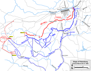
The Battle of Dinwiddie Court House was fought on March 31, 1865, during the American Civil War at the end of the Richmond-Petersburg Campaign and in the beginning stage of the Appomattox Campaign. Along with the Battle of White Oak Road which was fought simultaneously on March 31, the battle involved the last offensive action by General Robert E. Lee's Confederate Army of Northern Virginia attempting to stop the progress of Lieutenant General Ulysses S. Grant's Union Army. Grant's forces were moving to cut the remaining Confederate supply lines and to force the Confederates to extend their defensive lines at Petersburg, Virginia and Richmond, Virginia to the breaking point, if not to force them into a decisive open field battle.
The Battle of Lewis's Farm was fought on March 29, 1865, in Dinwiddie County, Virginia near the end of the American Civil War. In climactic battles at the end of the Richmond–Petersburg Campaign, usually referred to as the Siege of Petersburg, starting with Lewis's Farm, the Union Army commanded by Lieutenant General Ulysses S. Grant dislodged the Confederate Army of Northern Virginia commanded by General Robert E. Lee from defensive lines at Petersburg, Virginia and the Confederate capital of Richmond, Virginia. Many historians and the United States National Park Service consider the Battle of Lewis's Farm to be the opening battle of the Appomattox Campaign, which resulted in the surrender of Lee's army on April 9, 1865.
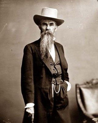
William Mahone was an American civil engineer, railroad executive, Confederate States Army general, and Virginia politician.
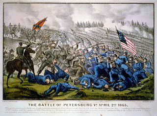
The Third Battle of Petersburg, also known as the Breakthrough at Petersburg or the Fall of Petersburg, was fought on April 2, 1865, south and southwest of Petersburg, Virginia, at the end of the 292-day Richmond–Petersburg Campaign and in the beginning stage of the Appomattox Campaign near the conclusion of the American Civil War. The Union Army under the overall command of General-in-Chief Lieutenant General Ulysses S. Grant, launched an assault on General Robert E. Lee's Confederate Army of Northern Virginia's Petersburg, Virginia trenches and fortifications after the Union victory at the Battle of Five Forks on April 1, 1865. As a result of that battle the Confederate right flank and rear were exposed. The remaining supply lines were cut and the Confederate defenders were reduced by over 10,000 men killed, wounded, taken prisoner or in flight.
The Battle of White Oak Road, also known as The Battle of Hatcher's Run, Gravelly Run, Boydton Plank Road, White Oak Ridge was fought on March 31, 1865, during the American Civil War at the end of the Richmond-Petersburg Campaign and in the beginning stage of the Appomattox Campaign. Along with the Battle of Dinwiddie Court House which was fought simultaneously on March 31, the battle involved the last offensive action by General Robert E. Lee's Confederate Army of Northern Virginia to stop the progress of Lieutenant General Ulysses S. Grant's Union Army. Grant's forces were moving to cut the remaining Confederate supply lines and to force the Confederates to extend their defensive lines at Petersburg, Virginia and Richmond, Virginia to the breaking point, if not to force them into a decisive open field battle.

The Appomattox campaign was a series of American Civil War battles fought March 29 – April 9, 1865, in Virginia that concluded with the surrender of Confederate General Robert E. Lee's Army of Northern Virginia to forces of the Union Army under the overall command of Lieutenant General Ulysses S. Grant, marking the effective end of the war.

The Battle of Peebles's Farm was the western part of a simultaneous Union offensive against the Confederate works guarding Petersburg and Richmond, Virginia, during the Siege of Petersburg in the American Civil War.

The Battle of the Boydton Plank Road, fought on October 27–28, 1864, followed the successful Battle of Peebles's Farm in the siege of Petersburg during the American Civil War. It was an attempt by the Union Army to seize the Boydton and Petersburg Plank Road and cut the South Side Railroad, a critical supply line to Petersburg, Virginia.

The Battle of Hatcher's Run, also known as Dabney's Mill, Armstrong's Mill, Rowanty Creek, and Vaughn Road, fought February 5–7, 1865, was one in a series of Union offensives during the siege of Petersburg, aimed at cutting off Confederate supply traffic on Boydton Plank Road and the Weldon Railroad west of Petersburg, Virginia.

U.S. Route 1 (US 1) is a major north–south U.S. Highway that serves the East Coast of the United States. In the U.S. state of Virginia, US 1 runs north–south through South Hill, Petersburg, Richmond, Fredericksburg, and Alexandria on its way from North Carolina to the 14th Street Bridge into the District of Columbia. It is completely paralleled by Interstate Highways in Virginia – Interstate 85 (I-85) south of Petersburg, I-95 north to Alexandria, and I-395 into the District of Columbia – and now serves mainly local traffic. At its north end, on the approach to the 14th Street Bridge, US 1 is concurrent with I-395; the rest of US 1 is on surface roads.

State Route 49 is a primary state highway in the U.S. state of Virginia. The state highway runs 69.01 miles (111.06 km) from the North Carolina state line in Virgilina, Virginia in Halifax County, where the highway continues south as North Carolina Highway 49, north to U.S. Route 360 near Burkeville in Nottoway County. SR 49 passes through Southside Virginia, connecting Virgilina and Burkeville with Clarksville and Chase City in Mecklenburg County, Victoria in Lunenburg County, and Crewe in Nottoway County. Via US 360, the state highway connects Richmond with the John H. Kerr Reservoir.

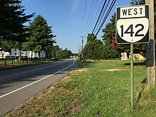
State Route 142 is a primary state highway in the U.S. state of Virginia. The state highway runs 2.73 miles (4.39 km) from U.S. Route 1 and US 460 Business near Petersburg to the highway's crossing of a CSX rail line in the independent city of Petersburg.

State Route 226 is a primary state highway in the U.S. state of Virginia. Known as Cox Road, the state highway runs 3.38 miles (5.44 km) from U.S. Route 460 near Sutherland east to US 1 and US 460 Business near Petersburg. SR 226 is the old alignment of US 460 in northeastern Dinwiddie County.
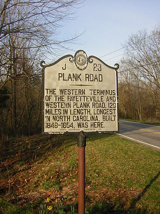
The Fayetteville and Western Plank Road was a 129 mi (208 km) plank road from Fayetteville, NC to the Moravian settlement at Bethania, NC. The road was constructed from 1851-1852 using funds raised by boosters and accompanying funds provided by the state of North Carolina.
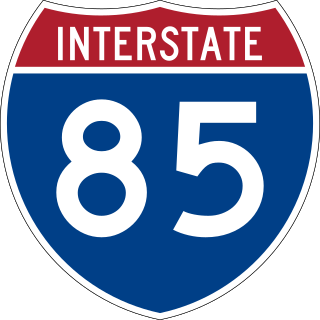
Interstate 85 (I-85) is a part of the Interstate Highway System that runs from Montgomery, Alabama, to Petersburg, Virginia. In Virginia, the Interstate Highway runs 68.64 miles (110.47 km) from the North Carolina state line near Bracey north to I-95 in Petersburg. I-85 passes through the eastern part of Southside, where it parallels US Route 1 (US 1) from Petersburg, where the highway runs concurrently with US 460, to south of South Hill, where the highway intersects Southside's major east–west highway, US 58. The Interstate Highway is the primary connection between the Greater Richmond Region and Research Triangle and other major metropolitan areas of North Carolina. Like all mainline Interstate Highways, I-85 is a part of the National Highway System for its entire length in Virginia.
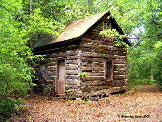
Patrick Robert "Parker" Sydnor Log Cabin sits on a historic site located in Clarksville, Virginia. The construction of the cabin suggests that it was built during the antebellum period. A 1+1⁄2-story log building with a gable roof, the cabin consists of one room with a loft above, and a brick and stone chimney. Also found on the northwest side of the property is a wood storage shed, a chicken house, and an outhouse, dating from around 1930.

Pamplin Historical Park is a 424-acre private sector historical park located near Petersburg, Virginia. The park preserves open space near Richmond, Virginia in Dinwiddie County, Virginia and serves the dual use of preserving a significant fragment of the Petersburg Breakthrough Battlefield, a National Historic Landmark, and key components of the Third Battle of Petersburg. The park also provides a footprint location for the National Museum of the Civil War Soldier, which is located within the park.