Mecklenburg County, Virginia

Last updated

Mecklenburg County
Mecklenburg County Courthouse.JPG
Mecklenburg Seal.jpg
Map of Virginia highlighting Mecklenburg County.svg
Location within the U.S. state of Virginia
Virginia in United States.svg
Virginia's location within the U.S.
Coordinates: 36°41′N78°22′W / 36.68°N 78.37°W / 36.68; -78.37
CountryFlag of the United States.svg United States
StateFlag of Virginia.svg  Virginia
Founded1765
Named for Charlotte of Mecklenburg-Strelitz
Seat Boydton
Largest town South Hill
Area
  Total679 sq mi (1,760 km2)
  Land625 sq mi (1,620 km2)
  Water54 sq mi (140 km2)  7.9%
Population
 (2020)
  Total30,319
  Density45/sq mi (17/km2)
Time zone UTC−5 (Eastern)
  Summer (DST) UTC−4 (EDT)
Congressional district 5th
Website www.mecklenburgva.com
Queen Charlotte of Mecklenburg, the county's namesake Charlotte Mecklenburg.JPG
Queen Charlotte of Mecklenburg, the county's namesake

Mecklenburg County is a county in the Commonwealth of Virginia. As of the 2020 census, the population was 30,319. [1] Its county seat is Boydton. [2]

Contents

History

Mecklenburg County was organized on March 1, 1765, having split from Lunenburg County in 1764 as the result of the passage of an act by the Virginia General Assembly. Due to new settlement and population increases in the area, the legislature divided Lunenburg into three counties: Lunenburg, Charlotte County, and Mecklenburg. [3] It was named after Charlotte of Mecklenburg-Strelitz, [4] a British queen of German origin.

The first county government consisted of 13 members: Robert Munford, Richard Witton, John Speed, Henry Delony, Edmund Taylor, Benjamin Baird, John Camp, Thomas Erskine, John Potter, John Cox, Thomas Anderson, John Speed, Jr., and Samuel Hopkins, with Benjamin Baird acting as the first mayor. [3]

Government

Mecklenburg County is governed by a nine-member Board of Supervisors, each elected from a single-member district. They serve as the county's legislative and policy body, enacting laws, ordinances, and taxes. They appoint a county administrator to conduct day-to-day operations. H. Wayne Carter, III is the current county administrator and Judy P. Sheffield is the current assistant county administrator.

The board members are: [5]

Constitutional officers

Under the Virginia Constitution, each county and city in the state must install constitutional officers. Counties under the Traditional Form of Government must install all five officers. The majority of Virginia counties operate under the Traditional Form. Counties with the County Executive Form, Urban County Executive, or County Manager Plan of Government usually install just three (Clerk, Commonwealth Attorney, and Sheriff), opting for a Director of Finance appointed by the Board to take the place of the Commissioner of Revenue and Treasurer. Examples are Fairfax, Henrico and Prince William Counties. These officers are heads of their respective departments. They consist of:

These offices are currently held by:

County departments and department heads

Listed below are the County facilities, the department housed in that facility and its head.

Politics

United States presidential election results for Mecklenburg County, Virginia [6]
Year Republican Democratic Third party
No.%No.%No.%
2020 9,26657.18%6,80341.98%1350.83%
2016 8,28855.46%6,28542.05%3722.49%
2012 7,97352.88%6,92145.90%1831.21%
2008 7,81751.83%7,12747.26%1380.91%
2004 7,31957.27%5,29341.42%1681.31%
2000 6,60056.63%4,79741.16%2572.21%
1996 4,93348.00%4,40842.89%9379.12%
1992 5,40149.23%4,27338.95%1,29611.81%
1988 5,88763.45%3,27535.30%1161.25%
1984 6,77765.69%3,43833.33%1010.98%
1980 4,85354.45%3,79042.52%2703.03%
1976 4,42350.44%4,07646.48%2703.08%
1972 6,38168.55%2,80430.12%1241.33%
1968 2,75029.01%2,66728.14%4,06142.85%
1964 4,97660.48%3,23839.36%130.16%
1960 1,93642.70%2,53355.87%651.43%
1956 1,49833.78%2,00445.20%93221.02%
1952 1,89142.46%2,52556.69%380.85%
1948 51316.80%2,11769.34%42313.86%
1944 43014.38%2,56185.62%00.00%
1940 30811.35%2,40288.54%30.11%
1936 2026.88%2,73093.05%20.07%
1932 27511.10%2,18888.30%150.61%
1928 78430.91%1,75269.09%00.00%
1924 28614.62%1,64984.30%211.07%
1920 26413.97%1,61985.66%70.37%
1916 22214.38%1,31785.30%50.32%
1912 19114.39%1,03978.30%977.31%

Education

The county's education department is the Mecklenburg County Public Schools. It is managed by the Board of Education. Paul Nichols is the County Schools Superintendent.

Geography

According to the U.S. Census Bureau, the county has an area of 679 square miles (1,760 km2), of which 625 square miles (1,620 km2) is land and 54 square miles (140 km2) (7.9%) is water. [7]

Adjacent counties

Major highways

Demographics

Historical population
CensusPop.Note
1790 14,733
1800 17,00815.4%
1810 18,4538.5%
1820 19,7867.2%
1830 20,4773.5%
1840 20,7241.2%
1850 20,630−0.5%
1860 20,096−2.6%
1870 21,3186.1%
1880 24,61015.4%
1890 25,3593.0%
1900 26,5514.7%
1910 28,9569.1%
1920 31,2087.8%
1930 32,6224.5%
1940 31,933−2.1%
1950 33,4974.9%
1960 31,428−6.2%
1970 29,426−6.4%
1980 29,4440.1%
1990 29,241−0.7%
2000 32,28010.4%
2010 32,7271.4%
2020 30,319−7.4%
U.S. Decennial Census [8]
1790-1960 [9] 1900-1990 [10]
1990-2000 [11] 2010 [12] 2020 [13]

2020 census

Mecklenburg County, Virginia – Racial and ethnic composition
Note: the US Census treats Hispanic/Latino as an ethnic category. This table excludes Latinos from the racial categories and assigns them to a separate category. Hispanics/Latinos may be of any race.
Race / Ethnicity (NH = Non-Hispanic)Pop 2010 [12] Pop 2020 [13] % 2010% 2020
White alone (NH)19,21517,86458.71%58.92%
Black or African American alone (NH)11,95810,36436.54%34.18%
Native American or Alaska Native alone (NH)73730.22%0.24%
Asian alone (NH)2132050.65%0.68%
Pacific Islander alone (NH)1000.03%0.00%
Some Other Race alone (NH)221100.07%0.36%
Mixed Race or Multi-Racial (NH)4308821.31%2.91%
Hispanic or Latino (any race)8068212.46%2.71%
Total32,72730,319100.00%100.00%

2010 Census

As of the census [14] of 2010, there were 32,727 people, 12,951 households, and 8,962 families residing in the county. The population density was 52 people per square mile (20 people/km2). There were 17,403 housing units at an average density of 28 units per square mile (11 units/km2). The racial makeup of the county was 59.24% White, 39.08% Black or African American, 0.21% Native American, 0.30% Asian, 0.01% Pacific Islander, 0.48% from other races, and 0.68% from two or more races. 1.21% of the population were Hispanic or Latino of any race.

There were 12,951 households, out of which 26.50% had children under the age of 18 living with them, 51.00% were married couples living together, 14.10% had a female householder with no husband present, and 30.80% were non-families. 27.20% of all households were made up of individuals, and 13.20% had someone living alone who was 65 years of age or older. The average household size was 2.38 and the average family size was 2.87.

In the county, the population was spread out, with 21.60% under the age of 18, 7.20% from 18 to 24, 27.40% from 25 to 44, 26.00% from 45 to 64, and 17.80% who were 65 years of age or older. The median age was 41 years. For every 100 females there were 97.30 males. For every 100 females age 18 and over, there were 96.50 males.

The median income for a household in the county was $31,380, and the median income for a family was $37,752. Males had a median income of $26,852 versus $19,609 for females. The per capita income for the county was $17,171. About 11.60% of families and 15.50% of the population were below the poverty line, including 20.60% of those under age 18 and 17.30% of those age 65 or over.

Communities

Towns

Census-designated places

Other unincorporated communities

See also

Related Research Articles

<span class="mw-page-title-main">Gadsden County, Florida</span> County in Florida, United States

Gadsden County is a county located in the panhandle of the U.S. state of Florida. As of the 2020 census, the population was 43,826. Its county seat is Quincy. Gadsden County is included in the Tallahassee, FL Metropolitan Statistical Area. Gadsden County is the only majority African-American county in Florida.

<span class="mw-page-title-main">Okeechobee County, Florida</span> County in Florida, United States

Okeechobee County is a county located in the Florida Heartland region of the state of Florida. As of the 2020 census, the population was 39,644. The county seat is Okeechobee.

<span class="mw-page-title-main">Greene County, Virginia</span> County in Virginia, United States

Greene County is a county in Virginia in the eastern United States. As of the 2020 census, the population was 20,552. Its county seat is Stanardsville.

<span class="mw-page-title-main">Wythe County, Virginia</span> County in Virginia, United States

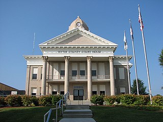
Wythe County is a county located in the southwestern part of the U.S. state of Virginia. As of the 2020 census, the population was 28,290. Its county seat is Wytheville.

<span class="mw-page-title-main">Pittsylvania County, Virginia</span> County in Virginia, United States

Pittsylvania County is a county located in the Commonwealth of Virginia. As of the 2020 United States Census, the population was 60,501. Chatham is the county seat.

<span class="mw-page-title-main">Northumberland County, Virginia</span> County in Virginia, United States

Northumberland County is a county located in the Commonwealth of Virginia. At the 2020 census, the population was 11,839. Its county seat is Heathsville. The county is located on the Northern Neck and is part of the Northern Neck George Washington Birthplace AVA winemaking appellation.

<span class="mw-page-title-main">Lunenburg County, Virginia</span> County in Virginia, United States

Lunenburg County is a county located in the Commonwealth of Virginia. As of the 2020 census, the population was 11,936. Its county seat is Lunenburg.

<span class="mw-page-title-main">Lancaster County, Virginia</span> County in Virginia, United States

Lancaster County is a county located on the Northern Neck in the Commonwealth of Virginia. As of the 2020 census, the population sits at 10,919. Its county seat is Lancaster.

<span class="mw-page-title-main">Henry County, Virginia</span> County in Virginia, United States

Henry County is a county located in the U.S. state of Virginia. As of the 2020 census, the population was 50,948. The county seat is usually identified as Martinsville; however, the administration building, county courthouse, and Henry County Sheriff's Office are located on Kings Mountain Road in Collinsville.The Henry County Adult Detention Center is located on DuPont Road in Martinsville.

<span class="mw-page-title-main">Halifax County, Virginia</span> County in Virginia, United States

Halifax County is a county located in the Commonwealth of Virginia. As of the 2020 census, the population was 34,022. Its county seat is Halifax.

<span class="mw-page-title-main">Fauquier County, Virginia</span> County in Virginia, United States

Fauquier County is a county in the Commonwealth of Virginia. As of the 2020 census, the population was 72,972. The county seat is Warrenton.

<span class="mw-page-title-main">Cumberland County, Virginia</span> County in Virginia, United States

Cumberland County is a county located in the Commonwealth of Virginia, United States. As of the 2020 census, the population was 9,675. Its county seat is Cumberland.

<span class="mw-page-title-main">Craig County, Virginia</span> County in Virginia, United States

Craig County is a county located in the Commonwealth of Virginia. As of the 2020 census, the population was 4,892. Its county seat is New Castle.

<span class="mw-page-title-main">Charlotte County, Virginia</span> County in Virginia, United States

Charlotte County is a United States county located in the south central part of the Commonwealth of Virginia. Its county seat is the town of Charlotte Court House. As of the 2020 census, the county population was 11,529. Charlotte County is predominantly rural with a population density of only 26.5 persons per square mile.

<span class="mw-page-title-main">Brunswick County, Virginia</span> County in Virginia, United States

Brunswick County is a United States county located on the southern border of the Commonwealth of Virginia. This rural county is known as one of the claimants to be the namesake of Brunswick stew. Brunswick County was created in 1720 from parts of Prince George, Surry and Isle of Wight counties. The county was named for the former Duchy of Brunswick-Lunenburg, the region from which the British monarchs of the House of Hanover originated. As of the 2020 census, the county population was 15,849. The Brunswick county seat is Lawrenceville.

<span class="mw-page-title-main">Bland County, Virginia</span> County in Virginia, United States

Bland County is a county located in the southwestern portion of the Commonwealth of Virginia. The county seat is the unincorporated area of Bland. At the 2020 census, the population was 6,270.

<span class="mw-page-title-main">Bedford County, Virginia</span> County in Virginia, United States

Bedford County is a United States county located in the Piedmont region of the Commonwealth of Virginia. Its county seat is the town of Bedford, which was an independent city from 1968 until rejoining the county in 2013.

<span class="mw-page-title-main">Augusta County, Virginia</span> County in Virginia, United States

Augusta County is a county in the Shenandoah Valley on the western edge of the Commonwealth of Virginia in the United States. The second-largest county of Virginia by total area, it completely surrounds the independent cities of Staunton and Waynesboro. Its county seat is Staunton, but most of the administrative services have offices in neighboring Verona.

<span class="mw-page-title-main">Alleghany County, Virginia</span> County in Virginia, United States

Alleghany County is an American county located on the far western edge of Commonwealth of Virginia. It is bordered by the Allegheny Mountains, from which the county derives its name, and it is the northernmost part of the Roanoke Region. The county seat is Covington. As of the 2020 census, the population was 15,223.

<span class="mw-page-title-main">King William County, Virginia</span> County in Virginia, United States

King William County is a county located in the U.S. state of Virginia. As of the 2020 census, the population was 17,810. Its county seat is King William.

References

  1. "Mecklenburg County, North Carolina". United States Census Bureau . Retrieved January 30, 2022.
  2. "Find a County". National Association of Counties. Retrieved June 7, 2011.
  3. 1 2 Bracey, S. (1977). Life by the Roaring Roanoke, Whittet and Shepperson.
  4. Gannett, Henry (1905). The Origin of Certain Place Names in the United States. U.S. Government Printing Office. p. 204.
  5. "Board of Supervisors | Mecklenburg County, VA".
  6. Leip, David. "Dave Leip's Atlas of U.S. Presidential Elections". uselectionatlas.org. Retrieved December 9, 2020.
  7. "US Gazetteer files: 2010, 2000, and 1990". United States Census Bureau. February 12, 2011. Retrieved April 23, 2011.
  8. "Census of Population and Housing from 1790-2000". US Census Bureau . Retrieved January 24, 2022.
  9. "Historical Census Browser". University of Virginia Library. Retrieved January 3, 2014.
  10. "Population of Counties by Decennial Census: 1900 to 1990". United States Census Bureau. Retrieved January 3, 2014.
  11. "Census 2000 PHC-T-4. Ranking Tables for Counties: 1990 and 2000" (PDF). United States Census Bureau. Archived (PDF) from the original on October 9, 2022. Retrieved January 3, 2014.
  12. 1 2 "P2 Hispanic or Latino, and Not Hispanic or Latino by Race – 2010: DEC Redistricting Data (PL 94-171) - Mecklenburg County, North Carolina". United States Census Bureau .
  13. 1 2 "P2 Hispanic or Latino, and Not Hispanic or Latino by Race – 2020: DEC Redistricting Data (PL 94-171) - Mecklenburg County, North Carolina". United States Census Bureau .
  14. "U.S. Census website". United States Census Bureau . Retrieved May 14, 2011.

36°41′N78°22′W / 36.68°N 78.37°W / 36.68; -78.37