Boyne Burnett Inland Rail Trail

Last updated

The Boyne Burnett Inland Rail Trail is a recreational route for walkers, cyclists and horse riders from Taragoola (near Calliope) to Gayndah. It uses the closed Gladstone to Monto and Mungar Junction to Monto railway corridors in Queensland, Australia. [1] [2] [3]

Contents

Route

Only two sections of the Trail have been opened, up to September 2022. The Burnett River Bridges section is 170 kilometres (110  mi ) south of the Dawes Range Tunnel section. Waterways may be impassable after rain, as the bridges are not usable. [4]

Dawes Range Tunnel section

The 26.28- kilometre (16.33  mi ) Dawes Range Tunnel section starts at Barrimoon Siding, Kalpowar and finishes at Builyan, Boyne Valley. [5] This section contains 6 tunnels between Barrimoon Siding and Golembil Siding. [6] [7] Between Barrimoon Siding to Golembil Siding through the Dawes Range there are also views of mountains and both cuttings and tunnels to see. The trail also passes the historic township of Many Peaks with its Local Heritage listed attractions. Camping before the start is available in Kalpowar State Forest at Kalpowar camping area (Gladstone) or in Pine Street, Kalpowar. Camping is available in Builyan at the finish. [8]

Humphery Railway Bridge, also known as Faith Bridge Rail Bridge (Humphery), Gayndah (2002).jpg
Humphery Railway Bridge, also known as Faith Bridge

Burnett River Bridges section

Heading west from the Trail head at Mt Debateable Railway Siding, Mt Debateable Road, Gayndah, the Burnett River Bridges section traverses 30.4 kilometres (18.9 mi). [9] The Red Gulley Bridge, Slab Creek Bridge, Spring Creek Bridge, Boomerang Bridge, Humphery Bridges Numbers 1, 2 ("Faith" Bridge or "bridge of faith") and 3 and Roth's Bridge are passed on the way to Mundubbera. [10]

Heading east from the Trail head are the remains of Reids Ck Bridge. The distance is a total of 14.2 kilometres (8.8 mi), there and back. [9]

Optionally the 23.34-kilometre (14.50 mi) Sleeping Giant Loop Trail leaves the Reid Creek trail at Dirnbir siding and goes along Dirnbir Road and Mt Debateable Road to return to the Trail head. [9] The Loop Trail includes a diversion to McConnell Lookout and Park along Renay Robinson Dve, which has a gradient of 12%. Facilities at the Lookout include public toilets, sheltered picnic tables, a fire pit, rubbish bins, car park, and information. [11]

Geography

Dawes Range Tunnel section

The Dawes Range Tunnel section starts in the Boyne River Valley. It passes through the Glassford State Forest and the Dawes Range, and finishes in Barrimoon which adjoins Kalpowar State Forest. It crosses Glassford Creek which is a tributary of the Boyne River, and Coppermine and Boggy Creeks which are tributaries of Glassford Creek. [5]

Riverside Walk and Burnett River at Mundubbera MundubberaRiversideWalk.JPG
Riverside Walk and Burnett River at Mundubbera

The Boyne River drainage sub-basin contains the towns of Barmundi, Benaraby, Boyne Island, Boynedale, Builyan, Golembil, Little More, Many Peaks, Nagoorin, Rodds Bay, Tannum Sands, Taragoola, Ubobo and Wietalaba. [12] This drainage sub-basin should not be confused with the Boyne & Auburn Rivers drainage sub-basin which drains into the Burnett River west of Mundubbera. [13]

Burnett River Bridges section

The Burnett River Bridges section passes through a region of citrus orchards. [14] Sixteen kilometres of it lies beside the Burnett River on one side, and the slopes leading up to the southern end of the Binjour Plateau on the other side. The Burnett River drains a basin covering 33,210 square kilometres (12,820  sq mi ) - 1.9% of the total area of Queensland. [15]

The Queensland lungfish, a living fossil, can live for several days out of the water if it is kept moist, and is native to the Burnett River. [3] While lungfish and platypus would be rare sightings, koalas might be spotted in the eucalypt forest beside the trail. [4]

History

From 2012, conversion of the corridor to a multi-use rail trail was discussed. Boyne Burnett Inland Rail Trail was incorporated in July 2018 and its stated goal was to "attract increasingly significant visitor numbers to the Trail and adjacent communities in coming years". [16] Soon afterwards a $99,000 feasibility study was fully funded through the Queensland Government's Queensland Cycling Action Plan. [17]

Gladstone Regional Council and North Burnett Regional Council received the Final Report in March 2019. [18] Subsequently concept designs and a draft master plan were drawn up and extensive community engagement was undertaken. [1] [2]

The Dawes Range Tunnel section of the Boyne Burnett Inland Rail Trail was opened on 11 September 2021. [19]

The Burnett River Bridges section of the Boyne Burnett Inland Rail Trail was opened on 10 September 2022. [20]

Heritage listing

Many Peaks Railway Dam, completed in 1912. Many Peaks Railway Dam 002.JPG
Many Peaks Railway Dam, completed in 1912.

The Queensland Heritage Register listed

The Local Heritage Register of Gladstone Regional Council listed

The Official Register of Engineering Heritage Markers listed

See also

Related Research Articles

<span class="mw-page-title-main">Mundubbera</span> Town in Queensland, Australia

Mundubbera is a town and a locality in the North Burnett Region, Queensland, Australia. In the 2016 census, Mundubbera had a population of 1261 people.

<span class="mw-page-title-main">Boyne Valley, Queensland</span> Suburb of Gladstone Region, Queensland, Australia

The Boyne Valley is a rural locality in Gladstone Region, Queensland, Australia. The locality contains four small towns: Nagoorin, Ubobo, Builyan, and Many Peaks. In the 2021 census, Boyne Valley had a population of 301 people.

<span class="mw-page-title-main">Builyan, Queensland</span> Town in Queensland, Australia

Builyan is a town in Gladstone Region, Central Queensland, Australia. It is one of four small townships within the locality of Boyne Valley along with Nagoorin, Ubobo, and Many Peaks.

<span class="mw-page-title-main">Many Peaks, Queensland</span> Town in Queensland, Australia

Many Peaks is a town in Gladstone Region in Queensland, Australia. It is one of four small townships within the locality of Boyne Valley along with Nagoorin, Builyan and Ubobo.

<span class="mw-page-title-main">Gladstone Region</span> Local government area in Queensland, Australia

Gladstone Region is a local government area in Queensland, Australia. The council covers an area of 10,484 square kilometres (4,048 sq mi), had a resident population at August 2021 of 63,515, and has an estimated operating budget of A$84 million.

<span class="mw-page-title-main">Nanango railway line</span> Former railway line in Queensland, Australia

The Nanango railway line was a narrow-gauge branch railway located in Queensland, Australia. On 31 October 1882, parliament approved the construction of a branch line from Theebine west to Kilkivan after gold and copper were discovered in this region of Queensland, Australia. The section was opened in two stages – to Dickabram on 1 January 1886 after two crossings of the Mary River and to Kilkivan on 6 December 1886.

<span class="mw-page-title-main">Mungar Junction to Monto railway line</span> Former railway line in Queensland, Australia

The Mungar Junction to Monto railway line is a 267-kilometre (166 mi) railway in Queensland, Australia. Progressively opened in eleven stages between 1889 and 1928 the line branched from the North Coast line at Mungar Junction a short distance west of Maryborough and followed a westerly route towards Biggenden and Gayndah before turning north via Mundubbera and Eidsvold to Monto. It is also known as the Gayndah Monto Branch Railway. In 2012, the line was officially closed.

Byellee to Monto Branch Railway was a branch railway that branched off the Boyne Valley west of Gladstone in Queensland, Australia.The Boyne Valley region was predominantly a dairying region and a railway had little justification. However a branch was justified in 1906 on the basis of large traffic in timber, fuel, limestone and flexing ores. Progressively opened between 1910 and 1931 the line branched from the North Coast line at Byellee a short distance west of Gladstone and struck a south-westerly route via Many Peaks and Mungungo to Monto.

<span class="mw-page-title-main">Degilbo</span> Town in Queensland, Australia

Degilbo is a rural town and locality in the North Burnett Region, Queensland, Australia. In the 2016 census, the locality of Degilbo had a population of 174 people.

<span class="mw-page-title-main">Didcot, Queensland</span> Suburb of North Burnett Region, Queensland, Australia

Didcot is a rural locality in the North Burnett Region, Queensland, Australia. In the 2016 census Didcot had a population of 60 people.

<span class="mw-page-title-main">Deep Creek Railway Bridge</span> Historic site in Queensland, Australia

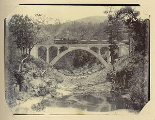
Deep Creek Railway Bridge is also known as Chowey Bridge. It is a heritage-listed railway bridge on the Mungar-Monto railway line in Didcot, North Burnett Region, Queensland, Australia. It was built in 1905 by day labour. It was added to the Queensland Heritage Register on 21 October 1992.

<span class="mw-page-title-main">William Pagan (railway engineer)</span> Australian railway engineer

William Pagan (1849–1924) was a railway engineer in Queensland, Australia. He designed many railway bridges, some of which are now heritage-listed.

<span class="mw-page-title-main">Steep Rocky Creek Railway Bridge</span> Railway bridge in Queensland, Australia.

Steep Rocky Creek Railway Bridge is a heritage-listed railway bridge on the Mungar - Monto railway line at Ideraway in the North Burnett Region of Queensland, Australia. It was designed by William Pagan and built from 1906 to 1907. It was added to the Queensland Heritage Register on 21 October 1992.

<span class="mw-page-title-main">Ideraway Creek Railway Bridge</span> Historic site in Queensland, Australia

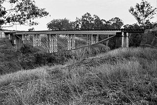
Ideraway Creek Railway Bridge is a heritage-listed railway bridge at Mungar - Monto Line, Ideraway, North Burnett Region, Queensland, Australia. It was designed by William Pagan and built from 1906 to 1907 using day labour. It was added to the Queensland Heritage Register on 21 October 1992.

<span class="mw-page-title-main">Humphery Railway Bridge</span> Historic site in Queensland, Australia

Humphery Railway Bridge is a heritage-listed railway bridge on the Mungar to Monto railway line at Humphery, North Burnett Region, Queensland, Australia. It was designed by William Pagan and built in 1913. It was added to the Queensland Heritage Register on 21 October 1992.

<span class="mw-page-title-main">Kalpowar</span> Town in Queensland, Australia

Kalpowar is a town in the North Burnett Region and a locality split between the North Burnett Region and the Bundaberg Region, in Queensland, Australia. In the 2016 census, the locality of Kalpowar had a population of 67 people.

Dirnbir is a rural locality in the North Burnett Region, Queensland, Australia. In the 2021 census, Dirnbir had a population of 59 people.

Mount Lawless is a rural locality in the North Burnett Region, Queensland, Australia. In the 2021 census, Mount Lawless had a population of 9 people.

Gladstone–Monto Road is a 132 kilometres (82 mi) road route in the Gladstone and North Burnett regions of Queensland, Australia. The entire route is signed as State Route 69.

References

  1. 1 2 Gladstone Regional Council (2022). "Boyne Burnett Inland Rail Trail (BBIRT)". Conversations with Council. Retrieved 6 October 2022.
  2. 1 2 SarahNBRC4625; North Burnett Regional Council (22 March 2019). "Boyne Burnett Inland Rail Trail Development Program". North Burnett Regional Council. Retrieved 6 October 2022.{{cite web}}: CS1 maint: numeric names: authors list (link)
  3. 1 2 Marsellos, Brad (11 September 2022). "Hunt for a 'living dinosaur' as new rail trail reconnects historic Queensland towns". ABC News Australia . Retrieved 6 October 2022.
  4. 1 2 3 Trail Guide. "Trail - Boyne Burnett Inland Rail Trail". Rail Trails Australia. Retrieved 15 October 2022.
  5. 1 2 McLachlan, Mark (20 August 2022). "Interactive Maps, Dawes Range Section, BBIRT". Boyne Burnett Inland Rail Trail. Retrieved 28 September 2022.
  6. McLachlan, Mark (19 June 2018). "Railway Tunnels, Dawes Range between Golembil and Barrimoon sidings". Boyne Burnett Inland Rail Trail. Retrieved 28 September 2022 via Blog.
  7. Billing, Amy. "Local Heritage Register". Gladstone Regional Council. Many Peaks / Barrimoon Railway Tunnels. Retrieved 28 September 2022.
  8. "Kalpowar Camping Area - Kalpowar State Forest (CG)". Full Range Camping Directory. Retrieved 14 October 2022.
  9. 1 2 3 McLachlan, Mark (7 September 2022). "Interactive Maps, Burnett River Bridges Section, BBIRT". Boyne Burnett Inland Rail Trail. Retrieved 14 October 2022.
  10. "Mt Debateable to Mundubbera, Burnett River Bridges Section, BBIRT". Boyne Burnett Inland Rail Trail. Retrieved 25 September 2022.
  11. "McConnell Lookout & Park - Renay Robinson Dve, Dirnbir, QLD » POI Australia". poi-australia.com.au. Retrieved 14 October 2022.
  12. Department of Environment and Science, Queensland Government (2013). "Boyne River drainage sub-basin — facts and maps". wetlandinfo.des.qld.gov.au. Retrieved 9 October 2022.
  13. Department of Environment and Science, Queensland Government (2013). "Boyne & Auburn Rivers drainage sub-basin — facts and maps". wetlandinfo.des.qld.gov.au. Retrieved 9 October 2022.
  14. Council, North Burnett Regional. "Industry Focus". North Burnett Regional Council . Retrieved 15 October 2022.
  15. Department of Environment and Science, Queensland Government (2013). "Burnett drainage basin — facts and maps". wetlandinfo.des.qld.gov.au. Retrieved 9 October 2022.
  16. "About Us". Boyne Burnett Inland Rail Trail. Retrieved 6 October 2022.
  17. Colahan, Mackenzie (19 September 2018). "'Major breakthrough' announced for rail trail". Central and North Burnett Times. The Courier-Mail . Retrieved 6 October 2022.
  18. Gladstone Regional Council; North Burnett Regional Council (March 2019). "BOYNE BURNETT INLAND RAIL TRAIL FINAL REPORT" (PDF). Boyne Burnett Inland Rail Trail. Retrieved 6 October 2022.
  19. RTA News (3 October 2021). "BOYNE BURNETT RAIL TRAIL – OPENING THE DAWES RANGE SECTION". Rail Trails Australia. Retrieved 15 October 2022.
  20. RTA News (10 July 2022). "Opening of the Burnett River Bridges section of the Boyne Burnett Inland Rail Trail". Rail Trails Australia. Retrieved 25 September 2022.
  21. "Rail Bridge (Humphery) (entry 600518)". Queensland Heritage Register . Queensland Heritage Council. Retrieved 1 August 2014.
  22. Billing, Amy. "Local Heritage Register". Gladstone Regional Council. Many Peaks / Barrimoon Railway Tunnels. Retrieved 6 October 2022.
  23. Billing, Amy. "Local Heritage Register". Gladstone Regional Council. Many Peaks Railway Complex. Retrieved 28 September 2022.
  24. Billing, Amy. "Local Heritage Register". Gladstone Regional Council. Many Peaks Road Bridge. Retrieved 28 September 2022.
  25. Billing, Amy. "Local Heritage Register". Gladstone Regional Council. Many Peaks Railway Dam. Retrieved 28 September 2022.
  26. McLachlan, Mark (6 June 2018). "Degilbo to Mundubbera Railway Bridges, 1905 to 1914". Boyne Burnett Inland Rail Trail. Retrieved 25 September 2022 via Blog.
  27. McGrath, PSM, B. L.; Churchward, Alan (October 2015). "Nomination of the Gayndah Rail Bridges, Queensland for ENGINEERING HERITAGE RECOGNITION under Engineering Heritage Australia's Engineering Heritage Recognition Program" (PDF). Engineers Australia . Retrieved 26 September 2022.
  28. Queensland State Archives, Bridge 9 Drawing number S2698 (November 2016). "HRP.Degilbo to Mundubbera Railway Bridges.Drawings.Nov 2016.pdf" (PDF). Engineers Australia . p. 5. Retrieved 23 October 2022.{{cite web}}: CS1 maint: numeric names: authors list (link)