Bradford-with-Beswick

Last updated

Manchester parish map with Beswick in the center, abbreviated Bk Manchester parish map.svg
Manchester parish map with Beswick in the center, abbreviated Bk
An early 20th-century Ordnance Survey map of Manchester Map of Manchester and its Environs OS Map name 104-11, Ordnance Survey, 1889-1909.png
An early 20th-century Ordnance Survey map of Manchester

Beswick is an inner city area in Manchester, England. It consists of the ancient township off Beswick, Manchester, which is in small land and in the ancient parish of Manchester and hundred of Salford.

Contents

Bradford-with-Beswick

The name Bradford-with-Beswick appears to have been coined by Christ Church, the 19th-century church that served the communities of those growing villages to the east of Manchester. Christ Church lay on the corner of Church Street and Cowper Street, on the boundary between the two villages, and it seems reasonable that the church authorities should use this name to describe them.

Christ Church, Bradford, was built in 1862 in the Early English style; the benefice was a rectory and its parish included Bradford and parts of Beswick and Openshaw. [1]

Bradford village

For administrative purposes, Bradford village was originally part of the Salford Hundred in the County Palatine of Lancaster. It is bordered by Miles Platting to the north and the River Medlock and the Ashton Canal both run through it. The village name is ancient and in 1196 it was known as Bradeford, meaning "broad ford". Until the Industrial Revolution, Bradford Village was rural with woodland, pastures and streams. It is reported that wolves and eagles once inhabited the woodlands and that honey production was part of the local economy.

Bradford Village also formed part of the Parish of Manchester but it was still an independent township having its own parochial offices under the Manchester churchwardens. In 1841 all this changed and the township became a member of the Manchester Union of Poor Law Guardians, which was established under the Poor Law Amendment Act of 1841. From the 13 April 1850, until its incorporation into the township of North Manchester in 1896, the village was a member of the Prestwich Union, constituted by order of the Poor Law Board in 1850. The Local Board was set up in 1863, under the Public Health Act of 1848.

Since the days of the Tudors (14851603), sufficient coal was mined at the village to supply most of the needs of Manchester but with the onset of the Industrial Revolution Bradford Colliery, as it was then known, was rapidly expanded to provide fuel to power steam engines in the new cotton mills that were springing up in the district. With the coming of the Ashton Canal in 1797, the colliery was connected to it by means of a private branch.

This canal branch also served the other large employer in Bradford Village, Richard Johnson & Nephew (Bradford Ironworks), who manufactured wire of all kinds.

In 1871, the owner of Bradford Colliery was R.T. Parker and the occupier, for rate purposes, was T.& C. Livesey. When deeper pit shafts were sunk, seams of fireclay were discovered and consequently a brickworks was built on the north side of the site to manufacture firebricks for use in lining furnaces. The brickworks had the same owner and occupier as Bradford Colliery. By 1896, the pit manager was H.L. Ward and the under-manager was George Bentley. At that time there were 404 underground workers and 125 surface workers. Four types of coal were mined: gas coal, household coal, manufacturing coal and steam coal. The brickworks was still operational in 1896 but by this time it was owned by Edward Williams. However, the only employees were three underground workers still extracting clay and two surface workers and this indicates a decline in the local firebrick manufacturing industry. Bradford Colliery remained open until September 1968 when it closed; not because its supply of coal was exhausted, but because of the subsidence that would have been caused by the exploitation of new coal seams.

In 1869, a giant gasholder or gasometer was built at the new Bradford Gas Works and this, along with the adjacent colliery, ironworks and cotton mills, was a dominant feature of the landscape.

Beswick village

Beswick village is also ancient and around 120030 it was known as Bexwic, believed to be a combination of a personal name and a settlement or dwelling place. The River Medlock and the Ashton Canal both run through it.

Beswick village was originally smaller than Bradford village and it became part of the township of Manchester in 1838, being joined with Ardwick to form a municipal ward in the new township. For poor law purposes it was added to the Prestwich Poor Law Union, which was constituted by order of the Poor Law Board in 1850. In 1896 it was among the townships consolidated to form the township of North Manchester for Poor Law purposes.

At the height of the Industrial Revolution there was less industry here than in Bradford village and consequently[ clarification needed ] back-to-back terraced houses abounded everywhere. Two open spaces were the David Lewis Play Ground and Bradford Recreation Ground.

Philips Park and Philips Park Cemetery

Philips Park is on the south side of the River Medlock, and Philips Park Cemetery is on the north side.

The park has the distinction of being Manchester's original public park and Mark Philips, who was the Member of Parliament for Manchester, opened it in 1846. It was the first of its kind in Britain and it set the standard for many others that soon followed in towns and cities throughout Britain. It was designed to have walks, expansive lakes and glasshouses for exotic plants. It is also famous for its annual Tulip Festival, which is still held every year.

Philips Park Cemetery was opened in 1863.

Related Research Articles

<span class="mw-page-title-main">Denton, Greater Manchester</span> Town in Greater Manchester, England

Denton is a town in Tameside, Greater Manchester, England, five miles (8 km) east of Manchester city centre. Historically part of Lancashire, but not anymore, it had a population of 36,591 at the 2011 Census.

<span class="mw-page-title-main">Ashton-in-Makerfield</span> Human settlement in England

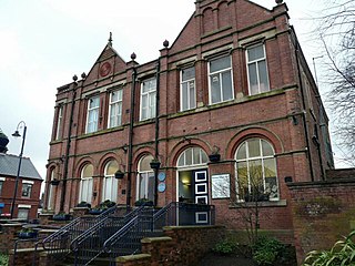
Ashton-in-Makerfield is a market town in the Metropolitan Borough of Wigan, Greater Manchester, England, 4 miles (6.4 km) south of Wigan. In 2011, it had a population of 28,762.

<span class="mw-page-title-main">Dukinfield</span> Town in Greater Manchester, England

Dukinfield is a town in Tameside, Greater Manchester, England, on the south bank of the River Tame opposite Ashton-under-Lyne, 6.3 miles (10.1 km) east of Manchester. At the 2011 Census, it had a population of 19,306.

<span class="mw-page-title-main">Haydock</span> Village in England

Haydock is a village within the Metropolitan Borough of St Helens, in Merseyside, England. At the 2011 Census, it had a population of 11,416 Haydock's historic area covers the Haydock electoral ward and a section of the Blackbrook ward.

<span class="mw-page-title-main">Coppull</span> Human settlement in England

Coppull is a village and civil parish in Lancashire, England. It is part of the Borough of Chorley, lies around 300 feet (91 m) above sea level. Its population is around 8,000, having been counted at 7,959 in the 2011 Census. It is bounded by Whittle Brook, Clancutt Brook, the River Yarrow, Eller Brook, Hic-Bibi Brook and Stars Brook. Coppull is located between Chorley and Standish, Greater Manchester, to the east of the A49 road near Charnock Richard.

Clayton is a suburb of Manchester, England, 3 miles east of the city centre on Ashton New Road.

The Ashton, Stalybridge and Liverpool Junction Railway was opened in 1846 to connect the industrial town of Ashton-under-Lyne to the developing railway network, and in particular to the port of Liverpool. It was a short line, joining the Manchester and Leeds Railway at Miles Platting and the connection to Liverpool was over that line and the Liverpool and Manchester Railway.

<span class="mw-page-title-main">Haigh, Greater Manchester</span> Village in Greater Manchester, England

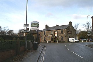
Haigh is a village and civil parish in the Metropolitan Borough of Wigan, Greater Manchester, England. Historically part of Lancashire, it is located next to the village of Aspull. The western boundary is the River Douglas, which separates the township from Wigan. To the north, a small brook running into the Douglas divides it from Blackrod. At the 2001 census it had a population of 594.

<span class="mw-page-title-main">Little Lever</span> Village in Greater Manchester, England

Little Lever is a village in the Metropolitan Borough of Bolton, Greater Manchester, England. Within the Historic County of Lancashire, it is 2 miles (3.2 km) southeast of Bolton, 2 miles (3.2 km) west of Radcliffe and 4 miles (6.4 km) southwest of Bury. In the 19th century, the population was employed in cotton mills, paper mills, bleach works, terracotta works, a rope works and numerous collieries.

<span class="mw-page-title-main">Hollinwood, Greater Manchester</span> Human settlement in England

Hollinwood is an area and electoral ward of the Metropolitan Borough of Oldham, Greater Manchester, England. The population at the 2011 census was 10,920.

<span class="mw-page-title-main">Bradford, Manchester</span> Human settlement in England

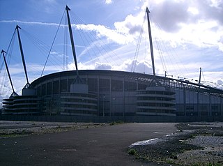
Bradford is a district of east Manchester, England, two miles north east of the city centre. The population at the 2011 census was 15,784. Historically in Lancashire, after the closure of its heavy industries Bradford was for many years an economically deprived area but has undergone regeneration with the building of the City of Manchester Stadium which hosted the 2002 Commonwealth Games and is now home to Manchester City F.C. Bradford is neighboured by Beswick to the south and the two areas are sometimes referred to as Bradford-with-Beswick. The River Medlock and the Ashton Canal run through Bradford.

<span class="mw-page-title-main">Blackrod</span> Human settlement in England

Blackrod is a town and civil parish in the Metropolitan Borough of Bolton, Greater Manchester,and also the Historic County of Lancashire, England, 3.9 miles (6.3 km) northeast of Wigan and 6.6 miles (10.6 km) west of Bolton. At the United Kingdom Census 2011, it had a population of 5,001.

<span class="mw-page-title-main">East Bowling</span> Area of Bradford in West Yorkshire, England

East Bowling is an area of Bradford, West Yorkshire, England located to the south of Bradford city centre. It forms the eastern half of the historic township and manor of Bowling. Bowling became a ward of the newly created Borough of Bradford in 1847. In 1882 the ward was split into the wards of East and West Bowling. In the north the boundary was along the Lancashire and Yorkshire Railway. To the south it was along Hall Lane and Bolling Hall Lane.

<span class="mw-page-title-main">Park Bridge</span> Human settlement in England

Park Bridge is an area of Ashton-under-Lyne, in the Metropolitan Borough of Tameside, in Greater Manchester, England. It is situated in the Medlock Valley, by Ashton-under-Lyne's border with Oldham. Park Bridge anciently lay within medieval manor of Ashton, however there is no record of Park Bridge until the 17th century. The name is probably a reference to the medieval Lyme Park, in the north west of the manor of Ashton. For nearly two hundred years from the 18th to the 20th centuries it was the site of the Park Bridge Ironworks.

<span class="mw-page-title-main">Manchester (ancient parish)</span>

Manchester was an ancient ecclesiastical parish of the hundred of Salford, in Lancashire, England. It encompassed several townships and chapelries, including the then township of Manchester. Other townships are now parts of the Anglican Diocese of Manchester and/or Greater Manchester.

<span class="mw-page-title-main">Beswick, Manchester</span> Human settlement in England

Beswick is an area of east Manchester, England. Historically in Lancashire, it neighbours the district of Openshaw to the east. The River Medlock and the Ashton Canal both run through it.

<span class="mw-page-title-main">Westleigh, Greater Manchester</span>

Westleigh, a suburb of Leigh, Greater Manchester, England, is one of three ancient townships, Westleigh, Bedford and Pennington, that merged in 1875 to form the borough of Leigh.

The Astley and Tyldesley Collieries Company formed in 1900 owned coal mines on the Lancashire Coalfield south of the railway in Astley and Tyldesley, then in the historic county of Lancashire, England. The company became part of Manchester Collieries in 1929 and some of its collieries were nationalised in 1947.

Tyldesley Coal Company was a coal mining company formed in 1870 in Tyldesley, on the Manchester Coalfield in the historic county of Lancashire, England that had its origins in Yew Tree Colliery, the location for a mining disaster that killed 25 men and boys in 1858.

<span class="mw-page-title-main">Bradford Colliery</span> Coal mine

Bradford Colliery was a coal mine in Bradford, Manchester, England. Although part of the Manchester Coalfield, the seams of the Bradford Coalfield correspond more closely to those of the Oldham Coalfield. The Bradford Coalfield is crossed by a number of fault lines, principally the Bradford Fault, which was reactivated by mining activity in the mid-1960s.

References

  1. Bradford, Lancashire; UK Genealogy Archives
53°29′N2°13′W / 53.48°N 2.21°W / 53.48; -2.21