Bradford, Manchester

Last updated

Bradford
City of Manchester Stadium.jpg
Greater Manchester UK location map 2.svg
Red pog.svg
Bradford
Location within Greater Manchester
Population15,784 (2011)
Ward Established2004
Ward Abolished2018
OS grid reference SJ8714298193
Metropolitan borough
Metropolitan county
Region
Country England
Sovereign state United Kingdom
Post town MANCHESTER
Postcode district M11
Dialling code 0161
Police Greater Manchester
Fire Greater Manchester
Ambulance North West
UK Parliament
List of places
UK
England
Greater Manchester
53°28′49″N2°11′43″W / 53.4803°N 2.1952°W / 53.4803; -2.1952

Bradford is a district of east Manchester, England, two miles north east of the city centre. The population at the 2011 census was 15,784. [1] Historically in Lancashire, after the closure of its heavy industries Bradford was for many years an economically deprived area but has undergone regeneration with the building of the City of Manchester Stadium which hosted the 2002 Commonwealth Games and is now home to Manchester City F.C. [2] Bradford is neighboured by Beswick to the south and the two areas are sometimes referred to as Bradford-with-Beswick. The River Medlock and the Ashton Canal run through Bradford.

Contents

History

The name of the area is ancient and in 1196 the village was recorded as Bradeford, [3] meaning the broad ford. Up to the Industrial Revolution, it was rural with woodland, pastures and brooks. Wolves and eagles once inhabited the woodlands and honey production was part of the local economy.

Coal mining

From Tudor times (1485–1603), sufficient coal was mined to supply most of the needs of Manchester and with the onset of the Industrial Revolution, Bradford Colliery provided fuel to power steam engines in the new cotton mills that were springing up in the district. With the coming of the Ashton Canal in 1797, the colliery was connected to it by means of a private branch.

In 1871, the owner of Bradford Colliery was R. T. Parker and the occupier, for rate purposes, was T. & C. Livesey. When deeper pit shafts were sunk, seams of fireclay were discovered and consequently a brickworks was built on the north side of the colliery site to manufacture firebricks for use in lining furnaces. In 1896, the pit manager was F. L. Ward and the under-manager was George Bentley. At that time there were 404 underground workers and 125 surface workers. Coal were mined for making gas, for household and manufacturing use and for raising steam. The brickworks was operational in 1896 owned by Edward Williams. It employed three underground workers extracting clay and two surface workers. In 1935 Bradford Colliery became part of Manchester Collieries and became part of the National Coal Board on nationalisation in 1947. It remained open until September 1968 when it closed, not because its supply of coal was exhausted, but because of the damage to property caused by subsidence that would have been caused in the exploitation of new coal seams under built-up areas.

Coal from the mine was fed to the nearby Stuart Street Power Station via an underground conveyor system.

Other industries

Gasholder in Bradford, Manchester Gasholder, Bradford, Manchester - geograph.org.uk - 6200.jpg
Gasholder in Bradford, Manchester

The other large employer in Bradford was Richard Johnson & Nephew (Bradford Ironworks), manufacturers of wire of all kinds. The ironworks was close to the Ashton Canal. In 1869, a gasometer was built at the new Bradford Gasworks and this, along with the adjacent colliery, ironworks and cotton mills, was a dominant feature of the landscape.

Governance

Bradford was originally a part of the Salford Hundred in the County Palatine of Lancashire. Bradford was an independent township of the ancient parish of Manchester, having its own parochial offices under the Manchester churchwardens. In 1841 this changed and the township became a member of the Manchester Poor Law Union, which was established under the Poor Law Amendment Act of 1841. From 13 April 1850 the village was a member of the Prestwich Union, constituted by order of the Poor Law Board in 1850. The Local Board was set up in 1863 under the Public Health Act of 1848. In 1896, Bradford was incorporated into the civil parish of North Manchester.

Under boundary changes by the Local Government Boundary Commission for England (LGBCE) the ward was abolished and replaced with the new electoral wards Ancoats and Beswick and Clayton and Openshaw in May 2018. [4]

ElectionCouncillorCouncillorCouncillor
2004 John Longsden (Lab)John Smith (Lab)Neil Swannick (Lab)
2006 John Longsden (Lab)John Smith (Lab)Neil Swannick (Lab)
2007 John Longsden (Lab)Rosa Battle (Lab)Neil Swannick (Lab)
2008 John Longsden (Lab)Rosa Battle (Lab)Neil Swannick (Lab)
2010 John Longsden (Lab)Rosa Battle (Lab)Neil Swannick (Lab)
2011 John Longsden (Lab)Rosa Battle (Lab)Neil Swannick (Lab)
2012 John Longsden (Lab)Rosa Battle (Lab)Neil Swannick (Lab)
2014 John Longsden (Lab)Rosa Battle (Lab)Neil Swannick (Lab)
2015 John Longsden (Lab)Rosa Battle (Lab)Neil Swannick (Lab)
2016 John Longsden (Lab)Rosa Battle (Lab)Emma Taylor (Lab)
2018 Ward abolishedWard abolishedWard abolished

  indicates seat up for re-election.   indicates ward abolished and replaced with new wards: Ancoats & Beswick and Clayton & Openshaw.

Geography

The Bradford township had an area of 288 acres between the River Medlock and Ashton Old Road. During the Industrial Revolution the area was covered with streets of terraced houses. The Ashton Canal crosses the township to the north and beyond the canal is Philips Park. the underlying rocks are the sandstones and shales of the Middle Coal Measures of the Manchester Coalfield. [3]

Regeneration

In addition to the City of Manchester Stadium and National Cycling Centre velodrome, Asda built its then largest store in the UK here, an Asda Supercentre, which opened in June 2002.

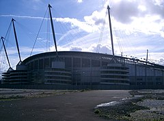
Bradford was home to the sculpture B of the Bang, built to commemorate the 2002 Commonwealth Games. At the time it was the tallest artwork in the UK, but after suffering structural problems was dismantled in 2009. [5]

Related Research Articles

<span class="mw-page-title-main">Ashton Canal</span> United Kingdom legislation

The Ashton Canal is a canal in Greater Manchester, England, linking Manchester with Ashton-under-Lyne.

Clayton is a suburb of Manchester, England, three miles east of the city centre on Ashton New Road.

The Ashton, Stalybridge and Liverpool Junction Railway was opened in 1846 to connect the industrial town of Ashton-under-Lyne to the developing railway network, and in particular to the port of Liverpool. It was a short line, joining the Manchester and Leeds Railway at Miles Platting and the connection to Liverpool was over that line and the Liverpool and Manchester Railway.

<span class="mw-page-title-main">Manchester Central (UK Parliament constituency)</span> Parliamentary constituency in the United Kingdom, 1974 onwards

Manchester Central is a parliamentary constituency in Greater Manchester created in 1974 represented in the House of Commons of the UK Parliament since 2012 by Lucy Powell of the Labour Party and Co-operative Party.

<span class="mw-page-title-main">Bradford-with-Beswick</span>

Beswick is an inner city area in Manchester, England. It consists of the ancient township off Beswick, Manchester, which is in small land and in the ancient parish of Manchester and hundred of Salford.

<span class="mw-page-title-main">Ancoats and Clayton</span> Human settlement in England

Ancoats and Clayton was an electoral district or ward in the north of the City of Manchester in North West England. The population of this ward at the 2011 census was 16,141. It includes the Ancoats and Clayton districts and part of the Northern Quarter. Under boundary changes by the Local Government Boundary Commission for England (LGBCE) the ward was abolished and replaced with the new electoral wards Ancoats and Beswick, Clayton and Openshaw, and Piccadilly from May 2018.

<span class="mw-page-title-main">East Bowling</span> Area of Bradford in West Yorkshire, England

East Bowling is an area of Bradford, West Yorkshire, England located to the south of Bradford city centre. It forms the eastern half of the historic township and manor of Bowling. Bowling became a ward of the newly created Borough of Bradford in 1847. In 1882 the ward was split into the wards of East and West Bowling. In the north the boundary was along the Lancashire and Yorkshire Railway. To the south it was along Hall Lane and Bolling Hall Lane.

Agecroft Colliery was a coal mine on the Manchester Coalfield that opened in 1844 in the Agecroft district of Pendlebury, Lancashire, England. It exploited the coal seams of the Middle Coal Measures of the Lancashire Coalfield. The colliery had two spells of use; the first between 1844 and 1932, when the most accessible coal seams were exploited, and a second lease of life after extensive development in the late 1950s to access the deepest seams.

<span class="mw-page-title-main">Park Bridge</span> Human settlement in England

Park Bridge is an area of Ashton-under-Lyne, in the Metropolitan Borough of Tameside, in Greater Manchester, England. It is situated in the Medlock Valley, by Ashton-under-Lyne's border with Oldham. Park Bridge anciently lay within medieval manor of Ashton, however there is no record of Park Bridge until the 17th century. The name is probably a reference to the medieval Lyme Park, in the north west of the manor of Ashton. For nearly two hundred years from the 18th to the 20th centuries it was the site of the Park Bridge Ironworks.

<span class="mw-page-title-main">Beswick, Manchester</span> Human settlement in England

Beswick is an area of east Manchester, England. Historically in Lancashire, it neighbours the district of Openshaw to the east. The River Medlock and the Ashton Canal both run through it.

<span class="mw-page-title-main">Brunswick Mill, Ancoats</span> Cotton mill in Manchester, England

Brunswick Mill, Ancoats is a former cotton spinning mill on Bradford Road in Ancoats, Manchester, England. The mill was built around 1840, part of a group of mills built along the Ashton Canal, and at that time it was one of the country's largest mills. It was built round a quadrangle, a seven-storey block facing the canal. It was taken over by the Lancashire Cotton Corporation in the 1930s and passed to Courtaulds in 1964. Production finished in 1967.

<span class="mw-page-title-main">Lancashire Coalfield</span> Coal mining region in England

The Lancashire Coalfield in North West England was an important British coalfield. Its coal seams were formed from the vegetation of tropical swampy forests in the Carboniferous period over 300 million years ago.

The Astley and Tyldesley Collieries Company formed in 1900 owned coal mines on the Lancashire Coalfield south of the railway in Astley and Tyldesley, then in the historic county of Lancashire, England. The company became part of Manchester Collieries in 1929 and some of its collieries were nationalised in 1947.

Tyldesley Coal Company was a coal mining company formed in 1870 in Tyldesley, on the Manchester Coalfield in the historic county of Lancashire, England that had its origins in Yew Tree Colliery, the location for a mining disaster that killed 25 men and boys in 1858.

Bedford Colliery, also known as Wood End Pit, was a coal mine on the Manchester Coalfield in Bedford, Leigh, Lancashire, England. The colliery was owned by John Speakman, who started sinking two shafts on land at Wood End Farm in the northeast part of Bedford, south of the London and North Western Railway's Tyldesley Loopline in about 1874. Speakman's father owned Priestners, Bankfield, and Broadoak collieries in Westleigh. Bedford Colliery remained in the possession of the Speakman family until it was amalgamated with Manchester Collieries in 1929.

<span class="mw-page-title-main">Manchester Coalfield</span> Coal mining region in north-west England

The Manchester Coalfield is part of the South Lancashire Coalfield, the coal seams of which were laid down in the Carboniferous Period. Some easily accessible seams were worked on a small scale from the Middle Ages, and extensively from the beginning of the Industrial Revolution in the early 19th century until the last quarter of the 20th century. The Coal Measures lie above a bed of Millstone Grit and are interspersed with sandstones, mudstones, shales, and fireclays. The Lower Coal Measures occupy the high ground of the West Pennine Moors above Bolton and are not worked in the Manchester Coalfield. The most productive of the coal measures are the lower two thirds of the Middle Coal Measures where coal is mined from seams between the Worsley Four Foot and Arley mines. The deepest and most productive collieries were to the south of the coalfield. The coalfield is affected by the northwest to southeast aligned Pendleton Fault along the Irwell Valley and the Rossendale Valley anticline. The Coal Measures generally dip towards the south and west. Numerous other smaller faults affect the coalfield. The Upper Coal Measures are not worked in the Manchester Coalfield.

Bridgewater Collieries originated from the coal mines on the Manchester Coalfield in Worsley in the historic county of Lancashire owned by Francis Egerton, 3rd Duke of Bridgewater in the second half of the 18th century. After the Duke's death in 1803 his estate was managed by the Bridgewater Trustees until the 3rd Earl of Ellesmere inherited the estates in 1903. Bridgewater Collieries was formed in 1921 by the 4th Earl. The company merged with other prominent mining companies to form Manchester Collieries in 1929.

<span class="mw-page-title-main">Bradford Colliery</span> Coal mine

Bradford Colliery was a coal mine in Bradford, Manchester, England. Although part of the Manchester Coalfield, the seams of the Bradford Coalfield correspond more closely to those of the Oldham Coalfield. The Bradford Coalfield is crossed by a number of fault lines, principally the Bradford Fault, which was reactivated by mining activity in the mid-1960s.

<span class="mw-page-title-main">Ancoats and Beswick</span> Electoral ward in England

Ancoats and Beswick is an electoral ward of Manchester, England created by the Local Government Boundary Commission for England (LGBCE) replacing the previous electoral wards of Ancoats & Clayton and Bradford for the local elections 2018.

<span class="mw-page-title-main">Clayton and Openshaw (ward)</span> Electoral ward in England

Clayton and Openshaw is an area and electoral ward of Manchester, England created by the Local Government Boundary Commission for England (LGBCE) replacing the previous electoral wards of Ancoats & Clayton and Bradford for the local elections 2018.

References

  1. "City of Manchester ward population 2011" . Retrieved 4 January 2016.
  2. Bradford profile Archived October 25, 2007, at the Wayback Machine - e-manchester.gov.uk
  3. 1 2 Farrer, William; Brownbill, J, eds. (1911), "Bradford", A History of the County of Lancaster: Volume 4, British History Online, pp. 274–275, retrieved 10 December 2010
  4. LGBCE (April 2017). Final recommendations on the new electoral arrangements for Manchester City Council (PDF). Local Government Boundary Commission for England. Archived from the original (PDF) on 4 February 2018.
  5. Jenkins, Russell (4 August 2009). "It began with a Bang but landmark sculpture is sent for recycling". The Times. London. Retrieved 4 December 2010.

Further reading