Related Research Articles

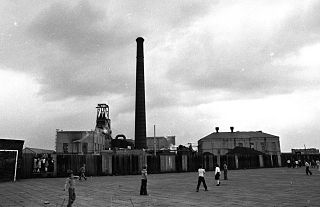
The Astley Green Colliery Museum is a museum run by the Red Rose Steam Society in Astley near Tyldesley in Greater Manchester, England. Before becoming a museum, the site was a working colliery that produced coal from 1912 to 1970; it is now protected as a Scheduled Monument. The museum occupies a 15-acre (6 ha) site by the Bridgewater Canal which has the only surviving pit headgear and engine house on the Lancashire Coalfield.

Beswick is an inner city area in Manchester, England. It consists of the ancient township off Beswick, Manchester, which is in small land and in the ancient parish of Manchester and hundred of Salford.
Agecroft Colliery was a coal mine on the Manchester Coalfield that opened in 1844 in the Agecroft district of Pendlebury, Lancashire, England. It exploited the coal seams of the Middle Coal Measures of the Lancashire Coalfield. The colliery had two spells of use; the first between 1844 and 1932, when the most accessible coal seams were exploited, and a second lease of life after extensive development in the late 1950s to access the deepest seams.

Penwyllt is a hamlet located in the upper Swansea Valley in Powys, Wales, lying within the Brecon Beacons National Park.
The Elsecar Collieries were the coal mines sunk in and around Elsecar, a small village to the south of Barnsley in what is now South Yorkshire, but was traditionally in the West Riding of Yorkshire.

The Lancashire Coalfield in North West England was an important British coalfield. Its coal seams were formed from the vegetation of tropical swampy forests in the Carboniferous period over 300 million years ago.

The Manchester Coalfield is part of the South Lancashire Coalfield, the coal seams of which were laid down in the Carboniferous Period. Some easily accessible seams were worked on a small scale from the Middle Ages, and extensively from the beginning of the Industrial Revolution in the early 19th century until the last quarter of the 20th century. The Coal Measures lie above a bed of Millstone Grit and are interspersed with sandstones, mudstones, shales, and fireclays. The Lower Coal Measures occupy the high ground of the West Pennine Moors above Bolton and are not worked in the Manchester Coalfield. The most productive of the coal measures are the lower two thirds of the Middle Coal Measures where coal is mined from seams between the Worsley Four Foot and Arley mines. The deepest and most productive collieries were to the south of the coalfield. The coalfield is affected by the northwest to southeast aligned Pendleton Fault along the Irwell Valley and the Rossendale Valley anticline. The Coal Measures generally dip towards the south and west. Numerous other smaller faults affect the coalfield. The Upper Coal Measures are not worked in the Manchester Coalfield.

Astley Green Colliery was a coal mine in Astley, Greater Manchester, then in the historic county of Lancashire, England. It was the last colliery to be sunk in Astley. Sinking commenced in 1908 by the Pilkington Colliery Company, a subsidiary of the Clifton and Kersley Coal Company, at the southern edge of the Manchester Coalfield, working the Middle Coal Measures where they dipped under the Permian age rocks under Chat Moss. The colliery was north of the Bridgewater Canal. In 1929 it became part of Manchester Collieries, and in 1947 was nationalised and integrated into the National Coal Board. It closed in 1970, and is now Astley Green Colliery Museum.
Parsonage Colliery was a coal mine operating on the Lancashire Coalfield in Leigh, then in the historic county of Lancashire, England. The colliery, close to the centre of Leigh and the Bolton and Leigh Railway was sunk between 1913 and 1920 by the Wigan Coal and Iron Company and the first coal was wound to the surface in 1921. For many years its shafts to the Arley mine were the deepest in the country. The pit was close to the town centre and large pillars of coal were left under the parish church and the town's large cotton mills.
Gin Pit was a coal mine operating on the Lancashire Coalfield from the 1840s in Tyldesley, Greater Manchester then in the historic county of Lancashire, England. It exploited the Middle Coal Measures of the Manchester Coalfield and was situated to the south of the Tyldesley Loopline.
Cleworth Hall Colliery was a coal mine operating on the Manchester Coalfield after 1874 in Tyldesley, Greater Manchester, then in the historic county of Lancashire, England.

Bradford Colliery was a coal mine in Bradford, Manchester, England. Although part of the Manchester Coalfield, the seams of the Bradford Coalfield correspond more closely to those of the Oldham Coalfield. The Bradford Coalfield is crossed by a number of fault lines, principally the Bradford Fault, which was reactivated by mining activity in the mid-1960s.
The Tarenni Colliery and its associated workings, are a series of coal mines and pits located between the villages of Godre'r Graig and Cilybebyll located in the valley of the River Tawe, in Neath Port Talbot county borough, South Wales.

Fairbottom Bobs is a Newcomen-type beam engine that was used in the 18th century as a pumping engine to drain a colliery near Ashton-under-Lyne. It is probably the world's second-oldest surviving steam engine. The engine was installed at Cannel Colliery at Fairbottom near Ashton-under-Lyne around 1760 or 1764. It became known locally as Fairbottom Bobs.

The Chandos Glass Cone in Bridgwater, in the English county of Somerset, was built in 1725 as a kiln for a glassworks. The remains have been scheduled as an ancient monument.

The Burnley Coalfield is the most northerly portion of the Lancashire Coalfield. Surrounding Burnley, Nelson, Blackburn and Accrington, it is separated from the larger southern part by an area of Millstone Grit that forms the Rossendale anticline. Occupying a syncline, it stretches from Blackburn past Colne to the Yorkshire border where its eastern flank is the Pennine anticline.
Hapton Valley Colliery was a coal mine on the edge of Hapton near Burnley in Lancashire, England. Its first shafts were sunk in the early 1850s and it had a life of almost 130 years, surviving to be the last deep mine operating on the Burnley Coalfield.
Towneley Colliery or Towneley Desmesne was a coal mine on the Burnley Coalfield in Burnley, Lancashire, England. Sunk in the late 1860s, it was linked to the Lancashire and Yorkshire Railway's Burnley to Todmorden line which became known as the Copy Pit route and, by tramway, to the Leeds and Liverpool Canal.

The Lithgow Valley Colliery and Pottery Site is a heritage-listed former pottery and colliery and now pottery and visitor attraction at Bent Street, Lithgow, City of Lithgow, New South Wales, Australia. It was built from 1876 to 1945. It is also known as Lithgow Pottery and Brickworks. The property is privately owned. It was added to the New South Wales State Heritage Register on 2 April 1999.
References
Citations
- ↑ "North Western Division Map 87 A&B", The Coalmining History Research Centre, archived from the original on 3 October 2011, retrieved 21 August 2011
- 1 2 Redhead et al. (2011), pp. 22–23
Bibliography
- Redhead, Norman; Miller, Ian; Rowland, Marie; Parsons, Adam (2011), Rediscovering Bradford: Archaeology in the Engine Room of Manchester, Greater Manchester's Past Revealed, Oxford Archaeology, ISBN 978-1-907686-04-7