Bridgeport, New Jersey

Last updated

Bridgeport, New Jersey
Bridgeport, NJ, Main St., April 2021.jpg
Bridgeport as shown along Main Street in April 2021
Location map of Gloucester County, New Jersey.svg
Red pog.svg
Bridgeport
USA New Jersey location map.svg
Red pog.svg
Bridgeport
Usa edcp location map.svg
Red pog.svg
Bridgeport
Coordinates: 39°48′03″N75°20′51″W / 39.80083°N 75.34750°W / 39.80083; -75.34750 Coordinates: 39°48′03″N75°20′51″W / 39.80083°N 75.34750°W / 39.80083; -75.34750
Country Flag of the United States.svg  United States
State Flag of New Jersey.svg  New Jersey
County Gloucester
Township Logan
Area
[1]
  Total0.20 sq mi (0.52 km2)
  Land0.20 sq mi (0.52 km2)
  Water0.00 sq mi (0.00 km2)
Elevation
26 ft (8 m)
Population
 (2020) [2]
  Total389
  Density1,954.77/sq mi (753.67/km2)
Time zone UTC-5 (Eastern (EST))
  Summer (DST) UTC-4 (EDT)
ZIP Code
08014 [3]
Area code 856
GNIS feature ID874928 [4]

Bridgeport is a census-designated place{ [5] (CDP) and unincorporated community that is part of Logan Township, in Gloucester County, in the U.S. state of New Jersey. [6] At the 2020 United States census, the population of the CDP was 389. [2] in the 2010 census, the population was 504. [7]

Contents

The area is served as United States Postal Service ZIP Code 08014. [3]

History

Bridgeport, along with Swedesboro (Sveaborg) and Finns Point (Varkens Kill), was one of only three settlements established in New Jersey as a part of the New Sweden colony, the fort at Nya Elfsborg having been abandoned. The settlement was founded around 1650, and originally called Nya Stockholm, "New Stockholm", but the name was changed at a later date. [8]

After the 2001 anthrax attacks, a facility was set up in Bridgeport for the use of a continuous wave accelerator called a Rhodotron, from the Belgian company IBA, to irradiate federal mail. [9]

Geography

Bridgeport lies along the Delaware River at the mouth of the Raccoon Creek. U.S. Route 322 (US 322) enters New Jersey in Bridgeport via the Commodore Barry Bridge, and continues on to cross US 130 and Interstate 295 before leaving Logan Township. Route 44 is an old alignment of US 130, beginning at a point north of US 322. Route 324 is an east-west state highway completely within Bridgeport, running from where a ferry used to take US 322 across the river to a dead end next to the current US 322. Bridgeport Speedway is located in the community. There is a private marina and a small airfield in town, and a Penns Grove Secondary line crosses Raccoon Creek at the Conrail Railroad Bridge in Bridgeport at mile 2.0.

Demographics

Historical population
CensusPop.
2020 389
U.S. Decennial Census [10] [2]

Related Research Articles

<span class="mw-page-title-main">Brickerville, Pennsylvania</span> Census-designated place in Pennsylvania, United States

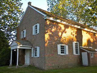
Brickerville is an unincorporated community and census-designated place (CDP) in Elizabeth Township, Lancaster County, Pennsylvania, United States, with a ZIP code of 17543. The population was 1,309 at the 2010 census.

<span class="mw-page-title-main">Logan Township, New Jersey</span> Township in Gloucester County, New Jersey, United States

Logan Township is a township in Gloucester County in the U.S. state of New Jersey. As of the 2010 U.S. census, the township's population was 6,042, reflecting an increase of 10 (+0.2%) from the 6,032 counted in the 2000 census.

<span class="mw-page-title-main">Mullica Hill, New Jersey</span> Place in Gloucester County, New Jersey, United States

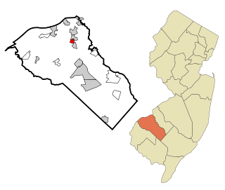
Mullica Hill is a census-designated place (CDP) and unincorporated community in Harrison Township in Gloucester County, New Jersey. As of the 2010 United States census, the CDP's population was 3,982.

<span class="mw-page-title-main">Oak Valley, New Jersey</span> Census-designated place in New Jersey, United States

Oak Valley is an unincorporated community and census-designated place (CDP) located within Deptford Township in Gloucester County, New Jersey. As of the 2010 U.S. census, Oak Valley's population was 3,483.

<span class="mw-page-title-main">Swedesboro, New Jersey</span> Borough in Gloucester County, New Jersey, United States

Swedesboro is a borough in Gloucester County in the U.S. state of New Jersey. As of the 2010 U.S. census, the borough's population was 2,584, reflecting an increase of 529 (+25.7%) from the 2,055 counted in the 2000 census.

<span class="mw-page-title-main">Turnersville, New Jersey</span> Census-designated place in New Jersey, United States

Turnersville is an unincorporated community and census-designated place (CDP) located within Washington Township, in Gloucester County, New Jersey, United States. As of the 2010 United States Census, the CDP's population was 3,742.

<span class="mw-page-title-main">Williamstown, New Jersey</span> Census-designated place in New Jersey, United States

Williamstown is an unincorporated community and census-designated place (CDP) located in Monroe Township in Gloucester County, New Jersey. As of the 2010 U.S. census, Williamstown's population was 15,567.

<span class="mw-page-title-main">Dayton, New Jersey</span> Populated place in Middlesex County, New Jersey, US

Dayton is an unincorporated community and census-designated place (CDP) located within South Brunswick, in Middlesex County, New Jersey, United States. At the 2010 United States Census, the CDP's population was 7,063.

Deerfield is an unincorporated community and census-designated place within Upper Deerfield Township, Cumberland County, New Jersey, United States. It was first listed as a CDP in the 2020 census with a population of 230.

<span class="mw-page-title-main">Dorneyville, Pennsylvania</span> Census-designated place in Pennsylvania, United States

Dorneyville is a census-designated place in Lehigh County, Pennsylvania. As of the 2020 census the population was 4,850. Dorneyville is located just west of Allentown in South Whitehall Township and Salisbury Township.

<span class="mw-page-title-main">Delmont, New Jersey</span> Census-designated place in New Jersey

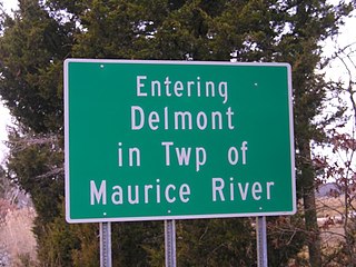
Delmont is an unincorporated community and census-designated place located within Maurice River Township, in Cumberland County, New Jersey, United States. The area is served as United States Postal Service ZIP code 08314. It was first listed as a CDP in the 2020 census with a population of 122.

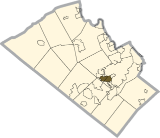
Hopeland is a small unincorporated hamlet and census-designated place (CDP) in Lancaster County in the south of the U.S. state of Pennsylvania. The hamlet's ZIP code is 17533. As of the 2010 census the population was 738.

<span class="mw-page-title-main">Robbinsville (CDP), New Jersey</span> Census-designated place in New Jersey, United States

Robbinsville is a census-designated place (CDP) located within Robbinsville Township in Mercer County, New Jersey, United States. The area is served as United States Postal Service ZIP Code 08691. As of the 2010 United States Census, the population for the CDP was 3,041.

<span class="mw-page-title-main">Mercerville, New Jersey</span> Census-designated place in New Jersey, United States

Mercerville is an unincorporated community and census-designated place (CDP) located within Hamilton Township, in Mercer County, New Jersey, United States. As of the 2010 United States Census, the CDP's population was 13,230. Until after the 2000 Census, the area was part of the Mercerville-Hamilton Square CDP. For the 2010 Census it was split into two CDPs, Mercerville and Hamilton Square.

<span class="mw-page-title-main">Stewartsville, New Jersey</span> Populated place in Warren County, New Jersey, US

Stewartsville is an unincorporated community and census-designated place (CDP) located within Greenwich Township in Warren County, New Jersey, United States, that was created as part of the 2010 United States Census. As of the 2010 Census, the CDP's population was 349.

<span class="mw-page-title-main">Hancock's Bridge, New Jersey</span> Census-designated place in New Jersey, United States

Hancock's Bridge is an unincorporated community and census-designated place (CDP) located within Lower Alloways Creek Township, in Salem County, New Jersey, United States. As of the 2010 United States Census, the CDP's population was 254. The area is served as United States Postal Service ZIP code 08038.

Richwood is an unincorporated community and census-designated place (CDP) located in Gloucester County, New Jersey, United States, that is split between Harrison Township and Mantua Township. As of the 2010 United States Census, the CDP's total population was 3,459.

<span class="mw-page-title-main">Ellisburg, New Jersey</span> Census-designated place in New Jersey, United States

Ellisburg is an unincorporated community and census-designated place (CDP) located within Cherry Hill Township, in Camden County, New Jersey, United States. As of the 2010 United States Census, the CDP's population was 8,168. The area had been part of the combined Erlton-Ellisburg CDP, which was discontinued after the 2000 Census.

<span class="mw-page-title-main">Florence (CDP), New Jersey</span> Populated place in Burlington County, New Jersey, US

Florence is an unincorporated community and census-designated place (CDP) located within Florence Township, in Burlington County, New Jersey, United States, that was established as part of the 2010 United States Census. As of the 2000 United States Census, the CDP was combined as Florence-Roebling, which had a total population of 8,200. As of the 2010 Census, the Florence-Roebling CDP was split into its components, Roebling and Florence. As of the 2010 Census, the population of the Florence CDP was 4,426.

<span class="mw-page-title-main">Quinton (CDP), New Jersey</span> Census-designated place in New Jersey, United States

Quinton is an unincorporated community and census-designated place (CDP) located within Quinton Township, in Salem County, New Jersey, United States. As of the 2010 United States Census, the CDP's population was 1,402.

References

  1. "ArcGIS REST Services Directory". United States Census Bureau. Retrieved October 11, 2022.
  2. 1 2 3 "Census Population API". United States Census Bureau. Retrieved October 11, 2022.
  3. 1 2 Zip Codes, State of New Jersey. Accessed March 16, 2015.
  4. "Bridgeport". Geographic Names Information System . United States Geological Survey, United States Department of the Interior.
  5. State of New Jersey Census Designated Places - BVP20 - Data as of January 1, 2020, United States Census Bureau. Accessed December 30, 2022.
  6. Locality Search, State of New Jersey. Accessed June 9, 2016.
  7. DP-1 Profile of General Population and Housing Characteristics: 2010 from the 2010 Demographic Profile Data for ZCTA5 08014 Archived 2020-02-13 at archive.today , United States Census Bureau. Accessed March 16, 2015.
  8. The Swedes and Finns in New Jersey (Federal Writers' Project of WPA. Bayonne, New Jersey: Jersey Printing Company, Inc. 1938)
    - "New Sweden". familysearch.org.
  9. "Postmaster Asks Senate for Bailout of $5 Billion" [ dead link ], The Washington Post , November 9, 2001
  10. "Census of Population and Housing". Census.gov. Retrieved June 4, 2016.

Commons-logo.svg Media related to Bridgeport, New Jersey at Wikimedia Commons