Bridger Antelope Trap | |
| Location | Uinta County, Wyoming, USA |
|---|---|
| Nearest city | Evanston, Wyoming |
| NRHP reference No. | 71000893 [1] |
| Added to NRHP | 21 January 1971 |
The Bridger Antelope Trap is an archaeological site in Uinta County, Wyoming, associated with local Indigenous hunting practices. As an important example of hunting and gathering strategies, the site provides important clues to native subsistance in the past. The Wyoming State Historic Preservation Office nominated the antelope trap for the National Register of Historic Places (NRHP). The NRHP added the site to the Register on 21 January 1971. [2]
Archaeological investigations, conducted in the late 1960s by Dr. George Frison of the University of Wyoming, indicated that hunters likely used the trap before 1850. However, its length of service is unknown; archaeologists believe that the site is associated with Indians of the Late Prehistoric Period. The Natives' technique, when hunting antelope, was to drive a herd into the long entrance of traps similar to the Bridger Antelope Trap. The opening, made of juniper wood, led to the trap proper, located at the base of a hill. This portion of the structure was circular and also constructed of juniper wood; hunters drove the antelope around the path until exhausted, at which time they would dispatch the exhausted prey.
The Bridger Antelope Trap covers close to 26 acres (110,000 m2). Its entrance is arc-shaped and is close to 0.25 miles (400 m) in length, extending in a northeast-to-southwest direction across a smooth valley. The trap itself serves as an extension of the entrance and has a diameter of around 700 feet (210 m).
The National Register of Historic Places (NRHP) is the United States federal government's official list of districts, sites, buildings, structures, and objects deemed worthy of preservation for their historical significance or "great artistic value". A property listed in the National Register, or located within a National Register Historic District, may qualify for tax incentives derived from the total value of expenses incurred in preserving the property.

Petit Jean State Park is a 3,471-acre (1,405 ha) park in Conway County, Arkansas managed by the Arkansas Department of Parks and Tourism. It is located atop Petit Jean Mountain adjacent to the Arkansas River in the area between the Ouachita Mountains and Ozark Plateaus.

The U.S. National Register of Historic Places (NRHP) classifies its listings by various types of properties. Listed properties generally fall into one of five categories, though there are special considerations for other types of properties which do not fit into these five broad categories or fit into more specialized subcategories. The five general categories for NRHP properties are: building, district, object, site, and structure.
The Squirrel Meadow Guard Station is a ranger station in the backcountry of Targhee National Forest in Wyoming. The original facility was established in 1907, with the present structures built in 1934. The log cabin station is an example of a standard US Forest Service backcountry patrol structure.
The UXU Ranch is a historic dude ranch in Shoshone National Forest near Wapiti, Wyoming. The ranch began as a sawmill, as early as 1898. In 1929 Bronson Case "Bob" Rumsey obtained a permit from the U.S. Forest Service to operate a dude ranch on the property, using the sawmill headquarters building, a lodge, and tent cabins. Most of the current structures were built in the 1920s and 1930s from lumber milled on the site.
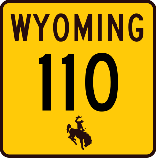
The Entrance Road at Devils Tower National Monument, officially known as Wyoming Highway 110, is a .585-mile-long (0.941 km) scenic road that provides the approach to the Devil's Tower eminence, affording planned views to arriving visitors.

This is a list of the National Register of Historic Places listings in Big Horn County, Wyoming.

This is a list of the National Register of Historic Places listings in Converse County, Wyoming.

The 650-foot (200 m) Dale Creek Crossing, completed in 1868 in the southeastern Wyoming Territory, presented engineers of the United States' first transcontinental railroad one of their most difficult challenges. Dale Creek Bridge, the longest bridge on the Union Pacific Railroad (UP), reached 150 feet (46 m) above Dale Creek, two miles (3.2 km) west of Sherman, Wyoming. The first Dale Creek Bridge was a wooden structure 720 feet in length. The eastern approach to the bridge site, near the highest elevation on the UP, 8,247 feet (2,514 m) above sea level, required cutting through granite for nearly a mile. Solid rock also confronted workers on the west side of the bridge where they made a cut one mile (1.6 km) in length.
The Wardell Buffalo Trap in Sublette County, Wyoming is a small box canyon used by Native Americans for 500 years during the Late Prehistoric Period. Nearly 55 feet (17 m) of bison bones were found at the site. A campsite and butchering area is located nearby, and evidence has been found for a fence at the entrance to the canyon.

The LoDaisKa site is a prominent archaeological site in the U.S. state of Colorado, located within a rockshelter near Morrison. The rockshelter was first inhabited by people of the Archaic through the Middle Ceramic period, generally spanning 3000 BC to 1000 AD.

Roxborough State Park Archaeological District is located in Douglas County, Colorado. Roxborough State Park, 25 miles (40 km) south of Denver, Colorado, is a Colorado State Park day park. Archaeological artifacts reflect that there were prehistoric hunter-gatherers who lived or camped, made tools from stone quarries, and farmed in the Roxborough State Park area.
The Trinchera Cave Archeological District (5LA9555) is an archaeological site in Las Animas County, Colorado with artifacts primarily dating from 1000 BC to AD 1749, although there were some Archaic period artifacts found. The site was added to the National Register of Historic Places in 2001 and is located on State Trust Lands.

The DML Butler Bridge is a historic bridge over the North Platte River in Carbon County, Wyoming, United States, that is listed on the National Register of Historic Places (NRHP).

The Trappers Point Site is an archaeological site located near Pinedale, Wyoming. The site, which dates to the Early Archaic period, is the oldest known location used for the mass killing of pronghorn antelope. In addition, a large number of projectile points have been found at the site; the variety of projectile point designs at the site have helped establish how these tools developed, and the presence of points from many parts of the Green River valley have aided in determining prehistoric migration patterns. The site has been called "a major discovery in Wyoming archaeology" and "one of the key sites in Wyoming".

Granger Station State Historic Site, also known as Granger Stage Station, South Bend Station and Ham's Fork Station, is a state park in Granger, Wyoming, United States, that is listed on the National Register of Historic Places (NRHP).

The Jim Baker Cabin was built in 1873 by frontiersman Jim Baker as a fortified house on the Little Snake River at Savery Creek near present-day Savery, Wyoming. The two-story log building measures 31 feet (9.4 m) by 16 feet (4.9 m) with two rooms on the lower level and a single smaller room on the upper level. The outer walls are made of logs 12 inches (30 cm) to 15 inches (38 cm) thick.

Medicine Lodge State Archeological Site is a Wyoming state park that interprets the Medicine Lodge Creek Site, a prehistoric Native American archeological site near Hyattville, Wyoming. It is administered by the Wyoming Division of State Parks and Historic Sites. The site is at the base of a steep limestone outcropping near the point where the dry and running portions of Medicine Lodge Creek join. for a protected location with ready access to water. The site includes petroglyphs and pictographs on the rock face. Excavations starting in the 1970s have found twelve levels of habitation in 10.5 feet of stratum, ranging from historic times to 8300 years before the present. The site comprises a portion of the former Wickwire Ranch, which was purchased by the state in 1972 and became to Medicine Lodge Wildlife Habitat Management Area of 12,000 acres (4,900 ha). The archeological site was designated in 1973. The site is managed as a state park, with campgrounds and a visitor center. It was added to the National Register of Historic Places on July 5, 1973.
The Darwin Ranch in Teton County, Wyoming near Cora, Wyoming is a guest ranch which was listed on the National Register of Historic Places in 2021.
Applicable Criteria: INFORMATION POTENTIAL
The site provides evidence of a unique example of food procurement on the Northwestern Plains.