Major bridges
| # | Name | Usage | Description | Suburbs | Photo |
|---|---|---|---|---|---|
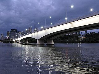
| 1 | Sir Leo Hielscher (two bridges) — original bridge formerly known as the Gateway Bridge | vehicles, cyclists & pedestrians | Original bridge opened January 1986 by the Duke of Edinburgh Duplicate bridge opened May 2010. Concrete box girder design. 260 metre (853 ft) main span. [3] | Eagle Farm (north) to Murarrie (south) |  |
| 2 | Story | vehicles & pedestrians | Opened July 1940. Steel truss design. 777 metres (2,549 ft) long with a 282-metre (925 ft) main span. [4] | Fortitude Valley (north) to Kangaroo Point (south) | 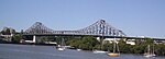 |
| 3 | Captain Cook | vehicles | Opened 1972. Concrete box girder design. 555 metres (1,821 ft) long with 183 metre (600 ft) main span. [5] | Brisbane City (north) to Kangaroo Point (south) |  |
| 4 | Goodwill | pedestrians & cyclists | Opened October 2001. 450 metres (1,476 ft) long with 102 metre (335 ft) main span. [6] | Brisbane City (north) to South Brisbane (south) |  |
| 5 | Victoria | buses, cyclists & pedestrians | Opened 1969. Replaced its namesake. 146.3 metre (480 ft) main span. [7] | Brisbane City (north) to South Brisbane (south) |  |
| 6 | Kurilpa | pedestrians & cyclists | Opened October 2009. 'Tensegrity' design. 425m long pathway [8] | Brisbane City (north) to South Brisbane (south) |  |
| 7 | William Jolly — also known as Grey Street Bridge | vehicles & pedestrians | Opened March 1932. Concrete arch design. 498 metres (1,634 ft) long with a 73-metre (240 ft) main span. [9] | Brisbane City (north) to South Brisbane (south) |  |
| 8 | Merivale | rail | Opened November 1978. Tied steel arch design. Main span 132 metre (433 ft). [10] | Brisbane City (north) to South Brisbane (south) |  |
| 9 | Go Between — formerly known as Hale Street Link | vehicles, cyclists & pedestrians | Opened 5 July 2010. Concrete box girder balanced cantilever design. [11] | Brisbane City (north) to South Brisbane (south) |  |
| 10 | Eleanor Schonell — formerly known as Green Bridge | buses, cyclists & pedestrians | Opened December 2006. Cable-stayed design. 390 metres (1,280 ft) long. [12] | St Lucia (north) to Dutton Park (south) |  |
| 11 | Jack Pesch | cyclists & pedestrians | Opened October 1998. Steel cable-stay design. [13] | Indooroopilly (north) to Chelmer (south) |  |
| 12 | Albert | rail | Opened 1895. Steel truss design. Replaced its namesake. 208 metres (682 ft) long with two spans each 103.7 metres (340 ft). [14] | Indooroopilly (north) to Chelmer (south) |  |
| 13 | Indooroopilly Railway | rail | Opened 1957. Steel truss design. 208.5 metres (684 ft) long with two equal spans. [15] | Indooroopilly (north) to Chelmer (south) | 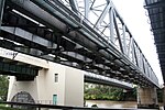 |
| 14 | Walter Taylor | vehicles & pedestrians | Opened February 1936. Suspension design. Main span 183 metres (600 ft). The bridge's towers are occupied. [16] | Indooroopilly (north) to Chelmer (south) |  |
| 15 | Centenary | vehicles, cyclists & pedestrians | Original bridge opened in 1964. Duplicate bridge opened in 1986. Concrete girder [17] | Kenmore, Fig Tree Pocket (north) to Jindalee (south) |  |