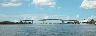
The Sir Leo Hielscher Bridges, formerly and still collectively referred to as the Gateway Bridge, are a pair of twin road bridges that carry the Gateway Motorway (M1) over the Brisbane River, skirting the eastern suburbs of the city of the same name. The western bridge carries traffic to the north and the eastern bridge carries traffic to the south. They are the most eastern crossings of the Brisbane River and the closest to Moreton Bay, crossing at the Quarries Reach and linking the suburbs of Eagle Farm and Murarrie. The original western bridge was opened on 11 January 1986 and cost A$92 million to build. The duplicate bridge was opened in May 2010, and cost $350 million.

The Story Bridge is a heritage-listed steel cantilever bridge spanning the Brisbane River that carries vehicular, bicycle and pedestrian traffic between the northern and the southern suburbs of Brisbane, Queensland, Australia. It is the longest cantilever bridge in Australia.
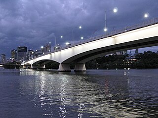
The Captain Cook Bridge is a road bridge that carries the Pacific Motorway across the Brisbane River in Brisbane, in the state of Queensland, Australia. It was built exclusively for vehicular traffic and was completed in late 1972. The bridge had its naming ceremony on 13 December 1972, with it opening in January/February 1973. A once only pedestrian walk event across the bridge happened shortly before it was opened to vehicular traffic on 21 January 1973, organised by the Rotary Club of Stones Corner. The bridge crosses at the South Brisbane Reach of the river, linking Gardens Point in the Brisbane central business district on the north side to Kangaroo Point and South Brisbane on the southside.

The Victoria Bridge is a bus and pedestrian bridge over the Brisbane River. The current bridge, opened in 1969, is the third permanent crossing erected at this location. Since 24 January 2021, the bridge has been closed to general traffic, and now carries buses, pedestrians and cyclists only.

The William Jolly Bridge is a heritage-listed road bridge over the Brisbane River between North Quay in the Brisbane central business district and Grey Street in South Brisbane, within City of Brisbane, Queensland, Australia. It was designed by Harding Frew and built from 1928 to 1932 by MR Hornibrook.
Hornibrook Bridge is a heritage-listed mostly-demolished road bridge on the Hornibrook Highway over Hays Inlet at Bramble Bay from Brighton, City of Brisbane to Clontarf, City of Moreton Bay, Queensland, Australia. It was designed by Manuel Hornibrook and built from 1932 to 1935 by Manuel Hornibrook. It was added to the Queensland Heritage Register on 7 October 1994.

Reading Bridge is a road bridge over the River Thames at Reading in the English county of Berkshire. The bridge links the centre of Reading on the south bank with the Lower Caversham area of the cross-river suburb, and former village, of Caversham on the north bank. It crosses the river a short way above Caversham Lock.

The South Bank Parklands are located at South Bank within the suburb of South Brisbane in Brisbane, Queensland, Australia. The parkland, on the transformed site of Brisbane's World Expo 88, was officially opened to the public on 20 June 1992.

The Eleanor Schonell Bridge, better known as the Green Bridge, is a 390-metre (1,280 ft)-long cable-stayed bridge which crosses the Brisbane River between Dutton Park and the University of Queensland's St Lucia campus, connecting the UQ Lakes and Dutton Park Place busway stations. Its deck is 185 metres long, 20 metres wide and about 18 metres above the river's surface. The bridge was opened on 17 December 2006, and is the first bridge in Australia exclusively designed for buses, cyclists and pedestrians. The bridge cost $55.5 million to construct.

The Lockyer Creek is a creek in South East Queensland, Australia. A tributary of the Brisbane River, the creek is a major drainage system in the Lockyer Valley. Rising on the eastern slopes of the Great Dividing Range, the creek flows generally north-easterly for more than 100 kilometres (62 mi) before it reaches its confluence with the Brisbane River north-northeast of Lowood, and downstream from the Wivenhoe Dam. The creek is named after Edmund Lockyer.

Brisbane City is the central suburb and central business district of Brisbane, the state capital of Queensland, Australia. It is also colloquially referred to as the "Brisbane CBD", "the city", or simply "town". The CBD is located on a point on the northern bank of the Brisbane River, historically known as Meanjin, Mianjin or Meeanjin in the local Yuggera dialect. The triangular-shaped peninsula is bounded by the median of the Brisbane River to the east, south and west. The point, known at its tip as Gardens Point, slopes upward to the north-west where the city is bounded by parkland and the inner city suburb of Spring Hill to the north. The CBD is bounded to the north-east by the suburb of Fortitude Valley. To the west the CBD is bounded by Milton, Petrie Terrace, and Kelvin Grove.

QUT Gardens Point ferry wharf is a CityCat terminal located on the northern side of the Brisbane River serving the Brisbane central business district in Queensland, Australia. It is operated by RiverCity Ferries on behalf of Brisbane City Council.

UQ St Lucia ferry wharf is located on the southern side of the Brisbane River serving the Brisbane suburb of St Lucia in Queensland, Australia. It is served by RiverCity Ferries' CityCat services.
North Bank was a proposed commercial development in the Brisbane River in the centre of Brisbane, Australia. The site to be built on started from William Jolly Bridge and stretched to Goodwill Bridge at Gardens Point. There was minimal public support for the proposal.

The Lamar Boulevard Bridge is a historic arch bridge carrying Texas State Highway Loop 343 over Lady Bird Lake in downtown Austin, Texas, United States. The bridge features six open-spandrel concrete arches spanning 659 feet (201 m) and carries tens of thousands of vehicles daily across the lake. Completed in 1942, the Lamar Boulevard Bridge was the second permanent bridge to cross the Colorado River, and one of the last Art Deco-style open-spandrel concrete arch bridges built in Texas. The bridge was named an Austin Landmark in 1993 and added to the National Register of Historic Places in 1994.

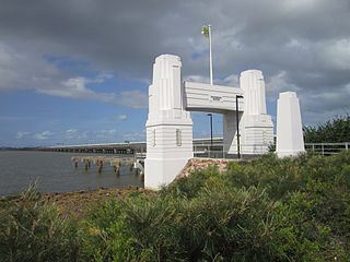
The Ted Smout Memorial Bridge is a road and pedestrian bridge in Brisbane, Australia, the third bridge crossing Hays Inlet in Bramble Bay. It is located 30 metres to the east of the Houghton Highway, providing 3 southbound traffic lanes and a bi-directional pedestrian and bicycle path. It connects the Redcliffe suburb of Clontarf with the Brisbane suburb of Brighton, and was opened by then Queensland Premier Anna Bligh on 11 July 2010. The Ted Smout Memorial Bridge were Australia's second longest bridges until 27 March 2013, when the Macleay River Bridge opened in Kempsey, NSW.

Lockyer Creek Railway Bridge (Lockyer) is a heritage-listed railway bridge on the Toowoomba–Helidon railway line over Lockyer Creek at Lockyer, Lockyer Valley Region, Queensland, Australia. It was designed by William Pagan and built from 1909 to 1910. It was added to the Queensland Heritage Register on 21 October 1992.
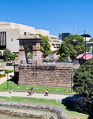
Victoria Bridge Abutment is a heritage-listed road bridge remnant at 74 Stanley Street, South Brisbane, City of Brisbane, Queensland, Australia. It was designed by Alfred Barton Brady and built in 1896 by Arthur Midson. It was added to the Queensland Heritage Register on 21 August 1992.

The James D. Pfluger Pedestrian and Bicycle Bridge is a shared use bridge for pedestrians and cyclists spanning Lady Bird Lake in downtown Austin, Texas. Opened in 2001, the bridge connects the north and south sides of the Ann and Roy Butler Hike-and-Bike Trail and features an unusual "double curve" design. The bridge runs parallel to the Lamar Boulevard Bridge, which carries road traffic across the lake roughly 200 feet (61 m) to the west.

The Neville Bonner Bridge is a footbridge spanning the Brisbane River in Brisbane, Australia, connecting the incomplete Queen's Wharf precinct in the Brisbane central business district to the South Bank Parklands in South Brisbane. The bridge is complete, but not yet open to the public, as it is part of the incomplete Queen's Wharf project, which is projected to open in August 2024.