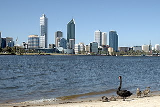
The Swan River is a river in the south west of Western Australia. The river runs through the metropolitan area of Perth, Western Australia's capital and largest city.

Avon Valley is a national park in Western Australia, 47 kilometres northeast of Perth. It was named after the Avon River, which flows through it. The area is an undulating plateau with the sides of the valley steeply sloping back to the river approximately 200 metres (660 ft) below. The area contains granite outcrops and a mix of soil types including loams, gravels and lateritic sands.
Walyunga National Park is a national park in Western Australia, 35 km northeast of Perth along the Great Northern Highway.

Richmond is an inner-city suburb in Melbourne, Victoria, Australia, 3 km (1.9 mi) east of Melbourne's Central Business District, located within the City of Yarra local government area. Richmond recorded a population of 28,587 at the 2021 census.

Mount Lawley is an inner northern suburb of Perth, Western Australia. The suburb is bounded by the Swan River to the east, Vincent, Harold and Pakenham Streets to the south, Central Avenue and Alexander Drive to the north, and Norfolk Street to the west.

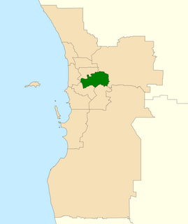
The City of Swan is a local government area of Western Australia. It is in the eastern metropolitan region of Perth and includes the Swan Valley and 42 suburbs. It is centred approximately 20 km north-east of the Perth central business district. The City covers an area of 1,042 km² and had an estimated population of 155,653 in 2020.
The Division of Swan is an Australian electoral division located in Western Australia.

Stratford is a town on the Avon River in Victoria, Australia, 232 kilometres (144 mi) east of Melbourne on the Princes Highway in Shire of Wellington. At the 2006 census, Stratford had a population of 1950. The town services the local regional community and travellers on the Princes Highway. Stratford's principal industries are dairying, sheep, cattle and horse breeding and vegetable crops. The town has numerous coffee shops and cafes, a cellar door for a local winery, Design Gallery, model railway shop, a pub, parks and playgrounds for car travelers to break their journey.

Bellevue is an eastern suburb of Perth, Western Australia in the local government areas of the City of Swan and the Shire of Mundaring. It is at the foot of the slopes of Greenmount, a landmark on the Darling Scarp that is noted in the earliest of travel journals of the early Swan River Colony.

Bicton is an affluent riverside suburb of Perth, Western Australia, located 10 kilometres (6.2 mi) south-west of the central business district. The suburb is mostly residential, and falls within the City of Melville local government area. Bicton borders the Swan River to the north, with the northern third of the suburb taken up by a Class-A reserve at Point Walter.

Ardross is a suburb of Perth, Western Australia, located within the City of Melville. It was once an area of land acquired by the Scotsman, Sir Alexander Percival Matheson in 1896. In Matheson's subdivision of the adjoining suburb of Applecross, he created "Ardross Street" naming it after either the town of Ardrossan on the Scottish west coast or Ardross Castle, located about 40 kilometers north of Inverness. The suburb derives its name from this street.
Embleton is a suburb of Perth, the capital city of Western Australia, located 7 kilometres (4.3 mi) north-east of the central business district, between the suburbs of Morley and Bayswater. Its local government area is the City of Bayswater.

Bentley is a southern suburb of Perth, the capital city of Western Australia, 8 kilometres (5.0 mi) southeast of Perth's central business district. Its local government areas are the City of Canning and the Town of Victoria Park. Bentley is home to the main campus of Curtin University of Technology and Technology Park.

Middle Swan is a suburb of Perth, Western Australia, and forms part of the City of Swan local government area. The suburb is bordered to the west by the Swan River. The suburb is most notable for its various wineries, including Nikola Estate that was once known as Houghton and Sandalford. It also has the Midland brickworks within its boundaries, as well as an accommodation facility for country students attending the Governor Stirling Senior High School and Swan Christian College.

Beechboro is a suburb of Perth, Western Australia, located within the City of Swan.
Viveash is an eastern suburb of Perth, Western Australia, in the City of Swan. It was named after Samuel Waterman Viveash, the owner of the land in this area in the 1840s. He came to the Swan River Colony on Britomart, which sailed from Spithead on 3 July 1838 and arrived at Fremantle on 5 December 1838, and took up land in the Avon Land District. A copy of Viveash's diaries for the period 1838 to 1851 can be accessed at the University of Western Australia Library. The suburban area of Viveash was developed by Midland Brick, which carried out subdivision in 1967, and requested in 1968 that the area be named after Viveash.

East Fremantle is a suburb of Perth, Western Australia, located 13 kilometres (8.1 mi) south-west of the central business district. The suburb is mainly residential, and is coterminous with the Town of East Fremantle local government area.
Mosman Park is a western suburb of Perth, Western Australia on the north bank of the Swan River in the local government area of the Town of Mosman Park. It was historically known as Buckland Hill (1889-1909), then Cottesloe Beach (1909-1930) and again Buckland Hill (1930-1937). From 1937 it was named Mosman Park, derived from Mosman in Sydney, the birthplace of Richard Yeldon, a member of the Buckland Hill Road Board. Mosman Park is now considered an affluent suburb, but prior to the 1970s was one of Perth's major industrial centres.

Bayswater is a suburb 6 km (4 mi) north-east of the central business district (CBD) of Perth, the capital of Western Australia. It is just north of the Swan River, within the City of Bayswater local government area. It is predominantly a low-density residential suburb consisting of single-family detached homes. However, there are several clusters of commercial buildings, most notably in the suburb's town centre, around the intersection of Whatley Crescent and King William Street and a light industrial area in the suburb's east.
Aveley is a suburb of Perth, Western Australia, east of Ellenbrook and south of The Vines. In 1897 George Hardey Barrett Lennard, grandson of Edward Pomeroy Barrett-Lennard, purchased a property in the area of which is now Aveley, naming it "Belhus" after his family's estate in Belhus, Essex, England. The name "Aveley", deriving from the eponymous town where the estate was located, was approved as a suburb name on 6 September 2006, before which the area was part of Ellenbrook. It is bordered by Gnangara Road and Lake Yakine to the south, a small part of West Swan Road, the Ellen Brook and Chateau Place to the east, The Broadway, Doig Road, and Cashman Avenue to the north, and Henley Brook Avenue to the west. The suburb is accessible from Henley Brook Avenue, The Promenade, Gnangara Road, and West Swan Road.

