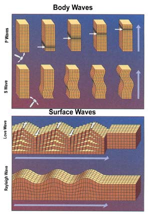
A seismic wave is a wave of acoustic energy that travels through the Earth or another planetary body. It can result from an earthquake, volcanic eruption, magma movement, a large landslide, and a large man-made explosion that produces low-frequency acoustic energy. Seismic waves are studied by seismologists, who record the waves using seismometers, hydrophones, or accelerometers. Seismic waves are distinguished from seismic noise, which is persistent low-amplitude vibration arising from a variety of natural and anthropogenic sources.
Petroleum geology is the study of origin, occurrence, movement, accumulation, and exploration of hydrocarbon fuels. It refers to the specific set of geological disciplines that are applied to the search for hydrocarbons.

Hydrocarbon exploration is the search by petroleum geologists and geophysicists for deposits of hydrocarbons, particularly petroleum and natural gas, in the Earth's crust using petroleum geology.

Reflection seismology is a method of exploration geophysics that uses the principles of seismology to estimate the properties of the Earth's subsurface from reflected seismic waves. The method requires a controlled seismic source of energy, such as dynamite or Tovex blast, a specialized air gun or a seismic vibrator. Reflection seismology is similar to sonar and echolocation. This article is about surface seismic surveys; for vertical seismic profiles, see VSP.

In geophysics and reflection seismology, amplitude versus offset (AVO) or amplitude variation with offset is the general term for referring to the dependency of the seismic attribute, amplitude, with the distance between the source and receiver. AVO analysis is a technique that geophysicists can execute on seismic data to determine a rock's fluid content, porosity, density or seismic velocity, shear wave information, fluid indicators.
Exploration geophysics is an applied branch of geophysics and economic geology, which uses physical methods, such as seismic, gravitational, magnetic, electrical and electromagnetic at the surface of the Earth to measure the physical properties of the subsurface, along with the anomalies in those properties. It is most often used to detect or infer the presence and position of economically useful geological deposits, such as ore minerals; fossil fuels and other hydrocarbons; geothermal reservoirs; and groundwater reservoirs.
Petrophysics is the study of physical and chemical rock properties and their interactions with fluids.
Seismic migration is the process by which seismic events are geometrically re-located in either space or time to the location the event occurred in the subsurface rather than the location that it was recorded at the surface, thereby creating a more accurate image of the subsurface. This process is necessary to overcome the limitations of geophysical methods imposed by areas of complex geology, such as: faults, salt bodies, folding, etc.
Rayleigh waves are a type of surface acoustic wave that travel along the surface of solids. They can be produced in materials in many ways, such as by a localized impact or by piezo-electric transduction, and are frequently used in non-destructive testing for detecting defects. Rayleigh waves are part of the seismic waves that are produced on the Earth by earthquakes. When guided in layers they are referred to as Lamb waves, Rayleigh–Lamb waves, or generalized Rayleigh waves.
In geophysics, seismic inversion is the process of transforming seismic reflection data into a quantitative rock-property description of a reservoir. Seismic inversion may be pre- or post-stack, deterministic, random or geostatistical; it typically includes other reservoir measurements such as well logs and cores.
A synthetic seismogram is the result of forward modelling the seismic response of an input earth model, which is defined in terms of 1D, 2D or 3D variations in physical properties. In hydrocarbon exploration this is used to provide a 'tie' between changes in rock properties in a borehole and seismic reflection data at the same location. It can also be used either to test possible interpretation models for 2D and 3D seismic data or to model the response of the predicted geology as an aid to planning a seismic reflection survey. In the processing of wide-angle reflection and refraction (WARR) data, synthetic seismograms are used to further constrain the results of seismic tomography. In earthquake seismology, synthetic seismograms are used either to match the predicted effects of a particular earthquake source fault model with observed seismometer records or to help constrain the Earth's velocity structure. Synthetic seismograms are generated using specialized geophysical software.
In reflection seismology, a seismic attribute is a quantity extracted or derived from seismic data that can be analysed in order to enhance information that might be more subtle in a traditional seismic image, leading to a better geological or geophysical interpretation of the data. Examples of seismic attributes can include measured time, amplitude, frequency and attenuation, in addition to combinations of these. Most seismic attributes are post-stack, but those that use CMP gathers, such as amplitude versus offset (AVO), must be analysed pre-stack. They can be measured along a single seismic trace or across multiple traces within a defined window.

Geothermal exploration is the exploration of the subsurface in search of viable active geothermal regions with the goal of building a geothermal power plant, where hot fluids drive turbines to create electricity. Exploration methods include a broad range of disciplines including geology, geophysics, geochemistry and engineering.
In reflection seismology, a dim spot is a local low-amplitude seismic attribute anomaly that can indicate the presence of hydrocarbons and is therefore known as a direct hydrocarbon indicator. It primarily results from the decrease in acoustic impedance contrast when a hydrocarbon replaces the brine-saturated zone that underlies a shale, decreasing the reflection coefficient.
In reflection seismology, a polarity reversal or phase change is a local amplitude seismic attribute anomaly that can indicate the presence of hydrocarbons and is therefore known as a direct hydrocarbon indicator. It primarily results from the change in polarity of the seismic response when a shale overlies a brine-saturated zone, that becomes invaded with an oil/gas sand. This changes the acoustic impedance contrast from an increase to a decrease, resulting in the polarity of the seismic response being reversed - as per the normal convention adopted by the SEG.
In reflection seismology, the anelastic attenuation factor, often expressed as seismic quality factor or Q, quantifies the effects of anelastic attenuation on the seismic wavelet caused by fluid movement and grain boundary friction. As a seismic wave propagates through a medium, the elastic energy associated with the wave is gradually absorbed by the medium, eventually ending up as heat energy. This is known as absorption and will eventually cause the total disappearance of the seismic wave.
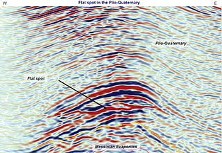
In reflection seismology, a flat spot is a seismic attribute anomaly that appears as a horizontal reflector cutting across the stratigraphy elsewhere present on the seismic image. Its appearance can indicate the presence of hydrocarbons. Therefore, it is known as a direct hydrocarbon indicator and is used by geophysicists in hydrocarbon exploration.
A hydrocarbon indicator (HCI) or direct hydrocarbon indicator (DHI), is an anomalous seismic attribute value or pattern that could be explained by the presence of hydrocarbons in an oil or gas reservoir.
Bottom simulating reflectors (BSRs) are, on seismic reflection profiles, shallow seismic reflection events, characterized by their reflection geometry similar to seafloor bathymetry. . They have, however, the opposite reflection polarity to the seabed reflection, and frequently intersect the primary reflections.
Seismic stratigraphy is a method for studying sedimentary rock in the deep subsurface based on seismic data acquisition.
