Brim Fell

Last updated
Brim Fell
Brim fell summit.jpg
Brim Fell summit
Highest point
Elevation 796 m (2,612 ft)
Prominence c. 25 m
Parent peak The Old Man of Coniston
Listing Wainwright, Nuttall
Coordinates 54°22′40″N3°07′26″W / 54.37766°N 3.12381°W / 54.37766; -3.12381 Coordinates: 54°22′40″N3°07′26″W / 54.37766°N 3.12381°W / 54.37766; -3.12381
Geography
Lake District National Park UK relief location map.png
Red triangle with thick white border.svg
Brim Fell
Location in Lake District, UK
Location Cumbria, England
Parent range Lake District, Southern Fells
OS grid SD271986
Topo map OS Landranger 89,90, Explorer OL6

Brim Fell is a fell in the English Lake District. It stands to the west of Coniston village in the southern part of the District.

Contents

Topography

The Coniston (or Furness) Fells form the watershed between Coniston Water and the Duddon valley to the west. The range begins in the north at Wrynose Pass and runs south for around 10 miles before petering out at Broughton in Furness on the Duddon Estuary. Alfred Wainwright in his influential Pictorial Guide to the Lakeland Fells took only the northern half of the range as Lakeland proper, consigning the lower fells to the south to a supplementary work The Outlying Fells of Lakeland. Brim Fell occupies a position in the northern section and therefore qualifies as one of the 214 Wainwrights. Later, guidebook writers have chosen to include the whole range in their main volumes. [1] [2]

The higher northern part of the Coniston range can be likened to an inverted 'Y' with Brim Fell at the connecting point of the three arms. To the north are Swirl How, Great Carrs and Grey Friar, south east is the short spur terminating at The Old Man of Coniston and to the south west the range continues over Dow Crag to the lower hills beyond.

Brim Fell is unusual in having no footing on the valley floor on either side of the ridge. On the east its boundary streams converge at 800 ft and the flanks of Coniston Old Man and Wetherlam continue to the lake. Above the Duddon, Brim Fell is nipped off by Dow Crag and Grey Friar at an even greater altitude. The area of the fell is therefore small, but full of interest.

The western slopes are relatively smooth and fall to Tarn Head Beck. This runs parallel to the ridge and is the main feeder of Seathwaite Tarn, a reservoir in a side valley of the Duddon system. This was originally a much smaller waterbody, but was dammed early in the 20th century to provide drinking water for the Barrow-in-Furness area. The dam is almost 400 yards long and is concrete cored with slate buttresses, the resulting depth of the tarn being around 80 ft. Water is not abstracted directly from the tarn, but flows some distance downriver to an off-take weir. [3] On the slopes of Brim Fell, above the head of the reservoir, are the remains of Seathwaite Tarn Mine. This was worked for copper in the mid-19th century, and also appears as a location in the novel The Plague Dogs by Richard Adams. [4]

The ridge north from Brim Fell narrows to the depression at Levers Hawse (2,250 ft) before climbing again over the rougher ground of Great How Crags to the summit of Swirl How. To the south, trending south east across a broad plateau is The Old Man of Coniston, the reascent being negligible. Halfway between Brim Fell and 'The Old Man' a further ridge branches off due west, dropping steeply to Goat's Hawse (2,130 ft), before swinging south around Goat's Water to Dow Crag.

In contrast to the western slopes and ridge-top grass promenade, the Coniston face is all crag. A short high level spur juts out from the summit, ending in the shattered cliffs of Raven Tor. To either side of this promontory is a corrie tarn, Low Water to the south and Levers Water to the north. Low Water is the smaller, its depth increased by a stone faced dam built by the nearby slate quarries. The outflow drops via a fine waterfall to join Levers Water Beck a mile down stream. Levers Water was also dammed in times past for industrial use (in this case the Coniston Coppermines), but now provides domestic supply for Coniston village. The stone faced dam has increased its depth to some 125 ft. [3] Running parallel to the ridge below Low Water is an unusual lateral valley, named "Boulder Valley" on Ordnance Survey maps due to the number of large erratics on its floor.

Geology

The summit is formed from the bedded andesitic tuff and andesite of the Duddon Hall Formation. Working northwards up the ridge the rhyolitic tuffs and lapilli tuffs of the Long Top Member are revealed. Rhyolitic tuffs also make up the Paddy End Member in the Coppermines Valley. [5]

The valley of Levers Water Beck below Brim Fell holds part of the Coniston Coppermines, a huge complex of shafts and tunnels extending over a square mile. The mine was at its most productive in the 1850s, declining in output until closure in 1915. Since then there have been occasional attempts at reopening, principally in 1954, but tourism has gradually taken over as the main activity in the valley. The mines exploited a number of veins, the copper-bearing mineral chalcopyrite being the main ore, although some nickel, cobalt and lead were also extracted. The Paddy End section of the mine on the lower slopes of Brim Fell was the most productive, with levels passing beneath the bed of Levers Water. Simons Nick, a large (and dangerous) multi-shaft opening above the dam is the most obvious remaining feature. [4]

Summit

The summit of Brim Fell bears a fine slate cairn on grass, with a second big cairn to the north east. The views are extensive although the long whale-backed ridge tends to limit the foreground. [6]

Ascents

Direct ascents are perhaps unusual, most walkers traversing from "The Old Man" to Swirl How, but perfectly possible. The easiest access is from Coniston, climbing via Levers Water to Levers Hawse. Pathless ascents of Raven Tor can also be made from either side for a wilder finish. The Walna Scar Road (Byway open to all traffic) [7] gives access to Goat's Hawse from either side of the ridge and this is the easiest route from the Duddon. Note that a right of way shown on Ordnance Survey maps descending west from Levers Hawse to Seathwaite Tarn does not exist as a path on the ground. [1]

Related Research Articles

Old Man of Coniston

The Old Man of Coniston is a fell in the Furness Fells in the English Lake District and the highest point of the traditional County Palatine of Lancashire. It is at least 2,632.61 feet (802.42 m) high, and lies to the west of the village of Coniston and the lake, Coniston Water. The fell is sometimes known by the alternative name of Coniston Old Man, or simply The Old Man. The mountain is popular with tourists and fell-walkers with a number of well-marked paths to the summit. The mountain has also seen extensive copper and slate mining activity for eight hundred years and the remains of abandoned mines and spoil tips are a significant feature of the north-east slopes. There are also several flocks of sheep that are grazed on the mountain.

Great Gable

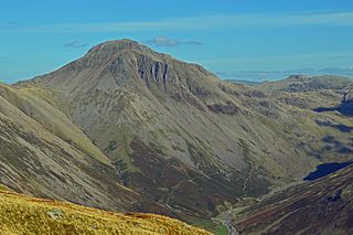
Great Gable is a mountain in the Lake District, United Kingdom. It is named for its appearance as a pyramid from Wasdale, though it is dome-shaped from most other directions. It is one of the most popular of the Lakeland fells, and there are many different routes to the summit. Great Gable is linked by the high pass of Windy Gap to its smaller sister hill, Green Gable, and by the lower pass of Beck Head to its western neighbour, Kirk Fell.

Hard Knott Fell in the Lake District, Cumbria, England

Hard Knott is a fell in the English Lake District, at the head of Eskdale.

Harter Fell (Eskdale) Fell in the Lake District, Cumbria, England

Harter Fell is a fell in the western part of the English Lake District, located between the Eskdale and Duddon valleys. Its height is 649 m (2128 ft). There are several walking routes to the summit.

Cold Pike Fell in the Lake District, Cumbria, England

Cold Pike is a fell in the English Lake District. It is a satellite of Crinkle Crags and stands above the Upper Duddon Valley.

White Side

White Side is a fell in the English Lake District. It is situated to the east of Thirlmere and to the west of Glenridding valley. This places White Side in the Helvellyn range of the Eastern Fells, with Raise to the north and Helvellyn Lower Man to the south, both of which are of greater height.

Holme Fell

Holme Fell or Holm Fell is a fell in the Lake District in Cumbria, England. It is located between Coniston Water and Little Langdale, almost isolated from the neighbouring Coniston Fells by Yewdale Beck.

Pike of Blisco

Pike of Blisco, or Pike o' Blisco, is a mountain in the Lake District in Cumbria, England. Located between the valleys of Great Langdale and Little Langdale, its relative isolation from neighbouring fells together with slopes falling away immediately from the summit in all directions mean it has excellent views: the view of the Langdale Pikes across Great Langdale is particularly arresting.

Furness Fells

The Furness Fells are a multitude of hills and mountains in the Furness region of Cumbria, England. Historically part of Lancashire, the Furness Fells or High Furness is the name given to the upland part of Furness, that is, that part of Furness lying north of the line between Ulverston and Ireleth. The hills lie largely within the English Lake District.

Base Brown

Base Brown is a fell in England's Lake District, near the head of the Borrowdale Valley. It forms one side of the Seathwaite Valley, and on the western side it is flanked by the hanging valley of Gillercomb.

Dow Crag Fell in the Lake District, Cumbria, England

Dow Crag is a fell in the English Lake District near Coniston, Cumbria. The eastern face is one of the many rock faces in the Lake District used for rock climbing.

Green Gable

Green Gable is a fell in the English Lake District often traversed by walkers en route to its more famous neighbour Great Gable. It can be ascended from Honister Pass, Seathwaite in Borrowdale, or Ennerdale. There are good views of Gable Crag, Scafell Pike and the Buttermere valley from the summit.

Grey Friar Fell in the Lake District, Cumbria, England

Grey Friar is a fell in the English Lake District, it is one of the Coniston Fells and is situated 13 kilometres west-south-west of Ambleside. It reaches a height of 770 metres and stands to the north west of the other Coniston Fells, a little off the beaten track and tends to be the least visited of the group. It is quite a large fell and forms the eastern wall of the Duddon Valley for several kilometres, in fact all drainage from Grey Friar goes to the Duddon Valley and not to Coniston Water.

Wetherlam

Wetherlam is a mountain in the English Lake District. It is the most northerly of the Coniston Fells, the range of fells to the north-west of Coniston village; its north-east slopes descend to Little Langdale.

Swirl How Fell in the Lake District, Cumbria, England

Swirl How is a fell in the English Lake District. It stands between Coniston and the Duddon Valley in the southern part of the District. It rivals the Old Man of Coniston as the highest point within the traditional County Palatine of Lancashire.

Black Fell (Lake District)

Black Fell is a fell in the English Lake District. It rises to the north of Tarn Hows, between Coniston and Hawkshead.

Great Carrs Fell in the Lake District, Cumbria, England

Great Carrs is a fell in the English Lake District. It stands above Wrynose Pass in the southern part of the District.

Green Crag

Green Crag is a fell in the English Lake District. It stands between Eskdale and the Duddon valley in the Southern Fells.

Southern Fells

The Southern Fells are a group of hills in the English Lake District. Including Scafell Pike, the highest peak in England, they occupy a broad area to the south of Great Langdale, Borrowdale and Wasdale. High and rocky towards the centre of the Lake District, the Southern Fells progressively take on a moorland character toward the south west. In the south east are the well known Furness Fells, their heavily quarried flanks rising above Coniston Water.

Levers Water

Levers Water is a small lake in the English Lake District. It is located at the head of the Coppermines Valley, above Coniston village. To its south-west is Raven Tor, a spur of Brim Fell, and to its north-west are Little How Crags and Great How Crags, on the eastern side of the north-south ridge leading to Swirl How.

References

  1. 1 2 Richards, Mark: Southern Fells: Collins (2003): ISBN   0-00-711367-6
  2. Birkett, Bill: Complete Lakeland Fells: Collins Willow (1994): ISBN   0-00-218406-0
  3. 1 2 Blair, Don: Exploring Lakeland Tarns: Lakeland Manor Press (2003): ISBN   0-9543904-1-5
  4. 1 2 Adams, John: Mines of the Lake District Fells: Dalesman (1995) ISBN   0-85206-931-6
  5. British Geological Survey: 1:50,000 series maps, England & Wales Sheet 38: BGS (1998)
  6. Alfred Wainwright: A Pictorial Guide to the Lakeland Fells , Book 4: ISBN   0-7112-2457-9
  7. "Rights of Way Orders by Lake District National Park Authority 2009" . Retrieved 2009-12-31.