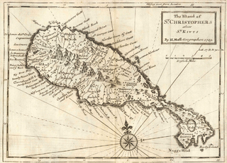
Saint Kitts and Nevis, officially the Federation of Saint Christopher and Nevis, is an island country and microstate consisting of the two islands of Saint Kitts and Nevis, both located in the West Indies, in the Leeward Islands chain of the Lesser Antilles. With 261 square kilometres (101 sq mi) of territory, and roughly 50,000 inhabitants, it is the smallest sovereign state in the Western Hemisphere, in both area and population, as well as the world's smallest sovereign federation. The country is a Commonwealth realm, with Charles III as King and head of state. It is the only sovereign federation in the Caribbean.
Saint Kitts and Nevis have one of the longest written histories in the Caribbean, both islands being among Spain's and England's first colonies in the archipelago. Despite being only two miles apart and quite diminutive in size, Saint Kitts and Nevis were widely recognized as being separate entities with distinct identities until they were forcibly united in the late 19th century.

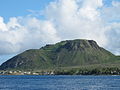
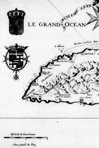
Saint Kitts, officially Saint Christopher, is an island in the West Indies. The west side of the island borders the Caribbean Sea, and the eastern coast faces the Atlantic Ocean. Saint Kitts and the neighbouring island of Nevis constitute one country: the Federation of Saint Kitts and Nevis. Saint Kitts and Nevis are separated by a shallow 3-kilometre (2 mi) channel known as "The Narrows".

The Battle of Saint Kitts, also known as the Battle of Frigate Bay, was a naval battle fought on 25 and 26 January 1782 during the American Revolutionary War between a British fleet under Rear Admiral Sir Samuel Hood and a larger French fleet under the Comte de Grasse.
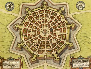
A bastion fort or trace italienne is a fortification in a style that evolved during the early modern period of gunpowder when the cannon came to dominate the battlefield. It was first seen in the mid-fifteenth century in Italy. Some types, especially when combined with ravelins and other outworks, resembled the related star fort of the same era.

Saint Thomas Middle Island is one of 14 administrative parishes that make up Saint Kitts and Nevis. It is the third largest parish on the island of Saint Kitts, and fourth largest in the federation. The parish capital is Middle Island.
Fort Charles, also called Cleverley Point Fort, is a historic British colonial fort site on the island of St. Kitts, located in the present day nation of Saint Kitts and Nevis in the Caribbean.

Fort Charles is an abandoned British fort on the island of Nevis. It is now mostly in ruins.

Sandy Point is the second largest town in the island of Saint Kitts, Saint Kitts and Nevis. This town is situated on the north-west coast of St.Kitts and is the capital of Saint Anne Sandy Point Parish.
The monarchy of Saint Kitts and Nevis is a system of government in which a hereditary monarch is the sovereign and head of state of Saint Kitts and Nevis. The current monarch of Saint Kitts and Nevis, since 8 September 2022, is King Charles III. As sovereign, he is the personal embodiment of the Crown of Saint Kitts and Nevis. Although the person of the sovereign is equally shared with 14 other independent countries within the Commonwealth of Nations, each country's monarchy is separate and legally distinct. As a result, the current monarch is officially titled King of Saint Christopher and Nevis and, in this capacity, he and other members of the royal family undertake public and private functions domestically and abroad as representatives of Saint Kitts and Nevis. However, the King is the only member of the royal family with any constitutional role.

The fortifications of Kotor are an integrated historical fortification system that protected the medieval town of Kotor containing ramparts, towers, citadels, gates, bastions, forts, cisterns, a castle, and ancillary buildings and structures. They incorporate military architecture of Illyria, the Byzantine Empire, Venice, and Austria. Together with the old town and its natural surroundings the fortifications were inscribed in the list of World Heritage Sites in 1979 labelled Natural and Culturo-Historical Region of Kotor and represent the only such site of cultural significance in Montenegro.
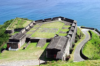
The French invasion of Saint Kitts also known as the siege of Brimstone Hill, from 19 January–13 February 1782, was a part of the American Revolutionary War. After landing on Saint Kitts, the French troops of the Marquis de Bouillé stormed and besieged the fortress of Brimstone Hill. After a month of battle, the heavily outnumbered and cut-off British garrison surrendered. The Comte de Grasse, who delivered de Bouillé's troops and supported the siege, was outmanoeuvred and deprived of his anchorage by Admiral Samuel Hood. Even though Hood's force was inferior by one-third, de Grasse was beaten off when he attempted to dislodge Hood. Hood's attempts to relieve the ongoing siege were unsuccessful, and the garrison capitulated after one month. About a year later, the Treaty of Paris restored Saint Kitts and adjacent Nevis to British rule.
The Capture of Montserrat was accomplished by a French naval expedition that seized the island of Montserrat from the British on 22 February 1782 during the American Revolutionary War.
The French cutter Espion was a cutter launched in 1781. The British captured her and took her in 1782 into the Royal Navy as HMS Espion. The Royal Navy sold her in 1783.

The French settlement of St. Kitts and Nevis started in the early seventeenth century. Throughout its history on Saint Kitts until the nineteenth century, France had frequent clashes with the English for the occupation of the island, until its final defeat in 1782, which definitely gave the island to the British. Today, the descendants of French make up a portion of the white population of the archipelago.

The Lines of Contravallation of Gibraltar, known in English as the "Spanish Lines", were a set of fortifications built by the Spanish across the northern part of the isthmus linking Spain with Gibraltar. They later gave their name to the Spanish town of La Línea de la Concepción. The Lines were constructed after 1730 to establish a defensive barrier across the peninsula, with the aim of preventing any British incursions, and to serve as a base for fresh Spanish attempts to retake Gibraltar. They played an important role in the Great Siege of Gibraltar between 1779 and 1783 when they supported the unsuccessful French and Spanish assault on the British-held fortress. The siege was ended after the lines of contravallation were attacked by British and Dutch forces under the command of the Governor of Gibraltar, General Augustus Eliot. The attack caused the Spanish forces to retreat and abandon the fortifications and the combined British led forces virtually destroyed all the Spanish gun batteries and the enemy cannon and munitions either captured or destroyed. This attack is still commemorated to this day and is known as 'Sortie Day'.

The New Fortress of Corfu is a Venetian fortress built on the hill of St. Mark in Corfu in stages. The original architect of the fort was the military engineer Ferrante Vitelli. The current buildings which exist within the fortress were built by the British during their rule of the island (1815–63).
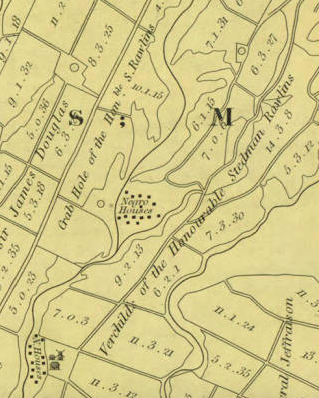
Hon. Stedman Rawlins (c.1784–1830) was a slaveholder and sugar plantation owner, and the President of His Majesty's Council, on the Caribbean island of St. Christopher.