
Kingston is a village and a census-designated place within the town of South Kingstown in Washington County, Rhode Island, United States, and the site of the main campus of the University of Rhode Island. The population was 6,974 at the 2010 census. Much of the village center is listed on the National Register of Historic Places as Kingston Village Historic District. It was originally known as Little Rest.
Watch Hill is an affluent coastal neighborhood and census-designated place in the town of Westerly, Rhode Island. The population was 154 at the 2010 census. It sits at the most-southwestern point in Rhode Island. It came to prominence in the late 19th and early 20th century as an exclusive summer resort, with wealthy families building sprawling Victorian-style "cottages" along the peninsula. Watch Hill is characterized by The New York Times as a community "with a strong sense of privacy and of discreetly used wealth," in contrast with "the overpowering castles of the very rich" in nearby Newport.

Saunderstown is a small village and historic district in the towns of Narragansett and North Kingstown in Washington County, Rhode Island, United States. Saunderstown has its own post office with the ZIP Code of 02874, which also includes a small part of South Kingstown. Its population is 6,245.
Oakland is a village in Burrillville, Providence County, Rhode Island, United States. It was developed in the 19th century at the site of a stone mill near the confluence of the Chepachet and Clear Rivers. It is one of the few remaining stone mills in this state. Most of the village is included in the Oakland Historic District, a historic district listed on the National Register of Historic Places. Most of the housing in the village was originally built to house mill workers, although there are several more elaborate houses built for mill executives.
Lonsdale is a village and historic district in Lincoln and Cumberland, Providence County, Rhode Island, United States, near Rhode Island Route 146 and Route 95. The village was originally part of the town of Smithfield until Lincoln was created in the 1870s, and was originally centered on the Lincoln side of the Blackstone River. William Blaxton settled in the area in 1635. In the nineteenth and early twentieth centuries, Lonsdale was home to several manufacturers including the Lonsdale Company's Bleachery, and the Ann & Hope mill was also located in the village in Cumberland.

Barrington Civic Center Historic District is a historic district in Barrington, Rhode Island on County Road. The district, which consists of the Barrington Town Hall, Leander R. Peck School and Prince's Hill Cemetery, is located on Prince's Hill near the center of Barrington. In 1728, Prince's Hill Cemetery was purchased and later expanded to its present size by 1898. The 1+1⁄2-story Barrington Town Hall was completed in 1888 and originally served as the seat of the town's government, library and high school. With the completion of the Leander R. Peck School in 1917, the high school moved into the adjacent building and the library used its space. The two-story Elizabethan Revival style Peck School is designed with a T-shaped plan and features a stairway to access the main entrance on the second story. The Peck School was later used by the fifth and sixth-grade elementary students before becoming the public library. Also located within the district is Wood's Pond. The Barrington Civic Center Historic District was added to the National Register of Historic Places in 1976 and serves as a historically significant example of civic and natural environment planning of the late nineteenth century.


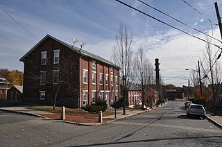
The Warren Waterfront Historic District encompasses the center of Warren, Rhode Island. It is bounded on the west by the Warren River, on the north roughly by Belcher Cove, on the east roughly by Federal and Main Streets, and on the south by Campbell Street. This area is a densely built residential, commercial, and civic area that has been the center of Warren since the mid-18th century. The town prospered in the 19th century, first as a whaling and shipbuilding center and later with industrial development. The district includes the town's major civic buildings, as well as a wide variety of housing in 19th century revival and Victorian styles. It was listed on the National Register of Historic Places in 1974, and enlarged in 2003.

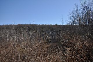
Arnold Mills Historic District is a historic district encompassing a modest 19th-century mill village in eastern Cumberland, Rhode Island. The district lies along the Nate Whipple Highway and Sneech Pond Road, south of the Arnold Mills Reservoir. Sneech Pond Road was formerly the major east-west highway through the area prior to the construction of the Nate Whipple Highway in the 1960s. The Arnold Mills village is in part bisected by Abbott Run, the stream which serves as the outlet of the reservoir; Sneech Pond Road crosses the run on an early 20th-century steel Pratt pony truss, now closed to vehicular traffic. The houses along this road generally date from the late 18th to mid-19th century, and mainly reflect Federal and Greek Revival styling. The most prominent structure in the district is the Arnold Mills United Methodist Church, located at the western end of the district on Nate Whipple Highway; it was built 1825-27 and remodeled in 1846.

The Brown Avenue Historic District is a rural historic district in Johnston, Rhode Island, USA. The district encompasses a rural and agricultural landscape centered on a 1-mile (1.6 km) stretch in the midsection of Brown Avenue, which runs between Hartford Avenue and Greenville Avenue. There are five farmsteads, with the Dame Farmstead at its center, whose farmhouses date to the late 18th century. A number of these farms are no longer in production, and part of the district is in Snake Den State Park.

The Wayland Historic District is a predominantly residential historic district on the east side of Providence, Rhode Island. It is a large area, covering about 122 acres (49 ha), bounded roughly on the north by Everett and Laurel Avenues, on the east by Blackstone Boulevard and Butler Avenue, on the west by Arlington Avenue, and on the south by Angell and South Angell Streets. This area, which was in the 19th century part of the Moses Brown farm, was platted for development in 1891, with most of the construction taking place in the early decades of the 20th century. Most of the residential properties in the district are single-family houses, typically built in revival styles popular at the time. They are set on similarly sized lots with fairly uniform setbacks, and were typically built without garages. There are a number of two-family houses, and a small number of apartment buildings, most of which are found on the arterial roads of the area. There are several religious buildings, including several churches; the most architecturally distinctive religious building is the Jewish Temple Beth El, built 1951–54.

East Greenwich Historic District is a historic district encompassing the historic commercial and civic heart of East Greenwich, Rhode Island, United States. The district bounded on the east by Greenwich Cove, an inlet on Narrangansett Bay, on the south by London and Spring Streets, on the west roughly by Park Street, and on the north by Division Street. The district extends westward on Division Street as far Dark Entry Brook, and the district properties on its north side now lie in the city of Warwick. East Greenwich was settled in 1677 with its town center growing in the district, with a rural farm landscape to the west. The area's road network had begun to take shape by the mid-18th century, and the town center was industrialized in the 19th century.
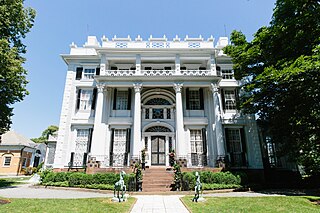
Linden Place mansion is a Federal-style mansion located in Bristol, Rhode Island. It was built in 1810 by slave trader, merchant, privateer and ship owner General George DeWolf and was designed by architect, Russell Warren. The mansion now operates as a historic house museum.

The Southern Thames Historic District encompasses the commercial and residential area immediately to the south of the colonial center of Newport, Rhode Island. This area, covering about 135 acres (55 ha), was developed both residentially and commercially between about 1850 and 1920, with the majority of its growth coming in the late 19th century. It is characterized by densely built streets, including Thames Street, Newport's major north–south thoroughfare. The district includes the southern portion of Newport's waterfront, extending south from Memorial Boulevard along Thames and Spring Streets to Morton Street, and west to Marchant Street in its southernmost section. The district's housing stock and commercial architecture are largely vernacular wood-frame structures, set close to the sidewalk on small lots. The waterfront area is composed of wharves with warehouses and other structures, many of which have been converted to commercial use. One of the most prominent buildings in the district is the Emmanuel Episcopal Church, designed by Ralph Adams Cram and built in 1912–13.

The Front Street Historic District in Exeter, New Hampshire, encompasses a portion of the town's historic center. The district extends from Swasey Pavilion, at the junction of Front and Water streets, southwesterly along Front Street to Gale Park, about five blocks. Front Street is one of Exeter's oldest roads, and is lined with a series of 18th and 19th-century civic, religious, and residential structures, many of which are well preserved. The district was listed on the National Register of Historic Places (NRHP) in 1973.

Anthony is a village along Route 117 within the town of Coventry, Rhode Island near the villages of Washington and Quidnick on the southwestern banks of the Pawtuxet River. The village comprises "Anthony, Arnold, Boston, Mapledale, Meeting, Taft, Washington and Laurel Avenue."

The Bristol Downtown Historic District encompasses the historic late 19th-century commercial heart of Bristol, Vermont. At first a rural agricultural market town, it developed in the second half of the 19th century as a small industrial center, producing finished wood products. Its downtown occupies an area of one block on both sides of Main Street, and features a diversity of architectural styles. It was listed on the National Register of Historic Places in 1983.

The City Hall Park Historic District encompasses one of the central economic, civic, and public spaces of the city of Burlington, Vermont. Centered on City Hall Park, the area's architecture encapsulates the city's development from a frontier town to an urban commercial center. The district was listed on the National Register of Historic Places in 1983.

The Samuel Clarke House is a residential structure dating to c. 1691. It's one of the earliest surviving houses in the State of Rhode Island. It is the central building of the “Samuel Clarke Farm”, now a 40-acre parcel in Kenyon, Rhode Island, within the Town of Richmond. The farm is bordered to the west by the Beaver River. This property was originally part of a larger parcel that was sold in 1662 by the Niantic Sachem Wanumachon. This historic land transaction is known as the Stanton Purchase.

The Portsmouth Downtown Historic District encompasses the historic urban core of Portsmouth, New Hampshire. With a history dating to the 17th century, Portsmouth was New Hampshire's principal seaport and the center of its economy for many decades, and the architecture of its urban center is reflective of nearly four centuries of history. The district is roughly L-shaped, radiating from the downtown Market Square area to South Street in the south and Madison and Columbia streets in the west, with more than 1,200 historically significant buildings. It was listed on the National Register of Historic Places in 2017. The district includes 35 previous listings on the National Register, and five National Historic Landmarks.


