National Register of Historic Places listings in Bristol County, Rhode Island

Last updated

Location of Bristol County in Rhode Island Map of Rhode Island highlighting Bristol County.svg
Location of Bristol County in Rhode Island

This is a list of the National Register of Historic Places listings in Bristol County, Rhode Island.

Contents

This is intended to be a complete list of the properties and districts on the National Register of Historic Places in Bristol County, Rhode Island, United States. Latitude and longitude coordinates are provided for many National Register properties and districts; these locations may be seen together in a map. [1]

There are 24 properties and districts listed on the National Register in the county, including one National Historic Landmark.

Current listings


    This National Park Service list is complete through NPS recent listings posted July 1, 2022. [2]

[3] Name on the Register [4] ImageDate listed [5] Location City or townDescription
1 Alfred Drowne Road Historic District
Alfred Drowne Road Historic District BarringtonRI AlfredDrowneRoad 2.jpg
Alfred Drowne Road Historic District
June 10, 2005
(#05000584)
Alfred Drowne Rd., Annawamscutt Rd., Washington Rd.
41°44′38″N71°20′38″W / 41.743889°N 71.343889°W / 41.743889; -71.343889 (Alfred Drowne Road Historic District)
Barrington
2 Allen-West House
Allen-West House BarringtonRI AllenWestHouse.jpg
Allen-West House
December 3, 2013
(#13000887)
153 George St.
41°46′19″N71°18′44″W / 41.771912°N 71.31229°W / 41.771912; -71.31229 (Allen-West House)
Barrington
3 Barrington Civic Center
Barrington Civic Center Barrington RI Town Hall in 2008.jpg
Barrington Civic Center
December 12, 1976
(#76000198)
County Rd.
41°44′29″N71°18′33″W / 41.741389°N 71.309167°W / 41.741389; -71.309167 (Barrington Civic Center)
Barrington
4 Belton Court
Belton Court Belton Court Barrington RI 2012.jpg
Belton Court
June 30, 1976
(#76000037)
Middle Highway
41°45′36″N71°19′57″W / 41.76°N 71.3325°W / 41.76; -71.3325 (Belton Court)
Barrington
5 Blithewold
Blithewold Blithewold Mansion.jpg
Blithewold
June 27, 1980
(#80000074)
Ferry Rd.
41°39′14″N71°16′07″W / 41.653889°N 71.268611°W / 41.653889; -71.268611 (Blithewold)
Bristol 1890s summer retreat established by Augustus Van Wickle, Pennsylvania coal magnate
6 Bristol County Courthouse
Bristol County Courthouse Bristol (Rhode Island) State House.jpg
Bristol County Courthouse
April 28, 1970
(#70000011)
High St.
41°39′48″N71°16′17″W / 41.663333°N 71.271389°W / 41.663333; -71.271389 (Bristol County Courthouse)
Bristol Built in 1816 and was used for RI State legislator meetings until 1854.
7 Bristol County Jail
Bristol County Jail Bristol Old Jail.jpg
Bristol County Jail
April 24, 1973
(#73000048)
48 Court St.
41°40′10″N71°16′32″W / 41.669444°N 71.275556°W / 41.669444; -71.275556 (Bristol County Jail)
Bristol
8 Bristol Customshouse and Post Office
Bristol Customshouse and Post Office Bristol Customshouse and Post Office front view.jpg
Bristol Customshouse and Post Office
May 31, 1972
(#72000015)
420-448 Hope St.
41°39′58″N71°16′31″W / 41.666111°N 71.275278°W / 41.666111; -71.275278 (Bristol Customshouse and Post Office)
Bristol
9 Bristol Ferry Lighthouse
Bristol Ferry Lighthouse Bristol Ferry Light.jpg
Bristol Ferry Lighthouse
February 25, 1988
(#87001696)
Ferry Rd.
41°38′35″N71°15′37″W / 41.643056°N 71.260278°W / 41.643056; -71.260278 (Bristol Ferry Lighthouse)
Bristol
10 Bristol Waterfront Historic District
Bristol Waterfront Historic District Thames Street Bristol RI.jpg
Bristol Waterfront Historic District
March 18, 1975
(#75000053)
Bristol Harbor to E side of Wood St. as far N as Washington St. and S to Walker Cove
41°40′10″N71°16′31″W / 41.669444°N 71.275278°W / 41.669444; -71.275278 (Bristol Waterfront Historic District)
Bristol
11 Benjamin Church House
Benjamin Church House Benjamin Church Senior Center, Bristol RI.jpg
Benjamin Church House
September 22, 1971
(#71000011)
1014 Hope St.
41°41′09″N71°16′43″W / 41.685833°N 71.278611°W / 41.685833; -71.278611 (Benjamin Church House)
Bristol
12 Benjamin Aborn Jackson House
Benjamin Aborn Jackson House BarringtonRI BenjaminAbornJacksonHouse.jpg
Benjamin Aborn Jackson House
September 19, 2008
(#08000903)
115 Nayatt Rd.
41°43′34″N71°19′58″W / 41.726133°N 71.332703°W / 41.726133; -71.332703 (Benjamin Aborn Jackson House)
Barrington
13 Jennys Lane Historic District
Jennys Lane Historic District BarringtonRI JennysLane Boathouse.jpg
Jennys Lane Historic District
March 6, 2008
(#08000152)
Jennys Ln. and Mathewson and Rumstick Rds.
41°44′04″N71°17′58″W / 41.734541°N 71.299406°W / 41.734541; -71.299406 (Jennys Lane Historic District)
Barrington
14 Juniper Hill Cemetery
Juniper Hill Cemetery BristolRI JuniperHillCemetery 1.jpg
Juniper Hill Cemetery
June 3, 1998
(#98000632)
24 Sherry Ave.
41°40′53″N71°16′06″W / 41.681389°N 71.268333°W / 41.681389; -71.268333 (Juniper Hill Cemetery)
Bristol
15 Longfield
Longfield Longfield House - Bristol, RI.jpeg
Longfield
July 17, 1972
(#72000016)
1200 Hope St.
41°41′49″N71°16′47″W / 41.696944°N 71.279722°W / 41.696944; -71.279722 (Longfield)
Bristol
16 Mount Hope Bridge
Mount Hope Bridge MtHopeBridge.jpg
Mount Hope Bridge
January 31, 1976
(#76000038)
RI 114 over Narragansett Bay
41°38′25″N71°15′32″W / 41.640278°N 71.258889°W / 41.640278; -71.258889 (Mount Hope Bridge)
Bristol Opened in 1929. Connects Bristol to the town of Portsmouth on Aquidneck Island.
17 Mount Hope Farm
Mount Hope Farm Mount Hope Farm Governor Bradford House.jpg
Mount Hope Farm
May 2, 1977
(#77000023)
Metacom Ave.
41°40′09″N71°14′50″W / 41.669167°N 71.247222°W / 41.669167; -71.247222 (Mount Hope Farm)
Bristol
18 Nayatt Point Lighthouse
Nayatt Point Lighthouse Nayatt Point Lighthouse in Barrington RI.jpg
Nayatt Point Lighthouse
February 25, 1988
(#87001694)
Nayatt Point
41°43′30″N71°20′23″W / 41.725°N 71.339722°W / 41.725; -71.339722 (Nayatt Point Lighthouse)
Barrington
19 O'Bannon Mill
O'Bannon Mill O'Bannon Mill Barrington RI 2012-2.jpg
O'Bannon Mill
July 23, 1996
(#96000891)
90 Bay Spring Ave.
41°44′50″N71°20′43″W / 41.747222°N 71.345278°W / 41.747222; -71.345278 (O'Bannon Mill)
Barrington
20 Poppasquash Farms Historic District
Poppasquash Farms Historic District BristolRI ColtStatePark EntranceGate.jpg
Poppasquash Farms Historic District
June 27, 1980
(#80000075)
Off RI 114
41°40′45″N71°17′44″W / 41.679167°N 71.295556°W / 41.679167; -71.295556 (Poppasquash Farms Historic District)
Bristol Includes Colt State Park and adjacent properties.
21 Joseph Reynolds House
Joseph Reynolds House Joseph Reynolds House, Bristol, RI.jpg
Joseph Reynolds House
May 31, 1972
(#72000017)
956 Hope St.
41°41′01″N71°16′46″W / 41.683611°N 71.279444°W / 41.683611; -71.279444 (Joseph Reynolds House)
Bristol Oldest three-story frame house in New England, dating to 1700. Used as headquarters by Lafayette during 1778 Rhode Island campaign.
22 St. Matthew's Episcopal Church
St. Matthew's Episcopal Church St. Matthew's Episcopal Church Barrington RI side view.jpg
St. Matthew's Episcopal Church
August 22, 1991
(#91001024)
5 Chapel Rd.
41°44′34″N71°20′37″W / 41.742778°N 71.343611°W / 41.742778; -71.343611 (St. Matthew's Episcopal Church)
Barrington
23 Warren United Methodist Church and Parsonage
Warren United Methodist Church and Parsonage First United Methodist Church of Warren-Bristol 2017.jpg
Warren United Methodist Church and Parsonage
August 12, 1971
(#71000012)
27 Church St.
41°43′49″N71°17′02″W / 41.730278°N 71.283889°W / 41.730278; -71.283889 (Warren United Methodist Church and Parsonage)
Warren
24 Warren Waterfront Historic District
Warren Waterfront Historic District Warren RI Street.jpg
Warren Waterfront Historic District
February 28, 1974
(#74000035)
Bounded roughly by the Warren River, Belcher Cove, and the old town line (includes Main St. to Campbell St.)
41°43′51″N71°17′04″W / 41.730833°N 71.284444°W / 41.730833; -71.284444 (Warren Waterfront Historic District)
Warren

See also

Related Research Articles

National Register of Historic Places listings in Lauderdale County, Alabama

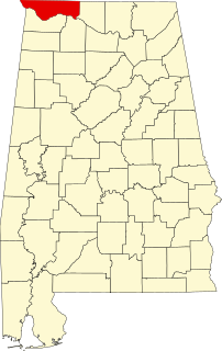
This is a list of the National Register of Historic Places listings in Lauderdale County, Alabama.

National Register of Historic Places listings in the Bronx

List of Registered Historic Places in Bronx County, New York :

National Register of Historic Places listings in Staten Island

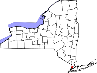
List of the National Register of Historic Places listings in Richmond County, New York.

National Register of Historic Places listings in Scott County, Iowa

This is intended to be a complete list of the properties and districts on the National Register of Historic Places in Scott County, Iowa, United States. Latitude and longitude coordinates are provided for many National Register properties and districts; these locations may be seen together in a map.

National Register of Historic Places listings in Erie County, Ohio

This is a list of the National Register of Historic Places listings in Erie County, Ohio.

National Register of Historic Places listings in Hillsborough County, Florida

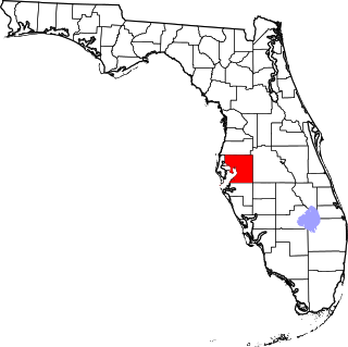
This is a list of the National Register of Historic Places listings in Hillsborough County, Florida.

National Register of Historic Places listings in Kent County, Rhode Island

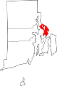
This is a list of the National Register of Historic Places listings in Kent County, Rhode Island.

National Register of Historic Places listings in Newport County, Rhode Island

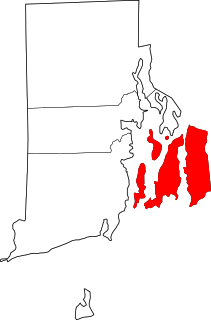
This is a list of the National Register of Historic Places listings in Newport County, Rhode Island.

National Register of Historic Places listings in Providence County, Rhode Island

This is a list of the National Register of Historic Places listings in Providence County, Rhode Island.

National Register of Historic Places listings in Washington County, Rhode Island

This is a list of the National Register of Historic Places listings in Washington County, Rhode Island.

National Register of Historic Places listings in Providence, Rhode Island

This is a list of the National Register of Historic Places listings in Providence, Rhode Island.

National Register of Historic Places listings in Pawtucket, Rhode Island

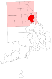
This is a list of the National Register of Historic Places listings in Pawtucket, Rhode Island.

This is intended to be a complete list of historic properties and districts listed on the National Register of Historic Places located on islands other than Manhattan Island but still in New York County, New York. For all properties and districts in the borough of Manhattan, see National Register of Historic Places listings in New York County, New York. The locations of National Register properties and districts may be seen in an online map by clicking on "Map of all coordinates".

National Register of Historic Places listings in Bristol, Virginia

This is a list of the National Register of Historic Places listings in Bristol, Virginia.

National Register of Historic Places listings in Washington County, Virginia

This is a list of the National Register of Historic Places listings in Washington County, Virginia.

National Register of Historic Places listings in Charles City County, Virginia

This is a list of the National Register of Historic Places listings in Charles City County, Virginia.

National Register of Historic Places listings in Bristol Bay Borough, Alaska

This is a list of the National Register of Historic Places listings in Bristol Bay Borough, Alaska.

National Register of Historic Places listings in Clinton County, Iowa

This is a list of the National Register of Historic Places listings in Clinton County, Iowa.

National Register of Historic Places listings in Rock Island County, Illinois

This is a list of the National Register of Historic Places listings in Rock Island County, Illinois.

This is a list of the National Register of Historic Places listings in Sullivan County, Tennessee.

References

  1. The latitude and longitude information provided in this table was derived originally from the National Register Information System, which has been found to be fairly accurate for about 99% of listings. Some locations in this table may have been corrected to current GPS standards.
  2. National Park Service, United States Department of the Interior, "National Register of Historic Places: Weekly List Actions", retrieved July 1, 2022.
  3. Numbers represent an alphabetical ordering by significant words. Various colorings, defined here, differentiate National Historic Landmarks and historic districts from other NRHP buildings, structures, sites or objects.
  4. "National Register Information System". National Register of Historic Places . National Park Service. March 13, 2009.
  5. The eight-digit number below each date is the number assigned to each location in the National Register Information System database, which can be viewed by clicking the number.
Map all coordinates using: OpenStreetMap  
Download coordinates as: KML