
Bristol is a town in Bristol County, Rhode Island, US, as well as the historic county seat. It is a deep water seaport named after Bristol, England.

The Mount Hope Bridge is a two-lane suspension bridge spanning the Mount Hope Bay in eastern Rhode Island at one of the narrowest gaps in Narragansett Bay. The bridge connects the Rhode Island towns of Portsmouth and Bristol and is part of Route 114. Its towers are 285 feet (87 m) tall, the length of the main span is 1,200 feet (370 m), and it offers 135 feet (41 m) of clearance over high water. The total length of the bridge is 6,130 feet (1,870 m).

Saunderstown is a small village and historic district in the towns of Narragansett and North Kingstown in Washington County, Rhode Island, United States. Saunderstown has its own post office with the ZIP Code of 02874, which also includes a small part of South Kingstown. Its population is 6,245.
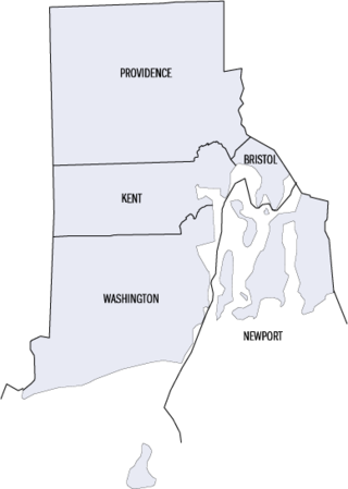
This is a list of properties and districts listed on the National Register of Historic Places in Rhode Island. As of May 29, 2015, there are more than 750 listed sites in Rhode Island. All 5 of the counties in Rhode Island have listings on the National Register.

Russell Warren (1783–1860) was an American architect, best known for his work in the Greek Revival style. He practiced in Bristol and Providence.

Colt State Park is a public recreation area that occupies 464 acres (188 ha) on Poppasquash Neck in the town of Bristol, Rhode Island, once owned by industrialist Samuel P. Colt, nephew of firearms manufacturer Samuel Colt. The park is a major component of the Poppasquash Farms Historic District, listed on the National Register of Historic Places, and is a stop on the East Bay Bike Path. The park includes trails, picnic groves, boat ramps, an observation tower, and an open air Chapel-by-the-Sea.

This is a list of the National Register of Historic Places listings in Bristol County, Rhode Island.

Mount Hope Farm is a historic estate on Metacom Avenue in Bristol, Rhode Island, United States.
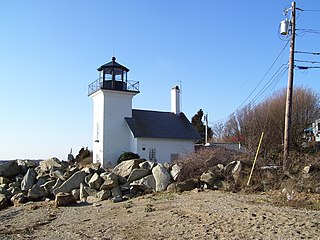
Bristol Ferry Light is a historic lighthouse in Bristol, Rhode Island, United States. It is located on the shores of Narragansett Bay at Bristol Point, the northern land point of Mount Hope Bay at the base of the Mount Hope Bridge.

Juniper Hill Cemetery is a historic cemetery at 24 Sherry Avenue in Bristol, Rhode Island founded by George R.Usher, James D'Wolf Perry, Byron Diman, Ambrose E. Burnside, James H. West, Charles H. R. Doringle, and Lemanuel W. Briggs. The original 22 acres (89,000 m2) were purchased from the descendants of Levi DeWolf, a local farmer and slave hauler, in 1855, and the cemetery corporation that owns it was chartered in January 1856. It is a fine example of the mid-19th century rural cemetery movement, with winding lanes and paths. The landscape was designed by Niles Bierragaard Schubarth, who had done similar work at other Rhode Island cemeteries. Its main entry is a massive stone gate built in 1876, and there is a gate house just inside, designed by Clifton A. Hall and constructed from granite quarried on site.

Benjamin Church House is a Colonial Revival house at 1014 Hope Street in Bristol, Rhode Island, U.S.A. It opened in 1909 as the "Benjamin Church Home for Aged Men" as stipulated by Benjamin Church's will. Beginning in 1934, during the Great Depression, it admitted women. The house was closed in 1968 and became a National Register of Historic Places listing in 1971. The non-profit Benjamin Church Senior Center was incorporated in June 1972 and opened on September 1, 1972. It continues to operate as a senior center.

The Bristol Waterfront Historic District is a historic district encompassing the original heart of Bristol, Rhode Island, which was laid out in 1680 by the town's original proprietors. It stretches from Bristol Harbor to the east side of Wood St., as far north as Washington Street, and south to Walker Cove. The district's principal areas of importance are the waterfront area on the west side, and the Town Common, part of the original layout, which forms the civic heart of the town. It is one of the few planned communities in the state, and the only one of such great age. The district features residential, civic, and commercial architecture encompassing most of its more than three centuries of existence. Its 19th-century architecture is particularly strong in examples of the work of native son Russell Warren.

The Warren Waterfront Historic District encompasses the center of Warren, Rhode Island. It is bounded on the west by the Warren River, on the north roughly by Belcher Cove, on the east roughly by Federal and Main Streets, and on the south by Campbell Street. This area is a densely built residential, commercial, and civic area that has been the center of Warren since the mid-18th century. The town prospered in the 19th century, first as a whaling and shipbuilding center and later with industrial development. The district includes the town's major civic buildings, as well as a wide variety of housing in 19th century revival and Victorian styles. It was listed on the National Register of Historic Places in 1974, and enlarged in 2003.

The Forge Road Historic District is a historic district on Forge Road from Ives Road to the Potowomut River in Warwick, Rhode Island. Most of the district's nearly 200 acres (81 ha) are taken up by the Forge Farm, which lies south of Forge Road, is one of the oldest farms in Rhode Island, and was the birthplace of American Revolutionary War general Nathanael Greene. A memorial to Greene stands near the bridge crossing the Potowomut River. Opposite the farm on Forge Road stand four houses, all of which date to the late 18th to mid-19th century.

The Tucker Farm Historic District is a historic district in Dartmouth, Massachusetts. It encompasses a farm property which has been worked since the 17th century, and several houses, one of which may have a portion dating to the ownership of Henry Tucker, the land's first English settler. It also includes a remnant of what was once a major Native trail and public right of way connecting Plymouth, Massachusetts, and Newport, Rhode Island.

The Edgewood Historic District–Arnold Farm Plat is a residential historic district in the Edgewood neighborhood of eastern Cranston, Rhode Island. It is bounded on the north by Albert Avenue, on the east by Narragansett Bay, on the south by Columbia Avenue, and on the west by Broad Street. The district was primarily built out as a streetcar suburb of Providence between 1890 and 1930, and feature styles from Queen Anne and Colonial Revival to Dutch Colonials and two- and three-decker multiunit houses. Prior to its development, the area had been farmed by several generations of the Arnold family.

The Allen–West House is an historic house at 153 George Street in Barrington, Rhode Island. The main block of the two story timber-frame house was built c. 1763 by Joseph Allen, a housewright. It is one of the older houses in Barrington, hearkening to the days when it was still part of Swansea, Massachusetts, and is a well-preserved rare example of a vernacular square house plan. The house stands amid grounds that were farmed from the 17th to the 20th centuries by the owners of this house, who included members of the Allen family until the mid-19th century, and the Wests until the mid-20th. The house has had two major additions: a kitchen ell added to the east in the 19th century and extended in the 1950s, and a c. 1920s single-story enclosed porch on the west side.
This is a list of Registered Historic Places in Barrington, Rhode Island, which has been transferred from and is an integral part of National Register of Historic Places listings in Bristol County, Rhode Island
List of Registered Historic Places in Bristol, Rhode Island, which has been transferred from and is an integral part of National Register of Historic Places listings in Bristol County, Rhode Island
List of Registered Historic Places in Warren, Rhode Island, which has been transferred from and is an integral part of National Register of Historic Places listings in Bristol County, Rhode Island


