Related Research Articles

Himachal Pradesh is a state in the northern part of India. Situated in the Western Himalayas, it is one of the thirteen mountain states and is characterised by an extreme landscape featuring several peaks and extensive river systems. Himachal Pradesh is the northernmost state of India and shares borders with the union territories of Jammu and Kashmir and Ladakh to the north, and the states of Punjab to the west, Haryana to the southwest, Uttarakhand to the southeast and a very narrow border with Uttar Pradesh to the south. The state also shares an international border to the east with the Tibet Autonomous Region in China. Himachal Pradesh is also known as Dev Bhoomi or Dev Bhumi, meaning 'Land of Gods' and Veer Bhoomi which means 'Land of the Brave'.

Virbhadra Singh was an Indian politician who served 6 terms and 21 years as the 4th Chief Minister of Himachal Pradesh. A leader of the Indian National Congress party, he was elected 9 times as a Member of Legislative Assembly to the Himachal Pradesh Vidhan Sabha and 5 times as Member of Parliament to the Lok Sabha. Virbhadra Singh was popularly known by the honorific Raja Sahib. Singh holds the distinction of being the longest serving Chief Minister of Himachal Pradesh, holding the office from 1983 to 1990, from 1993 to 1998, from 2003 to 2007 and finally from 2012 to 2017, when he was succeeded by the BJP's Jai Ram Thakur. He was elected to the Lok Sabha in 1962, 1967, 1971, 1980 and 2009. Singh served as a Union Minister in the governments of Indira Gandhi and Manmohan Singh. At the time of his demise, he was serving as an MLA from Arki constituency.

Bushahr, also spelt as 'Bashahr' and 'Bussahir' or 'Bushair' was a Rajput princely state in India during the British Raj. It was located in the hilly western Himalaya promontory bordering Tibet.

The Punjab Province was a province of British India. Most of the Punjab region was annexed by the British East India Company on 29 March 1849; it was one of the last areas of the Indian subcontinent to fall under British control. In 1858, the Punjab, along with the rest of British India, came under the rule of the British Crown. It had a land area of 358,355 square kilometers.
The Hill States of India were princely states lying in the northern border regions of the British Indian Empire.

Bilaspur State or Kahlur State, sometimes Kahloor Riyasat, was a kingdom (697–1849) and later princely state (1849–1948) in the Punjab Province ruled by a separate branch of Chandravanshi Chandel rajput dynasty. Raja Bir Chand 697–730 was the founder of the state but it was named Kahlur only after the Construction of Kahlur Fort by Raja Kahal Chand around 890–930CE and Raja Anand Chand the 44th Raja was the last ruler.

East Punjab was a province of India from 1947 until 1950. It consisted parts of the Punjab province that remained in India following the partition of the province between the new dominions of Pakistan and the Indian Union by the Radcliffe Commission in 1947. The mostly Muslim western parts of the old Punjab became Pakistan's West Punjab, later renamed as Punjab Province, while the mostly Hindu and Sikh eastern parts remained with India.
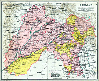
The Punjab States Agency was an agency of the British Raj. The agency was created in 1921, on the model of the Central India Agency and Rajputana Agency, and dealt with forty princely states in northwest India formerly dealt with by the Province of Punjab.

The Kangra fort is a historic fort located in the Kangra district of the Himachal Pradesh state, India. This fort is also known as 'Nagarkot' and 'Kot Kangra'. This fort stands on a hillock between two rivers, among the foothills of the Dhauladhar range. This fort is the largest in the Indian Himalayas, and is under the protection of the Archeological Survey of India.

Chamba is a town in the Chamba district in the Indian state of Himachal Pradesh. According to the 2001 Indian census, Chamba has a population of 20,312 people. Located at an altitude of 1,006 metres (3,301 ft) above mean sea level, the town is situated on the banks of the Ravi River, at its confluence with the Sal River.

Himachal Pradesh was established in 1948 as a Chief Commissioner's Province within the Union of India. The province comprised the hill districts around Shimla and southern hill areas of the former Punjab region. Himachal became a part C state on 1951 with the implementation of the Constitution of India. Himachal Pradesh became a Union Territory on 1 November 1956. On 18 December 1970 the State of Himachal Pradesh Act was passed by Parliament and the new state came into being on 25 January 1971. Thus Himachal emerged as the eighteenth state of the Indian Union.
Prior to the arrival of the Mughals in the Indian subcontinent, the first instance of Islamic conquest of the region was during the 10th century when Mahmud Ghaznavi conquered Kangra. After the entry of the Mughals into the subcontinent, the region fell to Mughal authority as well. Later, due to internal conflicts within the Mughal dynasty the rulers of the hill provinces took complete advantage. Kangra regained its independence under Maharaja Sansar Chand who ruled for nearly 50 years. He was one of the most powerful administrators of the region. After he took the formal possession of Kangra fort, Maharaja Sansar Chand began to expand his territory. The states of Chamba, Suket, Mandi, and, Guler, Jaswan, Siba and Datarpur came under the direct control of Maharaja Sansar Chand.
The hill states in India also participated in the freedom struggle (1914–1947) against the British colonial rule.

Mandi is a major city and a municipal corporation in Mandi District in the Indian state of Himachal Pradesh. It is situated 145 kilometres (90 mi) north of state capital, Shimla in the north-west Himalayas at an average altitude of 880 m (2,890 ft) Mandi is connected to the Pathankot through National Highway 20 and to Manali and Chandigarh through National Highway 21. Mandi is approximately 184.6 km (114.7 mi) from Chandigarh, the nearest major city, and 440.9 km (274.0 mi) from New Delhi, the national capital. In the 2011 Indian census, Mandi city had a population of 26,422. Mandi district is currently the 4th largest economy in the state. Mandi has the second highest sex ratio of 1013 females per thousand males, in the state.

Baragaon is a village in Kumarsain subdivision of Shimla district in the Indian state of Himachal Pradesh.
The Himachal Pradesh Police is the law enforcement agency for the state of Himachal Pradesh in India. It has one state headquarters at Shimla and 12 district headquarters in the state.

Mandi State was a native state within the Punjab, later the Punjab States Agency, with the town of Mandi as its capital. The state of Mandi, which included two towns and 3,625 villages, was part of the States of the Punjab Hills. It was located in the Himalayan range, bordering to the west, north, and east on the British Punjabi district of Kangra; to the south, on Suket; and to the southwest, on Bilaspur. As of 1941, population of Mandi State was 232,598 and area of the state was 1,139 square kilometres (440 sq mi).

Suket State was one of the Princely states of India during the period of the British Raj. The capital of the state was Pangna. Its last ruler signed the accession to the Indian Union on 15 April 1948. Formerly it belonged to the States of the Punjab Hills and currently, it is part of the Indian state of Himachal Pradesh. The present-day Mandi district was formed with the merger of the two princely states of Mandi and Suket.
Siba State, was a small independent Indian hill state in the Lower Himalayas. It was centered on the town of Dadasiba, Pragpur tehsil, Kangra district, in modern-day Himachal Pradesh. The state was founded in 1450. In 1849 the territory of Datarpur was added to Siba Jagir and annexed by the British Raj as 'Dada-Siba'.
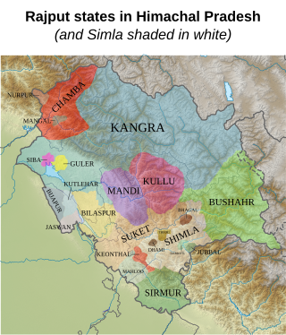
The Rajputs in Himachal Pradesh are members of the Rajput community living in the North Indian Himalayan state of Himachal Pradesh. They ruled a majority of kingdoms of the region and even dominate in Himachal Pradesh politics. The kingdoms of the Hill States of India were mostly in the present day state of Himachal Pradesh, and mostly had Rajput rulers. All of the Chief Ministers who served Himachal Pradesh except for Shanta Kumar belong to the Rajput caste. The Rajputs of Himachal Pradesh fought battles with Tughlaq, Mughal, and Sikh forces, most notable being the Battle of Bhangani, when the Hill States made an alliance against the Sikhs. While some Rajput kingdoms and clans have a long history in Himachal Pradesh, others were established due to the Rajput migrations to the hill regions mostly due to the Islamic invasions.
References
- 1 2 "History of Himachal". Cultural Dep. of Himachal. Archived from the original on 23 August 2006. Retrieved 26 October 2006.