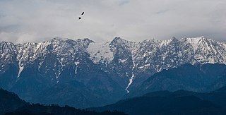
Himachal Pradesh is a state in the northern part of India. Situated in the Western Himalayas, it is one of the eleven mountain states and is characterized by an extreme landscape featuring several peaks and extensive river systems. Himachal Pradesh is the northernmost state of India and shares borders with the union territories of Jammu and Kashmir and Ladakh to the north, and the states of Punjab to the west, Haryana to the southwest, Uttarakhand to the southeast and a very narrow border with Uttar Pradesh to the South. The state also shares an international border to the east with the Tibet Autonomous Region in China. Himachal Pradesh is also known as 'Dev Bhoomi' or 'Land of Gods and Goddess' and 'Veer Bhoomi' which means 'Land of Braves'.

The Middle kingdoms of India were the political entities in India from 200 BC to 1200 AD. The period begins after the decline of the Maurya Empire and the corresponding rise of the Satavahana dynasty, starting with Simuka, from 230 BC. The "Middle" period lasted for about 1,500 years and ended in 1200 AD, with the rise of the Delhi Sultanate, founded in 1206, and the end of the Later Cholas.
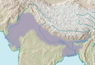
The Indo-Gangetic Plain, also known as the North Indian River Plain, is a 0.70-million km2 (172-million-acre) fertile plain encompassing northern regions of the Indian subcontinent, including most of northern and eastern India, the eastern parts of Pakistan, virtually all of Bangladesh and southern plains of Nepal. The region is named after the Indus and the Ganges rivers and encompasses a number of large urban areas. The plain is bound on the north by the Himalayas, which feed its numerous rivers and are the source of the fertile alluvium deposited across the region by the two river systems. The southern edge of the plain is marked by the Chota Nagpur Plateau. On the west rises the Iranian Plateau. Many developed cities like Kolkata, Delhi, Karachi and Dacca are located in the Indo-Gangetic Plain

The History of the Punjab refers to the history of the Punjab region, a geopolitical, cultural, and historical region in South Asia, comprising areas of eastern Pakistan and northern India. Ancient Punjab was the primary geographical extent of the Indus Valley Civilisation, which was notable for advanced technologies and amenities that the people of the region had used. During the Vedic period, Punjab was referred to as Sapta Sindhu, or the Land of Seven Rivers. Punjab was historically a Hindu region during this period. Intermittent wars between various kingdoms were characteristic of the time, except when they temporarily unified under centralised Indian Empires or invading powers.

Garhwal is one of the two administrative divisions of the Indian state of Uttarakhand. Lying in the Himalayas, it is bounded on the north by Tibet, on the east by Kumaon region, on the south by Uttar Pradesh state, and on the northwest by Himachal Pradesh state. It includes the districts of Chamoli, Dehradun, Haridwar, Pauri Garhwal, Rudraprayag, Tehri Garhwal, and Uttarkashi. The people of Garhwal are known as Garhwali and speak the Garhwali language. The administrative center for Garhwal division is the town of Pauri. The Divisional Commissioner is the administrative head of the Division, and is a senior Indian Administrative Service officer. As the administrative head of the division, the Commissioner is overall incharge of the 7 districts in the Garhwal region of Uttarakhand, and is aided in his duties by an Additional Commissioner and the District Magistrates. Vinod Sharma is currently the Divisional Commissioner of the Garhwal Division.

Una is a district in the Indian state of Himachal Pradesh. Una shares its border with the Hoshiarpur and Rupnagar districts of Punjab and Kangra, Hamirpur and Bilaspur district of Himachal Pradesh. The terrain is generally semi-hilly with low hills.

Bilaspur is a district of Himachal Pradesh, India. Its headquarters are in the town of Bilaspur. The district has an area of 1,167 km2, and a population of 381,956. As of 2011 it is the third least populous district of Himachal Pradesh, after Lahul and Spiti and Kinnaur.

Bhakra Dam is a concrete gravity dam on the Sutlej River in Bilaspur, Himachal Pradesh in northern India. The dam forms the Gobind Sagar reservoir.
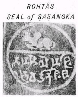
Shashanka was the first independent king of a unified polity in the Bengal region, called the Gauda Kingdom and is a major figure in Bengali history. He reigned in the 7th century, some historians place his rule between circa 600 CE and 636/7 CE, whereas other sources place his reign between 590 and 625 CE.

Khasas were an ancient tribe mentioned in the various historical Indian inscriptions and ancient Indian and Tibetan literatures. They were reported to have lived around Gandhara, Trigarta and Madra Kingdom in the northern Indian subcontinent.
Kullu is a municipal council town that serves as the administrative headquarters of the Kullu district of the Indian state of Himachal Pradesh. It is located on the banks of the Beas River in the Kullu Valley about 10 kilometres (6.2 mi) north of the airport at Bhuntar.
Katoch is a Chandravanshi Rajput clan. Their traditional area of residence was in the Trigarta Kingdom mentioned in the epic Mahabharata, based at Jalandhar and at Kangra Fort in the Indian state of Himachal Pradesh.

Doaba also known as Bist Doab, is the region of Punjab, India that lies between the Beas River and the Sutlej River. People of this region are given the demonym "Doabia". The dialect of Punjabi spoken in Doaba is called "Doabi". The term "Doaba" or "Doab" is derived from Persian "دو آب" meaning "land of two rivers". The river Sutlej separates Doaba from the Malwa region to its south and the river Beas separates Doaba from the Majha region to its north.

The state of Himachal Pradesh is spread over an area 55,673 km2 (21,495 sq mi) and is bordered by Jammu and Kashmir and Ladakh on the north, Punjab on the southwest, Haryana on the south, Uttarakhand on the southeast, a small border with Uttar Pradesh in the south, and Tibet on the east. Entire Himachal Pradesh lies in the mountainous Himalaya region, rich in natural resources.
Himachal Pradesh is located in north India and became 18th state of India.
Prior to the arrival of the Mughals in the Indian subcontinent, the first instance of Islamic conquest of the region was during the 10th century when Mahmud Ghaznavi conquered Kangra. After the entry of the Mughals into the subcontinent, the region fell to Mughal authority as well. Later, due to internal conflicts within the Mughal dynasty the rulers of the hill provinces took complete advantage. Kangra regained its independence under Maharaja Sansar Chand who ruled for nearly 50 years. He was one of the most powerful administrators of the region. After he took the formal possession of Kangra fort, Maharaja Sansar Chand began to expand his territory. The states of Chamba, Suket, Mandi, and, Guler, Jaswan, Siba and Datarpur came under the direct control of Maharaja Sansar Chand.

The history of the Indian state Madhya Pradesh is divided into three periods - the ancient period, the medieval period and the modern period.
The Kanet is a caste found in the state of Himachal Pradesh in North India. They are generally regarded as a Thakur (noble) caste, even though they have sometimes been classified otherwise.

Mandi is a major town and a municipal corporation in Mandi District in the Indian state of Himachal Pradesh.
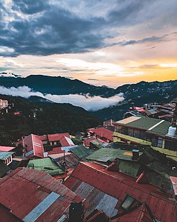
Tourism in Himachal Pradesh relates to tourism in the Indian state of Himachal Pradesh. This is popularly renowned for its Himalayan landscapes and popular hill-stations. Many outdoor activities such as rock climbing, mountain biking, paragliding, ice-skating, trekking, rafting, and heli-skiing are popular tourist attractions in Himachal Pradesh.