Broadway (Winnipeg)

Last updated
Broadway

Manitoba Highway 1.svg

Provincial Trunk Highway 1
Trans-Canada Highway
Broadway (Winnipeg)
Broadway highlighted in red
Maintained by City of Winnipeg
Length2.3 km (1.4 mi) [1]
Component
highways
PTH 1 (Trans-Canada Highway)
West end Route 85 (Portage Ave)
Major
junctions
East end Route 52 (Main St)

Broadway is a street in the city of Winnipeg, Manitoba, Canada. It is one of the city's oldest and most historic routes and forms the Trans-Canada Highway route through the city's downtown.

Contents

The street is located between Main Street and Osborne Street, bookended by the Union Station to the east and the Manitoba Legislative Building to the west. Broadway also functions as an unofficial boundary between the commercial and residential areas in the southern part of downtown. [2] [3]

Route description

Broadway begins at Main Street (Route 52), opposite Union Station, near the confluence of the Red and Assiniboine Rivers. It travels 2.2 kilometres (1.4 mi) west before merging into westbound Portage Avenue (Route 85). The street is divided into two distinct sections to the east and west, which are separated by Osborne Street (Route 62).

To the east is the downtown portion of Broadway, which is a picturesque street with a wide, park-like boulevard and elm canopy. The street passes by several of Winnipeg's oldest buildings, including the Manitoba Legislative Building, Fort Garry Hotel, Provincial Law Courts Building, and many other heritage buildings. [3] Because of its position in the southern part of downtown, the area also functions as a demarcation between commercial development to the north and a residential enclave south to the Assiniboine River. [2] [3]

West of Osborne Street, Broadway enters a residential area known as West Broadway and becomes a four-lane street with no median strip. Osborne Stadium and Shea's Amphitheatre, among the city's earliest sports facilities, were once located in this district near Broadway. [4] [5]

The Trans-Canada Highway (PTH 1) follows the full length of Broadway from Main Street (south) to Portage Avenue (west).

Landmarks

History

The origin of Broadway predates the city of Winnipeg, beginning as an exclusive residential district known as the Hudson's Bay Reserve. [2]

The large block of land near Upper Fort Garry was originally granted to the Hudson's Bay Company (HBC) by the Government of Canada. [2] Broadway was thereby developed as the main east–west thoroughfare through HBC's land reserve around Upper Fort Garry and connected with the Fort Ellice Trail leading to Edmonton, now known as the Yellowhead Highway. [6] Most of the fort has since been demolished and the only surviving gate has been incorporated into Upper Fort Garry Provincial Park, located at the southwest corner of Broadway and Main Street. [7] [8]

As early as 1873, cottages and other small structures began to appear. By the 1880s, the area became a desirable residential neighborhood for some of Winnipeg's wealthiest families. However, as the early 20th century saw the emergence of several other wealthy residential areas such as Armstrong's Point, Fort Rouge, Crescentwood, Wolseley, and River Heights, Broadway lost many of its elite residents. [2]

With the drastic demographic change, throughout the following decades, many of the area's homes were either subdivided into rooming houses or torn down completely. This would lead to the development of Broadway as the predominantly commercial district it is known as today, signaled by a building boom in the late 1950s to early 1970s. Among others, the locally based but British-funded development firm Metropolitan Estate and Property Corporation (MEPC) was one of the earliest groups dedicated to making Broadway a viable business district, or the "Wall Street of the West". Architecture that arose in the post-1945 development of the area was mostly modernist, designed by various notable firms in Winnipeg. [2]

Prior to the construction of Union Station, Broadway extended to the Red River and connected with St. Boniface via the Broadway Bridge. Today, a pedestrian corridor known as the Broadway Promenade maintains the connection between Broadway and Provencher Boulevard in St. Boniface. [9] [10]

Major intersections

From east to west:

Locationkm [1] miDestinationsNotes
Downtown 0.00.0Winnipeg city route 52.svgManitoba Highway 1.svg Main Street (Route 52) / PTH 1 (TCH) east Union Station PTH 1 branches south onto Main Street (Route 52)
0.10.062Fort StreetOne-way northbound
0.20.12Garry Street Fort Garry Hotel One-way southbound
0.30.19Winnipeg city route 42.svg Smith Street (Route 42 north) Burton Cummings Theatre One-way northbound
0.40.25Winnipeg city route 42.svg Donald Street (Route 42 south)One-way southbound
0.50.31Hargave Street Canada Life Centre, Cityplace One-way northbound
0.60.37Carlton Street True North Square One-way southbound
0.70.43Edmonton Street Convention Centre, Portage Place One-way northbound
0.80.50Kennedy StreetOne-way southbound
1.00.62Memorial Boulevard Manitoba Legislative Building
1.20.75Winnipeg city route 62.svg Osborne Street (Route 62) Winnipeg Art Gallery, University of Winnipeg
West End 1.81.1Winnipeg city route 70.svg Sherbrook Street (Route 70 north)One-way, northbound
2.01.2Winnipeg city route 70.svg Maryland Street (Route 70 south)One-way, southbound
2.31.4Yellowhead Blank.svgWinnipeg city route 85.svgManitoba Highway 1.svg Portage Avenue (Route 85) / PTH 1 (TCH) westPTH 1 branches west onto Portage Avenue (Route 85)
1.000 mi = 1.609 km; 1.000 km = 0.621 mi

See also

Related Research Articles

<span class="mw-page-title-main">Fort Garry</span> Historic trading post in present-day downtown Winnipeg, Manitoba, Canada

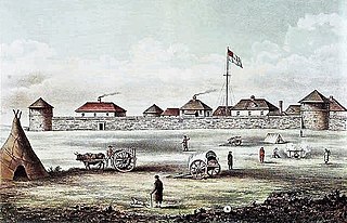
Fort Garry, also known as Upper Fort Garry, was a Hudson's Bay Company trading post at the confluence of the Red and Assiniboine rivers in what is now downtown Winnipeg.

<span class="mw-page-title-main">Winnipeg South Centre</span> Federal electoral district in Manitoba, Canada

Winnipeg South Centre is a federal electoral district in Manitoba, Canada, that has been represented in the House of Commons of Canada from 1925 to 1979 and since 1988.

Provincial Trunk Highway 1 is Manitoba's section of the Trans-Canada Highway. It is a heavily used, 4-lane divided highway, with the exception of a short 18 km section in the southeastern corner of the province. It is the main link between southern Manitoba's largest cities, and also serves as the province's main transportation link to the neighbouring provinces of Saskatchewan and Ontario. The highway is the only major east-west divided highway in Manitoba, and carries a large majority of east-west traffic within and through the province. It has full freeway status sections at Portage la Prairie and Winnipeg. The total distance of the Trans-Canada Highway in Manitoba is approximately 490 km (300 mi).

<span class="mw-page-title-main">Fort Rouge, Winnipeg</span>

Fort Rouge is a district of Winnipeg, Manitoba, in Canada. Located in the south-central part of the city, it is bounded on the north by the Assiniboine River, on the east and south by the Red River, and on the west by Stafford Street and Pembina Highway.

Metropolitan Corporation of Greater Winnipeg was a governing body that served as part of the leadership for the metropolitan area of Winnipeg. It was established by Premier Douglas Campbell after he was given a commission to do so by the Greater Winnipeg Investigating Commission. It was dissolved when its component municipalities were amalgamated into one "unicity" in 1972. Winnipeg is a city in Manitoba, Canada.

<span class="mw-page-title-main">Osborne Village</span> Neighbourhood in Winnipeg, Manitoba, Canada

Osborne Village is a neighbourhood of Winnipeg, Manitoba. The area is bordered by the Assiniboine River on the north and west, Harkness Station on the east, and the Osborne Underpass on the south.

<span class="mw-page-title-main">Downtown Winnipeg</span> Neighbourhood in Winnipeg, Manitoba, Canada

Downtown Winnipeg is an area of Winnipeg located near the confluence of the Red and Assiniboine rivers. It is the oldest urban area in Winnipeg, and is home to the city's commercial core, city hall, the seat of Manitoba's provincial government, and a number of major attractions and institutions.

<span class="mw-page-title-main">The Forks, Winnipeg</span> Historic Meeting Place in Manitoba, Canada

The Forks is a historic site, meeting place, and green space in downtown Winnipeg located at the confluence of the Red River and the Assiniboine River.

<span class="mw-page-title-main">West End, Winnipeg</span> Urban area in Manitoba, Canada

The West End is a mostly residential area of Downtown Winnipeg, Manitoba, Canada. It includes the neighbourhoods of Armstrong's Point, Colony, Daniel McIntyre, Minto, Sargent Park, Spence, St. Matthews, West Broadway, and Wolseley.

<span class="mw-page-title-main">St. Norbert, Winnipeg</span> Suburb of Winnipeg

St. Norbert is a bilingual neighbourhood and the southernmost suburb of Winnipeg, Manitoba, Canada. While outside the Perimeter Highway, it is still part of the city. As of the 2016 Census, the population of St. Norbert is 5,850.

<span class="mw-page-title-main">Geography and climate of Winnipeg</span>

Winnipeg lies at the bottom of the Red River Valley, a low-lying flood plain with an extremely flat topography. This valley was formed by the ancient glacial Lake Agassiz which has rich deposits of black soil. Winnipeg is on the eastern edge of the Canadian Prairies in Western Canada; it is known as the 'Gateway to the West'. It is relatively close to many large Canadian Shield lakes and parks, as well as Lake Winnipeg. Winnipeg is bordered by tallgrass prairie to the west and south and the aspen parkland to the northeast.

<span class="mw-page-title-main">Winnipeg Route 42</span> Bridge

Route 42 is a major arterial road located in Winnipeg, Manitoba.

<span class="mw-page-title-main">Winnipeg Route 52</span>

Route 52 is a major north-south arterial route in Winnipeg, Manitoba, Canada. It comprises all of Main Street, Queen Elizabeth Way, and St. Mary's Road.

<span class="mw-page-title-main">Winnipeg Route 62</span>

Route 62 is a major north–south arterial route in Winnipeg, Manitoba that has eight different street names.

<span class="mw-page-title-main">Winnipeg Route 57</span>

Route 57 is a major road located in Winnipeg, Manitoba. It connects the suburbs of St. James and St. Boniface with the West End and the downtown core.

<span class="mw-page-title-main">Winnipeg Route 105</span>

Route 105 is a major east-west arterial route in the city of Winnipeg. It runs through the suburbs of Fort Rouge, River Heights, Tuxedo, and Charleswood. It is the eastern extension of Provincial Road 241, which runs westward to the communities of Headingley and Lido Plage. Within the city boundaries it connects the residential and light industrial areas west-southwest of downtown with the Pembina Highway and downtown.

<span class="mw-page-title-main">History of Winnipeg</span>

The history of Winnipeg comprises its initial population of Aboriginal peoples through its settlement by Europeans to the present day. The first forts were built on the future site of Winnipeg in the 1700s, followed by the Selkirk Settlement in 1812. Winnipeg was incorporated as a city in 1873 and experienced dramatic growth in the late 19th and early 20th centuries. Following the end of World War I, the city's importance as a commercial centre in Western Canada began to wane. Winnipeg and its suburbs experienced significant population growth after 1945, and the current City of Winnipeg was created by the unicity amalgamation in 1972.

Fur trading on the Assiniboine River and the general area west of Lake Winnipeg, in what is now Manitoba, Canada, began as early as 1731.

Most of the following timelines for Manitoba's history is taken from either the Manitoba Historical Society, or from the Heritage Manitoba and the Gimli Municipal Heritage Advisory Committee, as adapted from a three-volume history of Manitoba published in 1993 titled Manitoba: 125.

References

  1. 1 2 Google (August 10, 2017). "Broadway in Winnipeg" (Map). Google Maps . Google. Retrieved August 10, 2017.
  2. 1 2 3 4 5 6 "Winnipeg Architecture: Broadway Modern". Winnipeg Architecture Foundation. Retrieved 2022-08-07.
  3. 1 2 3 "Manitoba Legislative Building". Manitoba Historical Society. Retrieved October 30, 2014.
  4. "Lost Winnipeg: Osborne Place". Spectator Tribune. April 29, 2013. Retrieved October 30, 2014.
  5. McNeill, Murray (August 22, 2011). "Betting big on West Broadway". Winnipeg Free Press.
  6. "Upper Fort Garry". Manitoba Historical Society. Retrieved October 30, 2014.
  7. "Greater Winnipeg". heritagewinnipeg.com. Retrieved October 30, 2014.
  8. "History in Winnipeg Streets". Manitoba Historical Society. Retrieved October 30, 2014.
  9. "Broadway Promenade". Forks North Portage Corporation. Retrieved October 31, 2014.
  10. "A Path to Peace". Manitoba Historical Society. Retrieved October 31, 2014.