Broadway Bridge (Portland, Oregon)

Last updated
Broadway Bridge
BroadwayBridge.jpg
Coordinates 45°31′55″N122°40′26″W / 45.5319°N 122.6739°W / 45.5319; -122.6739
CarriesVehicles, Portland Streetcar and pedestrians
Crosses Willamette River
Locale Portland, Oregon
Maintained by Multnomah County
ID number 06757
Characteristics
Design Truss with double-leaf Rall-type bascule lift span
Total length1,742 ft (531 m)
Width70 ft (21 m)
Longest spanFixed: 297 ft (91 m)
Double-leaf bascule:
278 ft (85 m) [1]
Clearance above 13 ft (4.0 m)
Clearance below 90 ft (27 m) at center [1] :31 (when bascule span is closed)
History
Designer Ralph Modjeski
OpenedApril 22, 1913
Broadway Bridge
Location Portland, Oregon; Willamette River at river mile 11.7
Coordinates 45°31′55″N122°40′26″W / 45.531816°N 122.673898°W / 45.531816; -122.673898 Coordinates: 45°31′55″N122°40′26″W / 45.531816°N 122.673898°W / 45.531816; -122.673898
MPS Willamette River Highway Bridges of Portland, Oregon
NRHP reference No. 12000930 [2]
Added to NRHPNovember 14, 2012 [2]

The Broadway Bridge is a Rall-type bascule bridge spanning the Willamette River in Portland, Oregon, United States, built in 1913. It was Portland's first bascule bridge, and it continues to hold the distinction of being the longest span of its bascule design type in the world. [3] It was added to the National Register of Historic Places in November 2012. [2] [4]

Contents

History and description

The bridge was anticipated to be the world's longest bascule bridge and there was competition between the Strauss, Scherzer, and Rall bascule design patent holders. [5] The "Rall" was selected based on cost. [1] [6]

Ralph Modjeski designed the structure, [7] which opened on April 22, 1913, at a cost of $1.6 million. It was the world's longest double-leaf bascule bridge, of any bascule type, at the time. [1] The bridge's name derives from the street it carries, Broadway, but at the time of the bridge's construction that street name was in use only east of the river. The westside portion of what is now Broadway had been named 7th Avenue, but was renamed Broadway when the bridge opened and connected the two streets. [1]

The bridge has four vehicle lanes (two lanes in each direction) that in 2006 carried about 30,000 vehicles per day. [1] It is also a major bicycle route over the river with more than 2,000 crossings daily in 2005, [8] and has a pair of 11-foot (3.4 m) wide sidewalks. On average, the bridge's draw span is opened about 25 times a month. [5]

In 1927–28, a 2,000-foot (610 m)-long [9] viaduct was built from the bridge's west deck, extending due west above Lovejoy Street to 14th Avenue, providing access to and from the bridge that had previously been blocked by railroad yards. This viaduct was known as the Lovejoy Ramp. A shorter ramp rising from Northwest 10th Avenue at Irving Street and connecting to the easternmost portion of the new Lovejoy viaduct was built in 1927, but not opened, due to delays to the start of work on the Lovejoy viaduct's western section (west of 10th), [10] and did not open until October 1928. [11] Construction of the long viaduct section from 10th to 14th began in mid-1928, and the viaduct opened in December 1928. [12]

The bridge's bascule span open Close-up of raised bascule span of Broadway Bridge (Portland) in 2013.jpg
The bridge's bascule span open

The bridge was originally black, in common with the nearby Steel and Hawthorne spans, but Portland architect Lewis Crutcher suggested in 1961 that each have its own distinct color. [13] The Broadway Bridge was repainted "Golden Gate" red [1] [14] [15] (also known as international orange) [16] in 1963. [17]

The bridge was added to the National Register of Historic Places in November 2012. [2] [4]

Public transit use

Streetcars originally crossed the bridge from its opening in 1913 until 1940, [18] but by at least 1944, the abandoned tracks had been removed or paved over. Work to reinstall tracks began in 2010, [19] and streetcar service across the bridge resumed in 2012. [20] The Broadway Bridge was also used by trolley buses, from 1937 to 1958. [21] In addition to the Portland Streetcar's A Loop and B Loop lines, one TriMet bus route currently uses the bridge, route 17-Broadway. [22]

Modifications and repairs

Because it is such a complicated bridge there have been frequent repairs to its structure and mechanicals. In 1948, the concrete deck was replaced with steel grating. During 1982, bicycle access was improved through an $18,000 signal and sidewalk upgrade. In order to improve access and reduce energy costs, the sidewalks and lighting were replaced in 2000–2001. [23] The Lovejoy Ramp, the long viaduct to and from 14th Avenue, was removed in 1999 as part of a $12.4 million [24] reconstruction, intended to open up the site of the by-then-abandoned railroad yards for redevelopment. [25] It was rebuilt as a much shorter Lovejoy ramp, from 9th Avenue, which opened in May 2002. [24] A $28 million renovation began in February 2003. Included in this was the replacement of steel grating with a fiber-reinforced polymer composite material called DuraSpan, made by Martin Marietta Materials. [26] The renovation was completed in February 2005.

A streetcar at the west end of the bridge in 2013 Portland Streetcar car 021 at west end of Broadway Bridge.jpg
A streetcar at the west end of the bridge in 2013
Lights along the bridge Broadway Bridge south sidewalk at dusk - Portland, Oregon.jpg
Lights along the bridge

In July 2010, the bridge was closed to all traffic for two months in order to begin re-installing streetcar infrastructure, for an expansion of the Portland Streetcar system. [19] [27] Progress was sufficient to reopen two of four lanes of the bridge on September 4. [28] Streetcar-related construction continued through 2011, including installation of the overhead power equipment. The new streetcar line opened in September 2012 and was known as the CL Line (Central Loop); [20] in 2015, its name was changed to A Loop (clockwise) and B Loop (counterclockwise).

The Broadway Bridge is prominently featured in the climax of the film Untraceable (2008). [29] In the film, FBI agent Jennifer Marsh (Diane Lane) becomes stranded on the east end of the bridge after an online serial killer hacks into her car's computer. [30] The scene was filmed both on location as well as on a studio sound stage. The bridge is also a setting for the 1996 film Foxfire , its most notable appearance being in the final scene when Legs Sadovsky (Angelina Jolie) and Maddy Wirtz (Hedy Burress) decide to part ways.[ citation needed ]

Historic American Engineering Record drawings

Detailed drawings and description from the Historic American Engineering Record (HAER), a U.S. National Park Service program.

Photographs

See also

Related Research Articles

<span class="mw-page-title-main">Portland Streetcar</span> Streetcar system in Portland, Oregon

The Portland Streetcar is a streetcar system in Portland, Oregon, that opened in 2001 and serves areas surrounding downtown Portland. The 3.9-mile (6.3 km) NS Line runs from Northwest Portland to the South Waterfront via Downtown and the Pearl District. The Loop Service, which opened in September 2012 as the Central Loop, runs from Downtown to the Oregon Museum of Science and Industry via the Pearl District, the Broadway Bridge across Willamette River, the Lloyd District, and the Central Eastside Industrial District and added 3.3 miles (5.3 km) of route. In September 2015 the line was renamed as the Loop Service, with the A Loop traveling clockwise, and the B Loop traveling counterclockwise. The two-route system serves some 20,000 daily riders.

<span class="mw-page-title-main">Steel Bridge</span> Bridge in Portland, Oregon

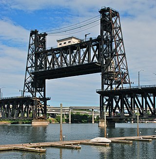
The Steel Bridge is a through truss, double-deck vertical-lift bridge across the Willamette River in Portland, Oregon, United States, opened in 1912. Its lower deck carries railroad and bicycle/pedestrian traffic, while the upper deck carries road traffic, and light rail (MAX), making the bridge one of the most multimodal in the world. It is the only double-deck bridge with independent lifts in the world and the second oldest vertical-lift bridge in North America, after the nearby Hawthorne Bridge. The bridge links the Rose Quarter and Lloyd District in the east to Old Town Chinatown neighborhood in the west.

The Pearl District is an area of Portland, Oregon, formerly occupied by warehouses, light industry and railroad classification yards and now noted for its art galleries, upscale businesses and residences. The area has been undergoing significant urban renewal since the mid-1980s when it was reclassified as mixed use from industrial, including the arrival of artists, the removal of a viaduct and construction of the Portland Streetcar. It now consists of industrial building conversion to offices, high-rise condominiums and warehouse-to-loft conversions.

<span class="mw-page-title-main">Hawthorne Bridge</span> Bridge over the Willamette River in Portland, Oregon

The Hawthorne Bridge is a truss bridge with a vertical lift that spans the Willamette River in Portland, Oregon, joining Hawthorne Boulevard and Madison Street. It is the oldest vertical-lift bridge in operation in the United States and the oldest highway bridge in Portland. It is also the busiest bicycle and transit bridge in Oregon, with over 8,000 cyclists and 800 TriMet buses daily. It was added to the National Register of Historic Places in November 2012.

<span class="mw-page-title-main">Bascule bridge</span> Moveable bridge with a counterweight which keeps the span(s) balanced during the upswing

A bascule bridge is a moveable bridge with a counterweight that continuously balances a span, or leaf, throughout its upward swing to provide clearance for boat traffic. It may be single- or double-leafed.

<span class="mw-page-title-main">Fremont Bridge (Portland, Oregon)</span> Bridge in Portland, Oregon

The Fremont Bridge is a steel tied-arch bridge over the Willamette River located in Portland, Oregon, United States. It carries Interstate 405 and US 30 traffic between downtown and North Portland where it intersects with Interstate 5. It has the longest main span of any bridge in Oregon and is the second longest tied-arch bridge in the world. The bridge was designed by Parsons, Brinckerhoff, Quade and Douglas, and built by Murphy Pacific Corporation.

<span class="mw-page-title-main">Burnside Bridge</span> Bridge in Portland, Oregon

The Burnside Bridge is a 1926-built bascule bridge that spans the Willamette River in Portland, Oregon, United States, carrying Burnside Street. It is the second bridge at the same site to carry that name. It was added to the National Register of Historic Places in November 2012.

<span class="mw-page-title-main">Morrison Bridge</span> Bridge in Oregon, U.S.

The Morrison Bridge is a bascule bridge that spans the Willamette River in Portland, Oregon. Completed in 1958, it is the third bridge at approximately the same site to carry that name. It is one of the most heavily used bridges in Portland. It was added to the National Register of Historic Places in November 2012.

<span class="mw-page-title-main">Marquam Bridge</span> Carries Interstate 5 traffic over the Willamette River in Portland, Oregon

The Marquam Bridge is a double-deck, steel-truss cantilever bridge that carries Interstate 5 traffic across the Willamette River from south of downtown Portland, Oregon, on the west side to the industrial area of inner Southeast on the east. It is the busiest bridge in Oregon, carrying 140,500 vehicles a day as of 2016. The upper deck carries northbound traffic; the lower deck carries southbound traffic. The Marquam also has on and off ramps for Interstate 405 on the south end of the bridge, while the terminus on the east bank of the river is near the interchange with Interstate 84.

<span class="mw-page-title-main">Ross Island Bridge</span> Bridge in Portland, Oregon

The Ross Island Bridge is a cantilever truss bridge that spans the Willamette River in Portland, Oregon. It carries U.S. Route 26 across the river between southwest and southeast Portland. The bridge opened in 1926 and was designed by Gustav Lindenthal and honors Oregon pioneer Sherry Ross. It is named for its proximity to Ross Island. Although it looks like a deck arch bridge, it is a cantilever deck truss bridge, a rare type in Oregon.

<span class="mw-page-title-main">Interstate Bridge</span> Highway bridge crossing the Columbia River between Portland, Oregon and Vancouver, Washington

The Interstate Bridge is a pair of nearly identical steel vertical-lift, Parker through-truss bridges that carry Interstate 5 traffic over the Columbia River between Vancouver, Washington and Portland, Oregon in the United States.

<span class="mw-page-title-main">Sellwood Bridge</span> Bridge in Portland, OR

The Sellwood Bridge is a deck arch bridge that spans the Willamette River in Portland, Oregon, in the United States. The current bridge opened in 2016 and replaced a 1925 span that had carried the same name. The original bridge was Portland's first fixed-span bridge and, being the only river crossing for miles in each direction, the busiest two-lane bridge in Oregon. The Sellwood Bridge links the Sellwood and Westmoreland neighborhoods of Portland on the east side with Oregon Route 43/Macadam Avenue on the west side. At its east end it leads to Tacoma Street. The bridge is owned and operated by Multnomah County. The original span of 1925 was a steel truss bridge, while its 2016 replacement is a deck-arch-type bridge.

<span class="mw-page-title-main">Burlington Northern Railroad Bridge 5.1</span> Railroad bridge in Portland, Oregon

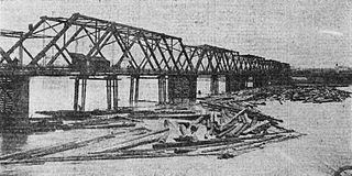
The Burlington Northern Railroad Bridge 5.1 or BNSF Railway Bridge 5.1, also known as the St. Johns Railroad Bridge or the Willamette River Railroad Bridge, is a through truss railway bridge with a vertical lift that spans the Willamette River in Portland, Oregon, United States. Built by the Spokane, Portland and Seattle Railway (SP&S) and completed in 1908, it was originally a swing-span bridge, and its swing-span section was the longest in the world at the time. However, 81 years later the main span was converted from a swing-type to a vertical-lift type, in order to widen the navigation channel. The lift span is one of the highest and longest in the world. The bridge consists of five sections, with the two sections closest to the bank on each side fixed.

<span class="mw-page-title-main">Interstate 405 (Oregon)</span> Interstate highway in Portland, Oregon, U.S.

Interstate 405 (I-405), also known as the Stadium Freeway No. 61, is a short north–south Interstate Highway in Portland, Oregon. It forms a loop that travels around the west side of Downtown Portland, between two junctions with I-5 on the Willamette River near the Marquam Bridge to the south and Fremont Bridge to the north.

<span class="mw-page-title-main">Transportation in Portland, Oregon</span> Overview of movement of goods and passengers in Portland

Like transportation in the rest of the United States, the primary mode of local transportation in Portland, Oregon is the automobile. Metro, the metropolitan area's regional government, has a regional master plan in which transit-oriented development plays a major role. This approach, part of the new urbanism, promotes mixed-use and high-density development around light rail stops and transit centers, and the investment of the metropolitan area's share of federal tax dollars into multiple modes of transportation. In the United States, this focus is atypical in an era when automobile use led many areas to neglect their core cities in favor of development along interstate highways, in suburbs, and satellite cities.

Portland is "an international pioneer in transit orientated developments."

<span class="mw-page-title-main">Vista Bridge</span> Bridge in Portland, Oregon, U.S.

The Vista Bridge is an arch bridge for vehicles and pedestrians located in Portland, Oregon, United States. It connects the areas of King's Hill and Vista Ridge which are both in the Goose Hollow neighborhood. The MAX Light Rail line and Jefferson Street/Canyon Road travel under the bridge, and Vista Avenue crosses the bridge.

<span class="mw-page-title-main">Tilikum Crossing</span> Bridge over the Willamette River, Portland, OR, USA

Tilikum Crossing, Bridge of the People is a cable-stayed bridge across the Willamette River in Portland, Oregon, United States. It was designed by TriMet, the Portland metropolitan area's regional transit authority, for its MAX Orange Line light rail passenger trains. The bridge also serves city buses and the Portland Streetcar, as well as bicycles, pedestrians, and emergency vehicles. Private cars and trucks are not permitted on the bridge. It is the first major bridge in the U.S. that was designed to allow access to transit vehicles, cyclists and pedestrians but not cars.

<i>Lovejoy Columns</i> Columns with murals in Portland, Oregon

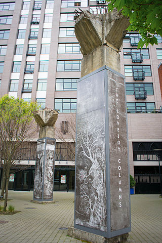
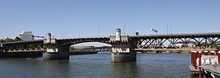
The Lovejoy Columns, located in Portland, Oregon, United States, supported the Lovejoy Ramp, a viaduct that from 1927 to 1999 carried the western approach to the Broadway Bridge over the freight tracks in what is now the Pearl District. The columns were painted by Greek immigrant Tom Stefopoulos between 1948 and 1952. In 1999, the viaduct was demolished but the columns were spared due to the efforts of the architectural group Rigga. For the next five years, attempts to restore the columns were unsuccessful and they remained in storage beneath the Fremont Bridge.

<span class="mw-page-title-main">A and B Loop</span> Streetcar circle route in Portland, Oregon, U.S.

The A and B Loop is a streetcar circle route of the Portland Streetcar system in Portland, Oregon, United States. Operated by Portland Streetcar, Inc. and TriMet, it consists of two services within the Central City that travel a loop between the east and west sides of the Willamette River by crossing the Broadway Bridge in the north and Tilikum Crossing in the south: the 6.1-mile (9.8 km) A Loop, which runs clockwise, and the 6.6-mile (10.6 km) B Loop, which runs counterclockwise. The services connect Portland's downtown, Pearl District, Lloyd District, Central Eastside, and South Waterfront, and serve various landmarks and institutions, including the Rose Quarter, the Oregon Convention Center, the Oregon Museum of Science and Industry (OMSI), Oregon Health & Science University (OHSU), and Portland State University (PSU). Riders can transfer to the regional MAX Light Rail system at several points along the route.

<span class="mw-page-title-main">Madison Street Bridge (Portland, Oregon)</span> Former bridge in Portland, Oregon, U.S.

The Madison Street Bridge, or Madison Bridge, refers to two different bridges that spanned the Willamette River in Portland, Oregon, from 1891 to 1900 and from 1900 to 1909. The bridges connected Madison Street, on the river's west bank, and Hawthorne Avenue, on the east bank, on approximately the same alignment as the existing Hawthorne Bridge. The original and later bridges are sometimes referred to as Madison Street Bridge No. 1 and Madison Street Bridge No. 2, respectively. The second bridge, built in 1900, has alternatively been referred to as the "rebuilt" Madison Street Bridge, rather than as a new bridge, because it was rebuilt on the same piers. Both were swing bridges, whereas their successor, the Hawthorne Bridge, is a vertical-lift-type.

References

  1. 1 2 3 4 5 6 7 Wood Wortman, Sharon; Wortman, Ed (2006). The Portland Bridge Book (3rd ed.). Urban Adventure Press. pp. 31–38. ISBN   0-9787365-1-6.
  2. 1 2 3 4 "Weekly list of actions taken on properties: 11/13/12 through 11/16/12". National Park Service. November 23, 2012. Retrieved April 22, 2013.
  3. Smith, Dwight A.; Norman, James B.; Dykman, Pieter T. (1989). Historic Highway Bridges of Oregon. Oregon Historical Society Press. p. 116. ISBN   0-87595-205-4.
  4. 1 2 Tims, Dana (November 21, 2012). "Four Multnomah County bridges listed on National Register of Historic Places". The Oregonian. p. B1. Retrieved November 9, 2013.
  5. 1 2 Wood, Sharon (2001). The Portland Bridge Book. Oregon Historical Society. ISBN   0-87595-211-9.
  6. "Willamette River (Broadway) Bridge" (Word). Oregon Department of Transportation. Retrieved 2006-11-06.
  7. Glomb, Jozef; Peter J. Obst (Translator) (2002) (in English). A man who spanned two eras: The story of bridge engineer Ralph Modjeski. Philadelphia: Kosciuszko Foundation. ISBN   978-0-917004-25-4.
  8. "BikePortland.org: bridge bike traffic up in '05" . Retrieved 2006-04-09.
  9. Stewart, Bill (June 10, 1999). "Lovejoy Ramp will soon be a memory". The Oregonian. p. C2.
  10. "Broadway Bridge Traffic Resumed; Ramp [to 10th] to Stay Closed" (December 19, 1927). The Morning Oregonian, p. 8.
  11. "Ramp to Be Dedicated; Tenth Street Approach to Be Thrown Open" (October 17, 1928). The Morning Oregonian, p. 13.
  12. "Lovejoy Ramp Opened; Whole Length of Structure Now Ready for Use" (December 4, 1928). The Morning Oregonian, p. 1.
  13. Editorial (October 12, 1961). "'Singing' Bridges". The Oregonian, p. 24.
  14. Editorial (May 28, 1962). "Orange-Red Bridge". The Oregonian, p. 16.
  15. "The Broadway Bridge". Light The Bridges. Willamette Light Brigade. Retrieved February 10, 2013.
  16. "Broadway Bridge". The Low/No-Budget Guide to Portland Oregon. Zinester's Guide to Portland. Archived from the original on 2013-05-06. Retrieved 2008-12-22.
  17. "Broadway Span To Shut Sunday" (June 20, 1963). The Oregonian, Section 2, p. 12.
  18. Wood, Sharon M. (April 23, 1984). "Robust Broadway Bridge celebrates 71st year in fine shape". The Oregonian, p. B5.
  19. 1 2 Rose, Joseph (July 5, 2010). "Streetcar work shutting down Broadway Bridge". The Oregonian . p. A10. Retrieved November 9, 2013.
  20. 1 2 Rose, Joseph (September 22, 2012). "Portland Streetcar's eastside loop gets off to hobbled start Saturday". The Oregonian . p. B1. Retrieved December 21, 2014.
  21. Sebree, Mac; Ward, Paul (1974). The Trolley Coach in North America. Los Angeles: Interurbans. pp. 219–223. LCCN   74020367.
  22. "Portland City Center map" (PDF). TriMet. 2016. Retrieved July 15, 2017.
  23. "Broadway Lighting and Sidewalk Project". Multnomah County. Archived from the original on 2011-07-17. Retrieved 2006-11-09.
  24. 1 2 Austin, David (May 3, 2002). "Lovejoy ramp will open for traffic today". The Oregonian. p. C7.
  25. Gragg, Randy (August 1, 1999). "Romantic's eulogy for Lovejoy Ramp: The old viaduct must move aside for progress, but some of us will lament the loss". The Sunday Oregonian. p. F10.
  26. "Martin Marietta Composites Completes Landmark Installation Of Broadway Bridge Deck" (Press release). Martin Marietta Materials. August 20, 2004. Retrieved 2006-11-09.
  27. Rose, Joseph (July 14, 2010). "Slideshow update: Transportation officials improve Broadway Bridge bike, pedestrian detour". The Oregonian . Retrieved November 9, 2013.
  28. Rose, Joseph (September 2, 2010). "Two lanes, sidewalk of Portland's Broadway Bridge set to reopen Saturday". The Oregonian. Archived from the original on October 12, 2010. Retrieved November 9, 2013.
  29. KATU review: The Broadway Bridge stars in "Untraceable"
  30. YouTube video: "On the Broadway Bridge"