Sudbury is a market town in the south west of Suffolk, England, on the River Stour near the Essex border, 60 miles (97 km) north-east of London. At the 2011 census, it had a population of 13,063. It is the largest town in the Babergh local government district and part of the South Suffolk constituency.

Witham is a town and civil parish in the Braintree district, in the county of Essex, England, with a population of 25,353. It is twinned with the town of Waldbröl, Germany. Witham stands between the city of Chelmsford and the city of Colchester, on the Roman road between the two. The River Brain runs through the town and joins the River Blackwater just outside.

Chelmsford is a city in the City of Chelmsford district in the county of Essex, England. It is the county town of Essex and one of three cities in the county, along with Colchester and Southend-on-Sea. It is located 30 miles north-east of London at Charing Cross and 22 miles south-west of Colchester. The population of the urban area was 110,625 in the 2021 Census, while the wider district has 181,763.

Great Baddow is an urban village and civil parish in the Chelmsford borough of Essex, England. It is close to the city of Chelmsford and, with a population of over 13,000, is one of the largest villages in the country.
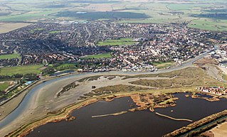
Maldon is a town and civil parish on the Blackwater estuary in Essex, England. It is the seat of the Maldon District and starting point of the Chelmer and Blackwater Navigation. It is known for Maldon Sea Salt which is produced in the area.

Billericay is a town and civil parish in the Borough of Basildon in Essex, England. It lies within the London Basin and is 25 miles (40 km) east of Central London. The town has a wide variety of open spaces. The town is thought to have been occupied since the Bronze Age.
The City of Chelmsford is a local government district with borough and city status in Essex, England. It is named after its main settlement, Chelmsford, which is also the county town of Essex. As well as the settlement of Chelmsford itself, the district also includes the surrounding rural area and the town of South Woodham Ferrers.
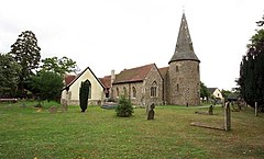
Chignal Smealy is a small village and former civil parish, now in the parish of Chignall, on the north-western outskirts of Chelmsford, in the Chelmsford district, in the county of Essex, England. The local church is a red brick building, containing an unusual red brick baptismal font which has been used for many christenings. In 1881 the parish had a population of 134. On 24 March 1888 the parish was abolished to form Chignall.

Shenfield is a suburb of Brentwood in the Borough of Brentwood in Essex, England. In 2020, the village was estimated to have a population of 5,396.

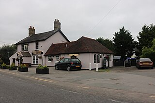
Alresford is a village and electoral ward in Essex, England. It is centred 9 km (5.6 mi) southeast of Colchester and is 39 km (24 mi) northeast from the county town of Chelmsford. The village and its civil parish are the district of Tendring. The local primary school is Alresford Primary School and the village has a pre-school and church. Alresford won the Essex Village of the year competition in 2012 and tied for first place for another Essex Village of the Year award in 2019.

Heybridge is a large village and civil parish in the Maldon district of Essex, England. It is adjacent to the town of Maldon, near the River Blackwater. The parish had a population of 8,163 in 2021.
Galleywood is a village surrounded by countryside in Essex; it is situated on the outskirts of the city of Chelmsford, about 30 miles from London. The A12 trunk road passes nearby, which connects to the M25 in London. Galleywood sits astride a Roman road running south from Chelmsford towards Vange Creek; currently, the B1007 Stock Road and B1009 Beehive Lane run through it. Galleywood was a part of the Great Baddow parish, comprising two villages or hamlets: Galleywood and Galleyend, about a mile apart. Galleywood has a population of 5,700 and has a higher percentage of retired citizens than the national average. Galleywood Common is approximately 400 yards in width and one mile in length, consisting of open fields and woodland. It also has St. Michael's Church in the woodland, which is visible for many miles around.

Tolleshunt D'Arcy is a village situated on the Blackwater estuary in the Maldon District of Essex, England. The village is 12 miles (19 km) southwest of Colchester, 19 miles (31 km) east of Chelmsford and 30 miles (48 km) north of Southend-on-Sea.

Tolleshunt Major is a small village approximately five miles north east of Maldon, in the Maldon District of Essex, England. It forms part of the electoral ward of Tolleshunt D'Arcy and is situated on the northern bank of the River Blackwater.

Chelmer Village is a housing, retail and industrial development in the east of Chelmsford, Essex. The development was started by Countryside Residential PLC in 1978, using a holistic approach to create a self-contained community on previously greenfield land, of the manors of Springfield Barnes and Cuton Hall. It comprises a variety of modern suburban dwellings, the Chelmer Village Retail Park and Dukes Park Industrial Estate.
Chelmer Valley High School (CVHS) is an academy based on a large site on the outskirts of Chelmsford, Essex, England. It has specialisms in engineering, and is assessed as one of the best performing comprehensive schools in Essex; it was given an "outstanding" rating by Ofsted in 2007, and as "good" in 2013. The school also received an Ofsted rating of "good" in 2017.

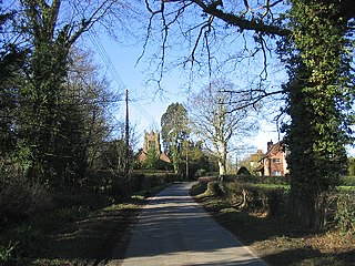
Great Totham is a village and civil parish in Maldon district, Essex, England, and midway between Chelmsford and Colchester. The village includes the Island of Osea in the Blackwater estuary and is separated into two parts, north and south. The north side and the south side are about a mile and a half apart, distributed along the B1022. The parish contains the hamlet of Totham Hill.

Springfield is a civil parish of the Borough of Chelmsford in Essex, England, which is now a north-eastern suburb of the city of Chelmsford.

Little Waltham is a village and civil parish just north of Chelmsford, in Essex, England. It is adjacent to the village of Great Waltham. The Domesday Book refers to the two villages as Waltham, consisting of several manors. The site of an Iron Age village was excavated before upgrading the main road north between the current villages.

Moulsham is a suburb of Chelmsford, Essex, England. It is located to the south of the city centre and has two distinct areas: Old Moulsham and Moulsham Lodge.