Great Baddow is an urban village and civil parish in the Chelmsford borough of Essex, England. It is close to the city of Chelmsford and, with a population of over 13,000,[2] is one of the largest villages in the country.
Great Baddow's name is believed to have been derived from the River Beadwan, now known as the River Chelmer, which marks the northern boundary of the village. Beadwan is thought to be a Celtic word of uncertain meaning,[3] possibly birch stream or a reference to the goddess Badbh.[2]
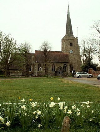
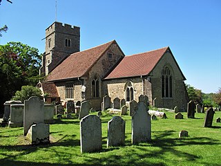
According to information in the local Church of St Mary, the rebel leader Jack Straw led an ill-fated crowd (the men of Essex) from the churchyard to London, in one of the risings in the 1381 Peasants' Revolt.
In 1731, Jasper Jeffrey founded Great Baddow Free School and, in 1830, two National Schools were built. By 1933, there were 7 daily schools, 2 daily and Sunday schools, and a further 2 boarding schools.
Great Baddow is recorded as having had a population of 1,445 in 1801, a figure that had risen to 2,022 in 1841. White's Directory of Essex 1848 reports Great Baddow as being 'one of the handsomest villages in Essex' having 'many scattered farms and neat houses', also noting that it had an annual pleasure fair on 14 May.
Following the Poor Law Amendment Act 1834, responsibility for the poor of Great Baddow was removed from the parish and transferred to the Chelmsford Union on 10 August 1835.[7]
The Post Office Directory of Essex 1851, which lists the principal residents and trade persons of the parish of Great Baddow, includes 24 farmers, 8 beer retailers, 4 shoemakers, 3 blacksmith, 2 dressmakers and notes that the vicar is residing in the Vineyards.
The Great Baddow Mast – a former Chain Homeradar transmitter tower, originally sited at RAF Canewdon– was moved to the outskirts of Great Baddow at around 1954 and is used by BAE Systems for equipment testing.[8] The last remaining example of a Chain Home tower maintaining its platforms, it was made a listed building by Historic England in October 2019 and given a Grade II status.[9]
Development
During the early part of the 20th century, Great Baddow grew through ribbon development towards Chelmsford and Galleywood. In 1936, Marconi's Wireless Telegraph Company opened the Marconi Research Laboratory in Great Baddow (now BAE Systems Applied Intelligence Laboratories), bringing together their various radio, television and telephony research teams in a single location.[10] As the electronics industry developed, the campus expanded during the 1940s and 1950s to include research into radar, general physics, high voltage, vacuum physics and semiconductors.[10] Great Baddow expanded considerably in the 1950s with the construction of Rothmans Estate, which provided housing for workers at Marconi's and English Electric Valve Company in Chelmsford.[11] The village has continued to expand over subsequent years.
The Vineyards, in the centre of the old village, was once a Georgian house set in wooded grounds[12] which later became a hotel. It was demolished in the mid-1960s[13] before the advent of conservation legislation,[12] to make way for the construction of the Vineyards shopping centre and later the Marrable House office block, both constructed with a 'scale, form, layout and architecture' that Chelmsford Council now considers to 'jar with its historic surroundings'.[12] Despite this, the shopping centre continues to thrive[12] and, since refurbishment in the 2000s, the flats above are highly regarded and sought-after properties.[citation needed] Marrable House, a six-storey office block was described at the time of its construction in 1968 as "one of the worst examples of town and country planning in the country"[14] and subsequently once voted as one of England's ugliest buildings,[13][15] was demolished in the Spring of 2016,[16] and was replaced with a 53-flat development, made up of one to two bedrooms in two buildings, named Heron Gate; the development was completed in spring 2018.[17][18] A corner of the grounds of the former Vineyards mansion were retained and form a green area to the west of the Vineyards development.[12] A library was also opened on the western edge of the development in September 1981, replacing the former building in Bell Street.[19]
In 1967, a fire station was opened in Great Baddow to replace the former station which occupied a converted hut in Brewery Fields, Galleywood; it was once part of the Galleywood race course complex.
Great Baddow has three pubs: the White Horse, Blue Lion and The Star; The Beehive and King's Head pubs have closed in recent times. There is also a family-run brewery, the Chelmsford Brewing Company.[20] The former Baddow Brewery, previously owned by the Baddow Brewery Co Ltd,[21] built in 1868 and extended in 1878 by George Scamell, is now a Grade II building and houses local businesses.[22][23] Great Baddow is also home to the Pontlands Park Country Hotel and the Baddow Antique Centre.
Great Baddow lies to the south east to central Chelmsford, on higher ground that is thought to mark the edge of the main ice mass during the Anglian glaciation.[24] An outcrop of glacial sand and gravel 3km long and 0.8km wide is beneath the village, which used to be extracted from several pits in the area, including Beehive Pit (now beneath Harbeard Tye), Baddow Hall Pit (now beneath Baden-Powell Close), to the south of the A1114 Princes Road (now in the grounds of Moulsham High School) and on what is now an area of open land off Waterson Vale.[24] Smaller pits were also located off the Galleywood Road (near what is now Hollywood Close)[24] and off Pitt Chase. The area is overlain with head, while the lower levels of the sand and gravel are mixed with London Clay.[24] A Sarsen stone from the Beehive Pit used to stand outside The Beehive pub.[24]
Education
The village secondary school is Great Baddow High School, a sports and science college on Duffield Road. Primary schools include Baddow Hall Infant and Junior Schools at the border of Great Baddow, Beehive Lane County Primary School, Larkrise Primary School, (formerly Rothmans Primary School), and Meadgate County Primary Schools.
The Chelmer and Blackwater Navigation is the canalisation of the Rivers Chelmer and Blackwater in Essex, in the east of England. The navigation runs for 13.75 miles (22.13 km) from Springfield Basin in Chelmsford to the sea lock at Heybridge Basin near Maldon. Initial plans faced spirited opposition from Maldon, which were overcome by avoiding the town and terminating at Heybridge, and the navigation opened in 1797. There were some teething problems, and the engineer John Rennie was called back on two occasions to recommend improvements. The impact of the railways was less severe than on many canals, as there was never a direct line between Chelmsford and Maldon. The sea lock at Heybridge was enlarged after the Second World War, but trade gradually declined and ceased in 1972.
Chelmsford is a city in the City of Chelmsford district in the county of Essex, England. It is the county town of Essex and one of three cities in the county, along with Colchester and Southend-on-Sea. It is located 30 miles north-east of London at Charing Cross and 22 miles south-west of Colchester. The population of the urban area was 110,625 in the 2021 Census, while the wider district has 181,763.
Danbury is a village in the City of Chelmsford district, in the county of Essex, England. It is located 33.5 miles (53.9 km) northeast of Charing Cross, London and has a population of approximately 6,500. It is situated on a hill 367 feet (112 m) above sea level.
The City of Chelmsford is a local government district with borough and city status in Essex, England. It is named after its main settlement, Chelmsford, which is also the county town of Essex. As well as the settlement of Chelmsford itself, the district also includes the surrounding rural area and the town of South Woodham Ferrers.
Boreham is a village and civil parish, in Essex, England. The parish is in the City of Chelmsford and Chelmsford Parliament constituency. The village is approximately 3.7 miles (6.0 km) northeast from the county town of Chelmsford.
Felsted is a village and civil parish in the Uttlesford district of Essex, England. The civil parish includes the hamlets of Bannister Green, Bartholomew Green, Causeway End, Coblers Green, Cock Green, Frenches Green, Gransmore Green, Hartford End, Molehill Green, Milch Hill, Thistley Green, Watch House Green and Willows Green.
Broomfield is a village and residential suburb in the City of Chelmsford district, immediately north of the city itself. It is the site of a major Accident & Emergency hospital. There are two public houses as well as primary and secondary schools and sports clubs.
Chelmsford is a constituency in Essex represented in the House of Commons of the UK Parliament since 2017 by Vicky Ford of the Conservative Party.
Chelmsford City Council in Essex, England is elected every four years. Since the last boundary changes in 2003 the council has comprised 57 councillors elected from 24 wards.
Galleywood is a village surrounded by countryside in Essex; it is situated on the outskirts of the city of Chelmsford, about 30 miles from London. The A12 trunk road passes nearby, which connects to the M25 in London. Galleywood sits astride a Roman road running south from Chelmsford towards Vange Creek; currently, the B1007 Stock Road and B1009 Beehive Lane run through it. Galleywood was a part of the Great Baddow parish, comprising two villages or hamlets: Galleywood and Galleyend, about a mile apart. Galleywood has a population of 5,757 and has a higher percentage of retired citizens than the national average. Galleywood Common is approximately 400 yards in width and one mile in length, consisting of open fields and woodland. It also has St. Michael's Church in the woodland, which is visible for many miles around.
Little Baddow is a village to the east of Chelmsford, Essex.
Sandon is a village and civil parish just off junction 17 of the A12 in Essex, England, adjacent to Great Baddow and close to Danbury. The population taken at the 2011 Census includes Howe Green and totals 1,613. It was known for an ancient oak tree covering most of the village green. This rare Spanish oak was planted in 1888 to mark Queen Victoria's Golden Jubilee. It was removed for safety reasons in 2000 after collapsing due to long-standing fungal infection. Three new oak trees were planted on the village green to continue its legacy and mark Queen Elizabeth II's Golden Jubilee.
Stock is a village and civil parish in south Essex, England. It is about 6 miles (10 km) south of Chelmsford, the county town. The village is in the borough of Chelmsford and in the parliamentary constituency of Maldon.
The Chelmsford Museum is based in Oaklands House, an historic property off Moulsham Street in Chelmsford, Essex. It is a Grade II Listed building.
Little Waltham is a village and civil parish just north of Chelmsford, in Essex, England. It is adjacent to the village of Great Waltham. The Domesday Book refers to the two villages as Waltham, consisting of several manors. The site of an Iron Age village was excavated before upgrading the main road north between the current villages.
Moulsham is a suburb of Chelmsford, Essex, England. It is located to the south of the city centre and has two distinct areas: Old Moulsham and Moulsham Lodge.
St Mary's Church is an active parish church in the village of Great Baddow, Essex, England. The church stands on the High Street in the centre of the village and dates from the 12th century. Much extended in the 16th century, and heavily restored in the 19th and 20th centuries, the church is a Grade I listed building.
The 2023 Chelmsford City Council election took place on 4 May 2023 to elect members of Chelmsford City Council in Essex, England. This was on the same day as other local elections across England.
This page is based on this Wikipedia article Text is available under the CC BY-SA 4.0 license; additional terms may apply. Images, videos and audio are available under their respective licenses.