Brownville, Nebraska

Last updated

Brownville, Nebraska
Carson house (Brownville, Nebraska) from NE.JPG
Carson House on Main Street, in Brownville Historic District
Nemaha County Nebraska Incorporated and Unincorporated areas Brownville Highlighted.svg
Location of Brownville, Nebraska
Coordinates: 40°23′49″N95°39′34″W / 40.39694°N 95.65944°W / 40.39694; -95.65944
Country United States
State Nebraska
County Nemaha
Area
[1]
  Total0.65 sq mi (1.69 km2)
  Land0.65 sq mi (1.69 km2)
  Water0.00 sq mi (0.00 km2)
Elevation
958 ft (292 m)
Population
 (2020) [2]
  Total142
  Estimate 
(2021) [2]
142
  Density220/sq mi (84/km2)
Time zone UTC-6 (Central (CST))
  Summer (DST) UTC-5 (CDT)
ZIP code
68321
Area code 402
FIPS code 31-06750 [3]
GNIS feature ID0827698 [4]
Website www.brownville-ne.com

Brownville is a village in Nemaha County, Nebraska, United States. The population was 142 at the 2020 census. [2]

Contents

History

Established in 1854 and incorporated in 1856, Brownville was the largest town in the Nebraska Territory, with a population of 1,309 by 1880. Bordering slave-holding Missouri, the town became an important port on the Missouri River. Daniel Freeman, the first homesteader to file a claim under the Homestead Act of 1862, staked his claim at a New Year's Eve party in Brownville.

The rise of the railroad was ultimately Brownville's undoing. The railroads siphoned traffic away from the Missouri River's steamboats. Brownville's attempt to secure a railroad of its own was severely botched and led to immense tax increases to pay the bonds for the failed venture. This drove most of the population away and led to the county seat being transferred to Auburn in 1885. [5] In 1856 Thomas Weston Tipton moved to the town to serve as a minister. He later became a U.S. Senator, and ran an unsuccessful campaign for Governor of Nebraska. Omaha land magnates Herman and Augustus Kountze held large holdings in the early town.

After the American Civil War, David Mercer established a law practice in the town. Mercer later served as a long-time U.S. Representative from Nebraska. The Nebraska State Fair was held in the town in 1870 and 71. That year Eugene Gilmore, the future acting Governor-General of the Philippines, was born in the town.

The Brownville Bridge was built over the Missouri River in 1939. Today it is on the National Register of Historic Places. Owing to its place in Nebraska history, Brownville is primarily a tourist attraction with several old houses opened for tours or converted into museums. Art galleries and wineries in and near Brownville have also helped to make the town an increasingly attractive getaway for residents of the region's larger cities. [6] Omaha's River City Star was built in the town in 1967, and was originally named the Belle of Brownville. The Governor Furnas Arboretum was planted in the city in 1992. The arboretum is named in honor of Nebraska's second governor, Robert W. Furnas, the signer of the first declaration of Arbor Day. The Cooper Nuclear Station is south of the city. In 1995 a mild tornado blew through the town.

Geography

According to the United States Census Bureau, the village has a total area of 0.65 square miles (1.68 km2), all land. [7]

Climate

Climate data for Brownville, Nebraska
MonthJanFebMarAprMayJunJulAugSepOctNovDecYear
Record high °F (°C)70
(21)
81
(27)
91
(33)
99
(37)
102
(39)
109
(43)
110
(43)
109
(43)
107
(42)
98
(37)
84
(29)
78
(26)
110
(43)
Mean daily maximum °F (°C)34
(1)
41
(5)
53
(12)
65
(18)
76
(24)
86
(30)
90
(32)
88
(31)
80
(27)
68
(20)
50
(10)
37
(3)
64
(18)
Mean daily minimum °F (°C)14
(−10)
20
(−7)
30
(−1)
41
(5)
52
(11)
62
(17)
66
(19)
64
(18)
55
(13)
43
(6)
30
(−1)
18
(−8)
41
(5)
Record low °F (°C)−22
(−30)
−23
(−31)
−21
(−29)
7
(−14)
26
(−3)
39
(4)
43
(6)
38
(3)
23
(−5)
13
(−11)
−5
(−21)
−27
(−33)
−27
(−33)
Average precipitation inches (mm)0.84
(21)
1.09
(28)
2.46
(62)
2.93
(74)
4.27
(108)
3.73
(95)
4.41
(112)
3.49
(89)
3.54
(90)
2.49
(63)
2.02
(51)
1.09
(28)
32.36
(821)
Average snowfall inches (cm)5.7
(14)
6.2
(16)
5.3
(13)
1
(2.5)
0
(0)
0
(0)
0
(0)
0
(0)
0
(0)
0.2
(0.51)
1.7
(4.3)
5.7
(14)
25.8
(64.31)
Source: [8]

Demographics

Historical population
CensusPop.Note
1860 425
1870 1,305207.1%
1880 1,3090.3%
1890 980−25.1%
1900 718−26.7%
1910 457−36.4%
1920 4631.3%
1930 426−8.0%
1940 58136.4%
1950 357−38.6%
1960 243−31.9%
1970 174−28.4%
1980 20316.7%
1990 148−27.1%
2000 146−1.4%
2010 132−9.6%
2020 1395.3%
2021 (est.)142 [2] 2.2%
U.S. Decennial Census [9]

2010 census

As of the census [10] of 2010, there were 132 people, 73 households, and 40 families residing in the village. The population density was 203.1 inhabitants per square mile (78.4/km2). There were 103 housing units at an average density of 158.5 per square mile (61.2/km2). The racial makeup of the village was 97.7% White, 0.8% Native American, 0.8% from other races, and 0.8% from two or more races. Hispanic or Latino of any race were 3.0% of the population.

There were 73 households, of which 9.6% had children under the age of 18 living with them, 46.6% were married couples living together, 1.4% had a female householder with no husband present, 6.8% had a male householder with no wife present, and 45.2% were non-families. 42.5% of all households were made up of individuals, and 20.5% had someone living alone who was 65 years of age or older. The average household size was 1.81 and the average family size was 2.30.

The median age in the village was 60.8 years. 6.8% of residents were under the age of 18; 6.9% were between the ages of 18 and 24; 7.6% were from 25 to 44; 40.1% were from 45 to 64; and 38.6% were 65 years of age or older. The gender makeup of the village was 53.0% male and 47.0% female.

2000 census

As of the census [3] of 2000, there were 146 people, 74 households, and 40 families residing in the village. The population density was 233.9 inhabitants per square mile (90.3/km2). There were 106 housing units at an average density of 169.8 per square mile (65.6/km2). The racial makeup of the village was 99.32% White, and 0.68% from two or more races.

There were 74 households, out of which 20.3% had children under the age of 18 living with them, 44.6% were married couples living together, 5.4% had a female householder with no husband present, and 44.6% were non-families. 40.5% of all households were made up of individuals, and 17.6% had someone living alone who was 65 years of age or older. The average household size was 1.97 and the average family size was 2.63.

In the village, the population was spread out, with 18.5% under the age of 18, 5.5% from 18 to 24, 19.2% from 25 to 44, 34.2% from 45 to 64, and 22.6% who were 65 years of age or older. The median age was 51 years. For every 100 females, there were 117.9 males. For every 100 females age 18 and over, there were 108.8 males.

The median income for a household in the village was $34,375, and the median income for a family was $51,000. Males had a median income of $35,750 versus $28,438 for females. The per capita income for the village was $20,928. There were 11.5% of families and 15.9% of the population living below the poverty line, including 15.2% of under eighteens and 17.9% of those over 64.

Places

Brownville sits in the Loess Hills above the Missouri River Valley. It is home to one of Nebraska's two nuclear power plants. The Cooper Nuclear Station is owned and operated by the Nebraska Public Power District. U.S. Route 136, which meets Nebraska Highway 67 near Brownville, runs through the town, exiting the state via the Brownville Bridge. At Brownville bicycle riders along the Lewis & Clark Trail Bicycle Route can choose between the Steamboat Trace or the Hamburg Option.

Notable people

Cultural references

Related Research Articles

<span class="mw-page-title-main">Nemaha County, Nebraska</span> County in Nebraska, United States

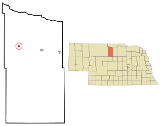
Nemaha County is a county in the U.S. state of Nebraska. As of the 2020 United States Census, the population was 7,074. Its county seat is Auburn.

<span class="mw-page-title-main">Holstein, Nebraska</span> Village in Adams County, Nebraska, United States

Holstein is a village in Adams County, Nebraska, United States. The population was 188 at the 2020 census. It is part of the Hastings, Nebraska Micropolitan Statistical Area.

<span class="mw-page-title-main">Petersburg, Nebraska</span> Village in Nebraska, United States

Petersburg is a village in Boone County, Nebraska, United States. The population was 333 at the 2010 census. Petersburg is the site of a memorial to Logan Fontenelle, an Omaha chief who was killed nearby, in a skirmish with Brulé and Arapaho in 1855, at the site of the present-day Olson Nature Preserve.

<span class="mw-page-title-main">Johnstown, Nebraska</span> Village in Brown County, Nebraska, United States

Johnstown is a village in Brown County, Nebraska, United States. The population was 64 at the 2010 census.

<span class="mw-page-title-main">Decatur, Nebraska</span> Village in Nebraska, United States

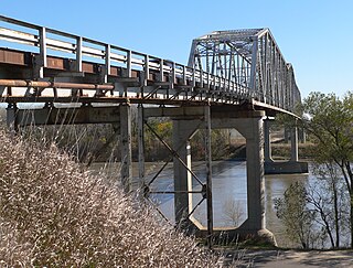
Decatur is a village in Burt County, Nebraska, United States, adjacent to the upper Missouri River. The population was 481 at the 2010 census. This town is named after one of its incorporators, Stephen Decatur. It developed around a trading post established by Colonel Peter Sarpy, the namesake for Sarpy County in the state.

<span class="mw-page-title-main">Bruno, Nebraska</span> Village in Nebraska, United States

Bruno is a village in Butler County, Nebraska, United States. The population was 99 at the 2010 census.

<span class="mw-page-title-main">Octavia, Nebraska</span> Village in Nebraska, United States

Octavia is a village in Butler County, Nebraska, United States. The city had 127 residents as of 2010 census, according to the United States Census Bureau.

<span class="mw-page-title-main">Nehawka, Nebraska</span> Village in Nebraska, United States

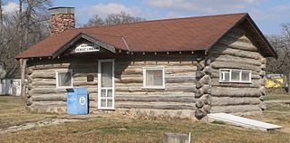
Nehawka is a village in southeast Cass County, Nebraska, United States. The population was 173 at the 2020 census.

<span class="mw-page-title-main">Ponca, Nebraska</span> City in and county seat of Dixon County, Nebraska, U.S.

Ponca is a city and county seat of Dixon County, Nebraska, United States. The population was 961 at the 2010 census.

<span class="mw-page-title-main">Bennington, Nebraska</span> City in Douglas County, Nebraska, United States

Bennington is a city in Douglas County, Nebraska, United States. The population was 2,026 at the 2020 U.S. Census.

<span class="mw-page-title-main">Niobrara, Nebraska</span> Village in Knox County, Nebraska, United States

Niobrara is a village in Knox County, Nebraska, United States. The population was 363 at the 2020 census.

<span class="mw-page-title-main">Auburn, Nebraska</span> City in Nebraska, United States

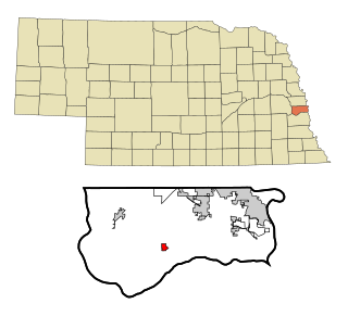
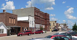
Auburn is a city in Nemaha County, Nebraska, United States, and its county seat. The population was 3,470 at the 2020 census.

<span class="mw-page-title-main">Creston, Nebraska</span> Village in Platte County, Nebraska, United States

Creston is a village in Platte County, Nebraska, United States. The population was 203 at the 2010 census.

<span class="mw-page-title-main">Dorchester, Nebraska</span> Village in Nebraska, United States

Dorchester is a village in Saline County, Nebraska, United States. It is thirty-eight miles southwest from the Lincoln, Nebraska metropolitan area. The population was 596 at the 2020 census.

<span class="mw-page-title-main">Bellevue, Nebraska</span> City in Sarpy County, Nebraska, United States

Bellevue is a suburban city in Sarpy County, Nebraska, United States. It is part of the Omaha–Council Bluffs metropolitan area, and had a population of 64,176 as of the 2020 census, making it the 3rd most populous city in Nebraska, behind Omaha and Lincoln, and the second largest city in the U.S. named "Bellevue," behind Bellevue, Washington.

<span class="mw-page-title-main">Springfield, Nebraska</span> City in Sarpy County, Nebraska, United States

Springfield is a city in Sarpy County, Nebraska, United States. The population was 1,501 at the 2020 census.

<span class="mw-page-title-main">Pender, Nebraska</span> Village in and county seat of Thurston County, Nebraska, United States

Pender is a village in and the county seat of Thurston County, Nebraska, United States. On March 22, 2016, the United States Supreme Court resolved a disagreement as to whether Pender is located on the Omaha Indian Reservation, holding unanimously that "the disputed land is within the reservation’s boundaries." The predominantly European-American population was 1,115 at the 2020 census.

<span class="mw-page-title-main">Kennard, Nebraska</span> Village in Washington County, Nebraska, United States

Kennard is a village in Washington County, Nebraska, United States. The population was 361 at the 2010 census.

Glen Park is a village in Jefferson County, New York, United States. The population was 502 at the 2010 census. The village is on the border of the towns of Brownville and Pamelia and is immediately northwest of Watertown.

<span class="mw-page-title-main">Brownville (village), New York</span> Village in New York, United States

Brownville is a village in Jefferson County, New York, United States. The population was 1,119 at the 2010 census, up from 1,022 in 2000. The village is named after Jacob Brown, an early settler and developer.

References

  1. "ArcGIS REST Services Directory". United States Census Bureau. Retrieved September 18, 2022.
  2. 1 2 3 4 Bureau, US Census. "City and Town Population Totals: 2020—2021". Census.gov. US Census Bureau. Retrieved October 20, 2022.
  3. 1 2 "U.S. Census website". United States Census Bureau . Retrieved January 31, 2008.
  4. "US Board on Geographic Names". United States Geological Survey. October 25, 2007. Retrieved January 31, 2008.
  5. Brownville’'s 150th Anniversary 1854 - 2004: The Village of Firsts Remains on the Frontier Edge Archived November 3, 2005, at the Wayback Machine . Captain Meriwether Lewis Museum. Retrieved 12/13/08.
  6. McCauley, Tom (May 19, 2015). "The Creative Spirit of Brownville: Short on Population, Long on Culture". Omaha Magazine. Retrieved June 22, 2016.
  7. "US Gazetteer files 2010". United States Census Bureau. Archived from the original on July 2, 2012. Retrieved June 24, 2012.
  8. "Intellicast | Weather Underground".
  9. "Census of Population and Housing". Census.gov. Retrieved June 4, 2015.
  10. "U.S. Census website". United States Census Bureau . Retrieved June 24, 2012.