Brunswick and Topsham Water District (Maine)

Last updated
Brunswick and Topsham
Water District
Brunswick and Topsham Water District.jpg
Main offices, c.2022
Agency overview
FormedFebruary 24, 1903 (1903-02-24)
Preceding agency
  • Maine Water Company
Jurisdiction U.S. state of Maine
Headquarters276 River Road
Topsham, Maine
United States
43°56′24″N70°00′14″W / 43.9399°N 70.0038°W / 43.9399; -70.0038
Website www.btwater.org

Established in 1903, the Brunswick and Topsham Water District is a fresh water supply district providing fresh water to the towns of Brunswick and Topsham, Maine through groundwater sources. The Water District is a collaboration between the two towns to ensure safe drinking water as well as water supply for the use of fire suppression systems.

Contents

History

19th century

In the summer of 1828, prior to the establishment of the district, a force pump was constructed at the upper dam of Pejepscot Falls in Brunswick, Maine. This pump utilized hydropower to force water from the Androscoggin River through a pipeline and into a large holding tank. The water then flowed via gravity through pipes to Maine Street a , where it continued to flow through a water tower and alongside a street gutter until it reached a cove and entered the Androscoggin River. This system was in operation well before the establishment of the district. [1]

During summer, this setup functioned smoothly. However, come winter, the water in the gutter would freeze, causing the street and sidewalks to become flooded and covered with ice over long stretches. The aim of this private initiative was to safeguard individuals' property against fire damage, but it was ultimately discontinued. [1]

In 1885, the towns of Brunswick and Topsham, Maine held a special meeting where they authorized the Selectmen to enter into a contract with the Pejepscot Water Company. The contract was for the supply of water for domestic use, including fire fighting, and to provide for all town buildings, schools, drinking fountains, and firefighting hoses. The contract was worth $ 2,000 per year and covered the installation of fifty to sixty fire hydrants. Initially, the Pejepscot Water Company drew water from the Androscoggin River, but it was deemed unsatisfactory. To improve the quality of water, the Warren Filtration Pump Station was constructed in 1887. However, the selected filter did not use coagulants, making it ineffective in removing smaller particles. [2]

Weston Thompson (1850-1907) Served as Trustee from 1903 to 1906 and as president in 1903 and 1906 Weston Thompson.jpg
Weston Thompson (1850-1907) Served as Trustee from 1903 to 1906 and as president in 1903 and 1906

A well was dug at Mere Brook in Brunswick with the aim of improving the quality of water. Although it was reported to be of good quality, it was not further developed. The Pejepscot Water Company sold its assets to the Maine Water Company on July 3, 1891, amidst these difficulties. The Bath Water Supply Company's assets were also acquired by the Maine Water Company in the same year. [2]

20th century

The Maine Legislature incorporated the Brunswick and Topsham Water District in 1903. It took over the assets of the Maine Water Company, which had been serving Brunswick as a privately owned company. The District's primary objective was to find a suitable supply source and offer better service to its clients. In 1908, the system was expanded to provide Topsham with drinking water distribution and reliable fire protection. [3]

At the District's inception, Brunswick and Topsham had a combined populace of 8,800 individuals. However, the incorporation of Topsham mandated a reevaluation of groundwater supply locations. With a thriving industry and an influx of new residents, the demand for an expanded water supply became imperative. [3]

In 1912, the Jordan Avenue pumping station was built in 1905. As consumption rates continued to rise, the District built three high-capacity wells in the Jordan Avenue well field in 1929 since the current wellfields were no longer sufficient. [3]

Jordan Avenue Pumping Station during the 1936 Northeastern United States flood Jordan ave.jpg
Jordan Avenue Pumping Station during the 1936 Northeastern United States flood

In the 1930s, the population was on the rise and had reached approximately 11,500 people. The need for an adequate water supply had become a concern, especially when a severe flood hit Brunswick and Topsham in 1936, which inundated the pumping station with 15 feet (4.6 m) of water. To prevent damage from future floods, the pumping station needed to be flood-proofed, which was deemed too expensive. As a result, the District decided to look for a new groundwater source and storage facility to accommodate both the current and future supply demands. In 1939, a new steel standpipe was installed off River Road in Brunswick to replace the Marrison Farm Hill Tank built in 1886 and provide additional storage capacity. [3]

During the 1970s and 1980s, there were notable changes in the water district. Specifically, in 1971, the Jackson Station was built on River Road in Topsham. This station included a treatment plant and offices, which allowed the district to relocate its main office from 11 Town Hall Place in Brunswick. Additionally, a new well and pump station were constructed at the new location, enhancing the district's capacity to provide consistent water service in the event of a pump station failure. Over the past two decades, the system has grown rapidly and in 1988, a new storage tank was built on Church Road in Brunswick with a storage capacity of 3.0 million gallons to meet the demand for increased storage. [3]

21st century

The District started collecting field data for new main installs and replacements by utilizing barcodes on pipes, hydrants, and valves. Additionally, the District has adopted the latest water metering technologies. [4]

2015 Data [2]
Treatment process
Pipe length121.1 miles (194.9 km)
Daily demand1.62 miles per US gallon (0.69 km/L)
Treatment plants
  • Jackson Station
  • Jordan Station
  • Taylor Station
Population Served17,100

Notes

a. ^ "Maine Street" is the correct spelling

Related Research Articles

<span class="mw-page-title-main">Fire engine</span> Emergency vehicle intended to put out fires

A fire engine is a road vehicle that functions as a firefighting apparatus. The primary purposes of a fire engine include transporting firefighters and water to an incident as well as carrying equipment for firefighting operations in a fire drill. Some fire engines have specialized functions, such as wildfire suppression and aircraft rescue and firefighting, and may also carry equipment for technical rescue.

<span class="mw-page-title-main">Brunswick, Maine</span> Town in Maine, United States

Brunswick is a town in Cumberland County, Maine, United States. The population was 21,756 at the 2020 United States Census. Part of the Portland-South Portland-Biddeford metropolitan area, Brunswick is home to Bowdoin College, the Bowdoin International Music Festival, the Bowdoin College Museum of Art, the Peary–MacMillan Arctic Museum, and the Maine State Music Theatre. It was formerly home to the U.S. Naval Air Station Brunswick, which was permanently closed on May 31, 2011, and has since been partially released to redevelopment as "Brunswick Landing".

<span class="mw-page-title-main">Androscoggin River</span> River in New Hampshire and Maine, United States

The Androscoggin River is a river in the U.S. states of Maine and New Hampshire, in northern New England. It is 178 miles (286 km) long and joins the Kennebec River at Merrymeeting Bay in Maine before its water empties into the Gulf of Maine on the Atlantic Ocean. Its drainage basin is 3,530 square miles (9,100 km2) in area. The name "Androscoggin" comes from the Eastern Abenaki term /aləssíkɑntəkw/ or /alsíkɑntəkw/, meaning "river of cliff rock shelters" ; or perhaps from Penobscot /aləsstkɑtəkʷ/, meaning "river of rock shelters". The Anglicization of the Abenaki term is likely an analogical contamination with the colonial governor Edmund Andros.

<span class="mw-page-title-main">Halifax Water</span> The Robie Street Reservoir in Halifax

The Halifax Regional Water Commission (HRWC), publicly known as Halifax Water, is the municipal water, wastewater and stormwater utility serving the residents of the Halifax Regional Municipality (HRM), pursuant to the Public Utilities Act. An autonomous, self-financed utility, Halifax Water is a fully metered water utility providing water, fire protection, wastewater and stormwater services as regulated by the Nova Scotia Utility and Review Board.

<span class="mw-page-title-main">Androscoggin Swinging Bridge</span> Historic Suspension footbridge on the Androscoggin River

The Androscoggin Swinging Bridge is a pedestrian suspension bridge spanning the Androscoggin River in Maine between the towns of Topsham in Sagadahoc County and Brunswick in Cumberland County. The bridge was built in 1892 as a timesaving approach for employees of the Cabot Manufacturing Company of Brunswick, could have safer and easier passage across the river.

<span class="mw-page-title-main">Water management in Greater Mexico City</span>

Greater Mexico City, a metropolitan area with more than 19 million inhabitants including Mexico's capital with about 9 million inhabitants, faces tremendous water challenges. These include groundwater overexploitation, land subsidence, the risk of major flooding, the impacts of increasing urbanization, poor water quality, inefficient water use, a low share of wastewater treatment, health concerns about the reuse of wastewater in agriculture, and limited cost recovery. Overcoming these challenges is complicated by fragmented responsibilities for water management in Greater Mexico City:

<span class="mw-page-title-main">Pejepscot Paper Company</span>

The Pejepscot Paper Company mill building is a historic paper mill located off U.S. 201 in Topsham, Maine, on the banks of the Androscoggin River, adjacent from Brunswick Falls and the Frank J. Wood Bridge. Built in 1868, the building is one of the oldest surviving paper mills in the state of Maine. The mill was added to the National Register of Historic Places on September 17, 1974, and is now a mixed-use commercial property, housing the Sea Dog Brewing Company.

<span class="mw-page-title-main">Water storage</span> Storage of water by various means

Water storage is a broad term referring to storage of both potable water for consumption, and non potable water for use in agriculture. In both developing countries and some developed countries found in tropical climates, there is a need to store potable drinking water during the dry season. In agriculture water storage, water is stored for later use in natural water sources, such as groundwater aquifers, soil water, natural wetlands, and small artificial ponds, tanks and reservoirs behind major dams. Storing water invites a host of potential issues regardless of that water's intended purpose, including contamination through organic and inorganic means.

<span class="mw-page-title-main">Topsham, Maine</span> Town in the state of Maine, United States

Topsham is a town in Sagadahoc County, Maine, United States. The population was 9,560 at the 2020 census. It is part of the Portland–South Portland–Biddeford, Maine metropolitan statistical area. The town is home to the annual Topsham Fair.

<span class="mw-page-title-main">Brunswick Commercial Historic District</span> Historic district in Brunswick, Maine, U.S.

The Brunswick Commercial Historic District encompasses the historic late-19th century commercial core of Brunswick, Maine. It includes the northern four blocks of Maine Street, the town's principal commercial thoroughfare, which was laid out in the late 17th century. The district was listed on the National Register of Historic Places in 2016.

<span class="mw-page-title-main">Cathance Water Tower</span> United States historic place

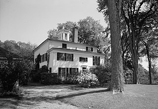
The Cathance Water Tower is a historic water tower at Cathance Road and Beechwood Drive in Topsham, Maine. Probably built in the late 19th century, it is an extremely rare surviving example of a residential wooden water tower built for a single residence. It was listed on the National Register of Historic Places in 2001. It is now owned by the town.

<span class="mw-page-title-main">Topsham Historic District</span> Historic district in Maine, United States

The Topsham Historic District encompasses the historic village center of Topsham, Maine. Extending along parts of Elm, Green, and Pleasant Streets, the area has a fine collection of 19th and early 20th-century architecture, with the majority built before 1850. It is almost entirely residential, with only a few non-residential uses, including a church. The district was listed on the National Register of Historic Places in 1978.

<span class="mw-page-title-main">Des Moines Water Works</span> Water utility service for city of Des Moines

The Des Moines Water Works (DMWW) is a publicly owned, municipal water utility with its headquarters in Water Works Park. It was founded 1871 southwest of downtown Des Moines, Iowa, along the Raccoon River and provides water to half a million residents of the greater Des Moines metropolitan area. As of 2017, it has three treatment facilities.

<span class="mw-page-title-main">Frank J. Wood Bridge</span> Road bridge in Maine, US

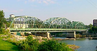
The Frank J. Wood Bridge is a three span, through truss bridge crossing over the Androscoggin River between the towns of Topsham and Brunswick, Maine, on U.S. Route 201. Opened in 1932, the bridge was originally called the Brunswick-Topsham bridge but was officially renamed the Frank J. Wood Bridge, after a local farmer who suggested the location.

<span class="mw-page-title-main">Fort Andross</span> Site of colonial forts & cotton mills, Brunswick Maine

Fort Andross, also known as Fort George and Cabot Mill, originally was a historic trading post and garrison built by the colonial British Empire to fortify against the Wabanaki Native Americans who were aligned with France during King William's War (1688–1697). It was adjacent to Brunswick Falls on the Androscoggin River in Brunswick, Maine. In the 19th century, the location of the fort has been used for several cotton mills including the Cabot Manufacturing Company. In 1986, the mills were transformed into office and retail space and renamed Fort Andross.

<span class="mw-page-title-main">Pejepscot</span> Historical village in Maine

Pejepscot is a historical settlement first occupied by a subset of the Androscoggin Native Americans known as the Wabanaki. The region encompasses the current towns of Brunswick, Topsham and Harpswell, Maine in Sagadahoc and Cumberland counties and was first settled by English settlers in 1628.

Thomas Purchase (1577–1678), also known as Thomas Purchis and Thomas Purchas, was the first English settler to occupy the region of Pejepscot, Maine in what is now Brunswick, Topsham and Harpswell. In 1628 he set up a trading post at the site of Fort Andross to barter with the local Wabanaki Native Americans.

<span class="mw-page-title-main">Brunswick Falls</span> Dam and waterfall in Brunswick and Topsham, Maine

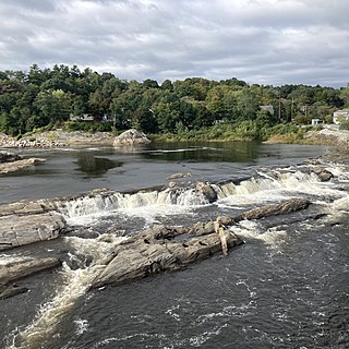
Brunswick Falls, also known as Pejepscot Falls, lie on a rocky section of the Androscoggin River, bordering the towns of Brunswick and Topsham, Maine in the US. First occupied by Paleoindians and the Wabanaki Native Americans, the falls were a plentiful resource for food and trade. Throughout colonial history, the Industrial Revolution, and into the 21st century, the falls have been a vital part of Brunswick and Topsham's economy, harnessing its power for energy development.

<span class="mw-page-title-main">George Augustus Wheeler</span> 1800s Maine historian

George Augustus Wheeler, MD was a surgeon in the American Civil War and a prominent Maine historian. He authored two historical books including History of Brunswick, Topsham, and Harpswell, Maine, which the Pejepscot Historical Society states as the "authoritative text on the three towns through 1878".

<span class="mw-page-title-main">Pejepscot Proprietors</span> Colonial land investors of Maine, U.S.

The Pejepscot Proprietors was a company of land investors who colonized the current towns of Brunswick, Topsham and Harpswell, Maine, between 1715 and 1814.

References

  1. 1 2 Wheeler, George Augustus; Wheeler, Henry Warren (1878). History of Brunswick, Topsham, and Harpswell, Maine: Including the Ancient Territory Known as Pejepscot (1st ed.). Boston: A. Mudge & Sons, Printers. p. 272. LCCN   01008940 via Google Books. (Archive source Harvard Library) PD-icon.svg This article incorporates text from this source, which is in the public domain .
  2. 1 2 3 Douglas, Craig W.; Dow, Riley E. (September 2015). "History of the Brunswick and Topsham Water District" . Journal of the New England Water Works Association. Boston. 129 (3): 149–173. ProQuest   1776117467 . Retrieved 16 November 2022.
  3. 1 2 3 4 5 "History of BTWD". btwater.org. Retrieved June 5, 2023.
  4. "DIPRA Welcomes Brunswick & Topsham Water District to the Century Club". Ductile Iron Pipe Research Association. Hoover, Alabama: PR Newswire. September 2015. Retrieved June 5, 2023.