
Location of Brusnik in Croatia

Map
Brusnik is an uninhabited volcanic island in the Croatian part of the Adriatic Sea. The island is part of the Dalmatian archipelago.
Brusnik is an uninhabited volcanic island in the Croatian part of the Adriatic Sea. The island is part of the Dalmatian archipelago.
The island's name comes from the word brus ("whetstone"), because volcanic rocks from the island were used for making whetstones. [1]

The island is located 12 NM west of Komiža, town on island of Vis, [2] and 2 NM south-west from the island of Svetac (Sv. Andrija).
The area of the island is 3 ha. [3] Brusnik is 320 m long, 205 m wide, and has 30 meter high cliffs. The east coast is steep and difficult to reach, while the west coast is glacis toward the sea.
In 1951, the island was declared a geological monument of nature. On the island, there is the endemic species of black lizard (Podarcis melisellensis melisellensis [4] ). The surrounding sea is rich with fish, especially blue fish.

Dalmatia is one of the four historical regions of Croatia, alongside Central Croatia, Slavonia and Istria, located on the east shore of the Adriatic Sea in Croatia.

Zadar, historically known as Zara, is the oldest continuously inhabited city in Croatia. It is situated on the Adriatic Sea, at the northwestern part of Ravni Kotari region. Zadar serves as the seat of Zadar County and of the wider northern Dalmatian region. The city proper covers 25 km2 (9.7 sq mi) with a population of 75,082 in 2011, making it the second-largest city of the region of Dalmatia and the fifth-largest city in the country.

Split-Dalmatia County is a central-southern Dalmatian county in Croatia. The administrative center is Split. The population of the county is 455,242 (2011). The land area is 14.106,40 km2. Split-Dalmatia County is Croatia's most rapidly urbanising and developing region, as economic opportunities and living standards are among the highest alongside capital Zagreb and Istria County.

Vis is a town on the eponymous island in the Adriatic Sea in southern Croatia. Its population was 1,934 as of 2011. The town is the seat of the eponymous Vis municipality, one of the island's two municipalities. Both belong administratively to Split-Dalmatia County.

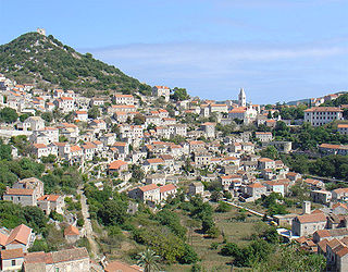
Hvar is a Croatian island in the Adriatic Sea, located off the Dalmatian coast, lying between the islands of Brač, Vis and Korčula. Approximately 68 kilometres (42.25 mi) long, with a high east–west ridge of Mesozoic limestone and dolomite, the island of Hvar is unusual in the area for having a large fertile coastal plain, and fresh water springs. Its hillsides are covered in pine forests, with vineyards, olive groves, fruit orchards and lavender fields in the agricultural areas. The climate is characterized by mild winters, and warm summers with many hours of sunshine. The island has 10,678 residents according to the 2021 census, making it the 4th most populated of the Croatian islands.
Croatian cuisine is heterogeneous and is known as a cuisine of the regions, since every region of Croatia has its own distinct culinary tradition. Its roots date back to ancient times. The differences in the selection of foodstuffs and forms of cooking are most notable between those in mainland and those in coastal regions. Mainland cuisine is more characterized by the earlier Slavic and the more recent contacts with Hungarian and Turkish cuisine, using lard for cooking, and spices such as black pepper, paprika, and garlic. The coastal region bears the influences of Greek and Roman cuisine, as well as of the later Mediterranean cuisine, in particular Italian. Coastal cuisines use olive oil, herbs and spices such as rosemary, sage, bay leaf, oregano, marjoram, cinnamon, clove, nutmeg, and lemon and orange rind. Peasant cooking traditions are based on imaginative variations of several basic ingredients and cooking procedures, while bourgeois cuisine involves more complicated procedures and use of selected herbs and spices. Charcuterie is part of the Croatian culinary tradition in all regions. Food and recipes from other former Yugoslav countries are also popular in Croatia.

Komiža is a Croatian coastal town lying on the western coast of the island of Vis in the central part of the Adriatic Sea. As of 2011 Komiža proper has a population of 1,397 while the entire municipality has 1,526 residents.

Liburnia in ancient geography was the land of the Liburnians, a region along the northeastern Adriatic coast in Europe, in modern Croatia, whose borders shifted according to the extent of the Liburnian dominance at a given time between 11th and 1st century BC. Domination of the Liburnian thalassocracy in the Adriatic Sea was confirmed by several Antique writers, but the archeologists have defined a region of their material culture more precisely in northern Dalmatia, eastern Istria, and Kvarner.
Lastovo is an island municipality in the Dubrovnik-Neretva County in Croatia. The municipality consists of 46 islands with a total population of 792 people, of which 94,7% are ethnic Croats, and a land area of approximately 53 square kilometres (20 sq mi). The biggest island in the municipality is also named Lastovo, as is the largest town. The majority of the population lives on the 46 square kilometres (18 sq mi) island of Lastovo.
Vir is an island on the Croatian coast of the Adriatic Sea with an area of 22 km2. It lies in Dalmatia, north of the city of Zadar. It is connected to the mainland via a road bridge. The main village on the island is the eponymous village of Vir. There are two more villages, Lozice and Torovi. According to the 2011 census, the island had a population of 3,000 inhabitants, making it the 13th most populous island in Croatia.

Biševo is an island in the Adriatic Sea in Croatia. It is situated in the middle of the Dalmatian archipelago, five kilometers southwest of the Island of Vis. Its area is 5.8 km2 (2.2 sq mi) and it has a population of 15.

Sveti Andrija, often called Svetac, is an island in the Croatian part of the Adriatic Sea. It is situated 14 nautical miles (26 km) from Komiža. It is uninhabited, although it used to have permanent residents.

The Governorate of Dalmatia was a territory divided into three provinces of Italy during the Italian Kingdom and Italian Empire epoch. It was created later as an entity in April 1941 at the start of World War II in Yugoslavia, by uniting the existing Province of Zara together with occupied Yugoslav territory annexed by Italy after the invasion of Yugoslavia by the Axis powers and the signing of the Rome Treaties.
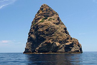
Jabuka is an uninhabited volcanic island in the Adriatic Sea, west of the island of Vis. It is part of the Dalmatian archipelago. The closest land masses are the small islands of Svetac and Brusnik. Jabuka is the farthest from the nearest land mass out of all Croatian islands.
Croatian wine has a history dating back to the Ancient Greek settlers, and their wine production on the southern Dalmatian islands of Vis, Hvar and Korčula some 2,500 years ago. Like other old world wine producers, many traditional grape varieties still survive in Croatia, perfectly suited to their local wine hills. Modern wine-production methods have taken over in the larger wineries and EU-style wine regulations have been adopted, guaranteeing the quality of the wine.
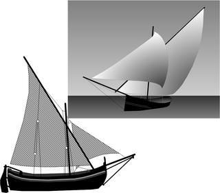
A falkusa is a traditional fishing boat used by fishermen from the town of Komiža on the Adriatic island of Vis, Croatia. Falkuša is a subtype of gajeta, a traditional Dalmatian fishing sailboat, and is sometimes called gajeta falkuša. Its design was adapted to the specific needs of Komiža fishermen, who went to long fishing expeditions in the open seas, a unique practice in the Adriatic and Mediterranean.
The Battle of the Dalmatian Channels was a three-day confrontation between three tactical groups of Yugoslav Navy ships and coastal artillery, and a detachment of naval commandos of the Croatian Navy fought on 14–16 November 1991 during the Croatian War of Independence. On 14 November, the commandos torpedoed the Mirna-class patrol boat PČ-176 Mukos close to the island of Brač in the Split Channel of the Adriatic Sea, prompting a Yugoslav naval bombardment of Brač and Šolta Island the same day. The drifting Mukos was salvaged by Croatian civilian boats and beached at Nečujam bay.
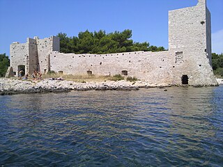
Piškera is a small uninhabited island in the Croatian part of the Adriatic Sea. It is one of the Kornati Islands in central Dalmatia and its area is 2.66 km2. Its coastline is 10.64 km long.

The Theme of Dalmatia was a Byzantine theme on the eastern coast of the Adriatic Sea in Southeastern Europe, headquartered at Jadera.

Topography of Croatia is defined through three major geomorphological parts of the country. Those are the Pannonian Basin, the Dinaric Alps, and the Adriatic Basin. The largest part of Croatia consists of lowlands, with elevations of less than 200 metres above sea level recorded in 53.42% of the country. Bulk of the lowlands are found in the northern regions of the country, especially in Slavonia, itself a part of the Pannonian Basin plain. The plains are interspersed by the horst and graben structures, believed to break the Pannonian Sea surface as islands. The greatest concentration of ground at relatively high elevations is found in Lika and Gorski Kotar areas in the Dinaric Alps, but such areas are found in all regions of Croatia to some extent. The Dinaric Alps contain the highest mountain in Croatia—1,831-metre (6,007 ft) Dinara, as well as all other mountains in Croatia higher than 1,500 metres. Croatia's Adriatic Sea mainland coast is 1,777.3 kilometres long, while its 1,246 islands and islets encompass further 4,058 kilometres of coastline—the most indented coastline in the Mediterranean. Karst topography makes up about half of Croatia and is especially prominent in the Dinaric Alps, as well as throughout the coastal areas and the islands.
43°00′N15°48′E / 43.000°N 15.800°E
| | This Split-Dalmatia County geography article is a stub. You can help Wikipedia by expanding it. |