Buena Vista Park

Last updated
Buena Vista Park
View of San Francisco from Buena Vista Park.jpg
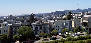
The view from Buena Vista Park
Location map San Francisco County.png
Red pog.svg
Buena Vista Park
Location in San Francisco
USA California location map.svg
Red pog.svg
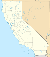
Buena Vista Park
Location in California
Usa edcp location map.svg
Red pog.svg
Buena Vista Park
Location in United States
TypeMunicipal (San Francisco)
Location San Francisco
Coordinates 37°46′06″N122°26′27″W / 37.7683°N 122.4408°W / 37.7683; -122.4408 Coordinates: 37°46′06″N122°26′27″W / 37.7683°N 122.4408°W / 37.7683; -122.4408
Area37 acres (15 ha)
Created1867 (1867)
OpenAll year
Website Official website

Buena Vista Park is a park in the Haight-Ashbury and Buena Vista Heights neighborhoods of San Francisco, California. It is the oldest official park in San Francisco, established in 1867 as Hill Park, later renamed Buena Vista. It is bounded by Haight Street to the north, and by Buena Vista Avenue West and Buena Vista Avenue East. The park is on a steep hill that peaks at 575 feet (175 m), and covers 37 acres (150,000 m2). The lowest section is the north end along Haight.

Park area of open space used for recreation or conservation

A park is an area of natural, semi-natural or planted space set aside for human enjoyment and recreation or for the protection of wildlife or natural habitats. Urban parks are green spaces set aside for recreation inside towns and cities. National parks and Country parks are green spaces used for recreation in the countryside. State parks and Provincial parks are administered by sub-national government states and agencies. Parks may consist of grassy areas, rocks, soil and trees, but may also contain buildings and other artifacts such as monuments, fountains or playground structures. Many parks have fields for playing sports such as soccer, baseball and football, and paved areas for games such as basketball. Many parks have trails for walking, biking and other activities. Some parks are built adjacent to bodies of water or watercourses and may comprise a beach or boat dock area. Urban parks often have benches for sitting and may contain picnic tables and barbecue grills.

Haight-Ashbury Neighborhood in San Francisco, California, United States

Haight-Ashbury is a district of San Francisco, California, named for the intersection of Haight and Ashbury streets. It is also called The Haight and The Upper Haight. The neighborhood is known for being the origin of the hippie counterculture.

Haight Street street in San Francisco, California

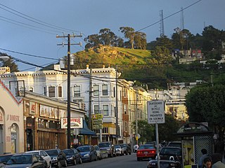
Haight Street, in San Francisco, is the principal street in San Francisco's Haight-Ashbury district, also known as the Upper Haight due to its elevation. The street stretches from Market Street, through the Lower Haight neighborhood, to Stanyan Street in the Upper Haight, at Golden Gate Park. In most blocks it is residential, but in the Upper and Lower Haight it is also a neighborhood shopping street, with residences above the ground floor shops. It is named after California pioneer and exchange banker Henry Haight (1820–1869).

Contents

Layout

The hill on which the park lies is composed primarily of sand and San Francisco chert, formed in the Mesozoic era. The layout of the park uses the steepness of the hill to good advantage, offering good views of the city (particularly to the north).

A broken headstone re-purposed for a rain gutter, located several path tiers up the hill, overlooking Haight Street Buena Vista Park headstone.jpg
A broken headstone re-purposed for a rain gutter, located several path tiers up the hill, overlooking Haight Street

At the peak of the park is a small lawn. Notable views are available from various lookouts lower down, including "The Window," an overlook on the western side of the hill from which there is a sweeping vista of Golden Gate Park, the Pacific Ocean, and, on clear days, northward up the coast to the white cliffs of Drake's Bay.

Golden Gate Park large park in San Francisco, California

Golden Gate Park, located in San Francisco, California, United States, is a large urban park consisting of 1,017 acres (412 ha) of public grounds. It is administered by the San Francisco Recreation & Parks Department, which began in 1871 to oversee the development of Golden Gate Park. Configured as a rectangle, it is similar in shape but 20 percent larger than Central Park in New York, to which it is often compared. It is over three miles (4.8 km) long east to west, and about half a mile (0.8 km) north to south. With 13 million visitors annually, Golden Gate is the fifth most-visited city park in the United States after Central Park in New York City, Lincoln Park in Chicago, and Balboa and Mission Bay Parks in San Diego.

The paths along the west side are lined with gutters built by WPA workers out of broken headstones from the City's Victorian cemeteries at Lone Mountain (i.e. Laurel Heights), which were moved to Colma in the 1930s. [1] In a few cases the inscriptions were placed facing up and can be discerned (Cf. the Wave Organ).

Works Progress Administration largest and most ambitious United States federal government New Deal agency

The Works Progress Administration was an American New Deal agency, employing millions of people to carry out public works projects, including the construction of public buildings and roads. It was established on May 6, 1935, by Executive Order 7034. In a much smaller project, Federal Project Number One, the WPA employed musicians, artists, writers, actors and directors in large arts, drama, media, and literacy projects. The four projects dedicated to these were: the Federal Writers’ Project (FWP), the Historical Records Survey (HRS), the Federal Theatre Project (FTP), the Federal Music Project (FMP), and the Federal Art Project (FAP). In the Historical Records Survey, for instance, many former slaves in the South were interviewed; these documents are of great importance for American history. Theater and music groups toured throughout America, and gave more than 225,000 performances. Archaeological investigations under the WPA were influential in the rediscovery of pre-Columbian Native American cultures, and the development of professional archaeology in the US.

Headstone sepulchral monument

A headstone, tombstone, or gravestone is a stele or marker, usually stone, that is placed over a grave. They are traditional for burials in the Christian, Jewish and Muslim religions, among others. In most cases they have the deceased's name, date of birth, and date of death inscribed on them, along with a personal message, or prayer, but they may contain pieces of funerary art, especially details in stone relief. In many parts of Europe insetting a photograph of the deceased in a frame is very common.

Colma, California Town in California, United States

Colma is a small incorporated town in San Mateo County, California, on the San Francisco Peninsula in the San Francisco Bay Area. The population was 1,792 at the 2010 census. The town was founded as a necropolis in 1924.

The northeast corner staircase features a large peace symbol (the classic Campaign for Nuclear Disarmament variety) shaped out of flower plantings. Further south a tennis court is located just inside the park at the intersection of Duboce and Buena Vista East streets.

Campaign for Nuclear Disarmament British organisation advocating unilateral nuclear disarmament

The Campaign for Nuclear Disarmament (CND) is an organisation that advocates unilateral nuclear disarmament by the United Kingdom, international nuclear disarmament and tighter international arms regulation through agreements such as the Nuclear Non-Proliferation Treaty. It opposes military action that may result in the use of nuclear, chemical or biological weapons and the building of nuclear power stations in the UK.

Other points of interest

Across the street from the south side of the park is 355 Buena Vista East, an architecturally notable building which appears briefly in Alfred Hitchcock's Vertigo . The building, constructed in 1928 as St. Joseph's Hospital, has been converted to condominiums. The building is on the National Register of Historic Places.

Alfred Hitchcock British filmmaker

Sir Alfred Joseph Hitchcock was an English film director and producer, widely regarded as one of the most influential filmmakers in the history of cinema. Known as "the Master of Suspense", he directed over 50 feature films in a career spanning six decades, becoming as well known as any of his actors thanks to his many interviews, his cameo roles in most of his films, and his hosting and producing of the television anthology Alfred Hitchcock Presents (1955–1965).

<i>Vertigo</i> (film) 1958 film by Alfred Hitchcock

Vertigo is a 1958 American film noir psychological thriller film directed and produced by Alfred Hitchcock. The story was based on the 1954 novel D'entre les morts by Boileau-Narcejac. The screenplay was written by Alec Coppel and Samuel A. Taylor.

National Register of Historic Places federal list of historic sites in the United States

The National Register of Historic Places (NRHP) is the United States federal government's official list of districts, sites, buildings, structures, and objects deemed worthy of preservation for their historical significance. A property listed in the National Register, or located within a National Register Historic District, may qualify for tax incentives derived from the total value of expenses incurred preserving the property.

611 Buena Vista West, on the west side of the park near Frederick Street, was a particularly noteworthy example of the modern-architecture work of Cass Calder Smith, as featured in many architectural magazines including Dwell (Jan/Feb 2005). [2] [3] This modern house was significantly modified with an addition of another level in 2015. [4]

Cass Calder Smith is an internationally recognized American architect. He and his firm, CCS Architecture, are known for high-profile restaurant designs in San Francisco, California, and New York City.

<i>Dwell</i> (magazine)

Dwell is a design and technology brand. It was launched with a magazine in September 2000 to bridge the gap between design professionals and enthusiasts by CEO Lara Hedberg Deam with architecture and design critic Karrie Jacobs as its Editor-in-Chief. In August 2002 Jacobs left the magazine and was replaced by Senior Editor Allison Arieff. After Arieff, Sam Grawe held the position from 2006 - 2011, followed by Amanda Dameron from 2011 - 2017.

The N Judah runs underneath the park via the Sunset Tunnel.

See also

Related Research Articles

Noe Valley, San Francisco Neighborhood in San Francisco, California, United States

Noe Valley is a neighborhood in the central part of San Francisco, California.

Duboce Triangle, San Francisco human settlement in United States of America

The Duboce Triangle neighborhood is located near the center of San Francisco, California just below the hilly slopes of Buena Vista Park between the neighborhoods of the Castro/Eureka Valley, the Mission District, and the Lower Haight. The area is sometimes known as Mint Hill, after the United States Mint, nearby on a steep rocky cliff overlooking the intersection of Market and Duboce streets. The neighborhood is bounded bordered by Market St., Castro St., and Duboce Avenue.

Alamo Square, San Francisco Neighborhood in San Francisco, California, United States

Alamo Square is a residential neighborhood and park in San Francisco, California, in the Western Addition. Its boundaries are not well-defined, but are generally considered to be Webster Street on the east, Golden Gate Avenue on the north, Divisadero Street on the west, and Fell Street on the south.

Western Addition, San Francisco Neighborhood of San Francisco in California, United States

The Western Addition is a neighborhood in San Francisco, California, United States.

Glen Park, San Francisco Neighborhood of San Francisco in California, United States

Glen Park is a small, primarily residential neighborhood in San Francisco, California, named for the adjacent Glen Canyon Park.

Cole Valley, San Francisco Neighborhood of San Francisco

Cole Valley is a small neighborhood in San Francisco, California. It borders Golden Gate Park to the north, Haight-Ashbury to the northeast, The Castro to the east. and Twin Peaks to the south. Near Kezar Stadium, Cole Valley is the smallest neighborhood in San Francisco, California.

Lower Haight, San Francisco Neighborhood of San Francisco

The Lower Haight is a neighborhood, sometimes referred to as Haight-Fillmore, in San Francisco, California.

Broadway (Los Angeles)

Broadway is a major thoroughfare in central Los Angeles and Los Angeles County, southern California. The Broadway Theater District in Downtown Los Angeles is the first and largest historic theater and cinema district listed on the National Register of Historic Places.

La Loma Park is a tract of land located in the Berkeley Hills section of the city of Berkeley, California in the San Francisco Bay Area. The Spanish word loma means "rise/low hill". It was the property of Captain Richard Parks Thomas, a veteran of the Civil War and Berkeley businessman. Today, it is entirely a residential area. Although hilly throughout, its average elevation is about 614 feet.

The Wiggle

The Wiggle is a one-mile, zig-zagging bicycle route from Market Street to Golden Gate Park in San Francisco, California, that minimizes hilly inclines for bicycle riders. Rising 120 feet (37 m), The Wiggle inclines average 3% and never exceed 6%. The path generally follows the historical route of the long since paved-over Sans Souci Valley watercourse, winding through the Lower Haight neighborhood toward the Panhandle section of Golden Gate Park.

Corona Heights Park

Corona Heights Park is a park in the Castro and Corona Heights neighborhoods of San Francisco, California, United States. It is situated immediately to the south of Buena Vista Park. Corona Heights is bounded in part by Flint Street on the east, Roosevelt Way to the north, and 16th Street to the south. The base of the hill is at approximately 300 feet, while the peak extends to 520 feet above sea level.

Parkview, Edmonton Neighbourhood in Edmonton, Alberta, Canada

Parkview is a residential neighbourhood in west Edmonton, Alberta, Canada overlooking the North Saskatchewan River valley. The neighbourhood is informally split into two smaller neighbourhoods, with the portion east of 142 Street called Valleyview and the portion west of 142 Street called Parkview. There is a small strip shopping centre, Valleyview Shopping Centre, located near the centre of the neighbourhood on the Parkview side of 142 Street.

Laurier Heights, Edmonton Neighbourhood in Edmonton, Alberta, Canada

Laurier Heights is a residential neighbourhood in west Edmonton, Alberta, Canada overlooking the North Saskatchewan River valley. A portion of the neighbourhood along Buena Vista Road is located in the river valley, and this portion is sometimes called Buena Vista.

Buena Vista Park Historic District

The Buena Vista Park Historic District in Tulsa, Oklahoma is a 5-acre (2.0 ha) historic district that was listed on the U.S. National Register of Historic Places (NRHP) in 2007. Its 24 contributing buildings include Late 19th and 20th Century Revivals and Late 19th and Early 20th Century American Movements architecture, specifically Colonial Revival architecture, Prairie School, and Bungalow/Craftsman architecture. The period of significance is 1913-1933.

Edgar Mathews

Edgar Asahel Mathews was an architect who worked in the Bay Area of California, particularly in San Francisco. He primarily designed houses but was also responsible for some Christian Science churches and commercial and government buildings.

References

  1. Details of the dismantlement of the Lone Mountain cemeteries Archived 2010-07-22 at the Wayback Machine in the Encyclopedia of San Francisco.
  2. Klausner, Amos (January–February 2005). "Standout in a Crowd" (PDF). Dwell. pp. 110–117. Retrieved 14 August 2018. alternative HTML layout
  3. Pence, Angélica (15 September 2004). "San Francisco Modern / Local architects show off the cream of the city's contemporary look on weekend tour". San Francisco Chronicle. Retrieved 14 August 2018.
  4. Bevk, Alex (9 April 2013). "Drama-rama Over a One-Story Addition Near Buena Vista Park". Curbed San Francisco. Retrieved 14 August 2018.