Bunn, North Carolina

Last updated

Bunn, North Carolina
Bunn, North Carolina.jpg
NCMap-doton-Bunn.PNG
Location of Bunn, North Carolina
Coordinates: 35°57′30″N78°14′53″W / 35.95833°N 78.24806°W / 35.95833; -78.24806
Country United States
State North Carolina
County Franklin
Established1909
IncorporatedMarch 3, 1913 [1]
Named for Green Walker Bunn
Government
  Type Board of Commissioners
   Mayor Marsha W. Strawbridge (R)
Area
[2]
  Total0.54 sq mi (1.40 km2)
  Land0.54 sq mi (1.40 km2)
  Water0.00 sq mi (0.00 km2)
Elevation
[3]
282 ft (86 m)
Population
 (2020)
  Total327
  Density605.56/sq mi (233.98/km2)
Time zone UTC-5 (Eastern (EST))
  Summer (DST) UTC-4 (EDT)
ZIP code
27508
Area code(s) 919 and 984
FIPS code 37-08860 [4]
GNIS feature ID2405343 [3]
Website https://www.townofbunn.org

Bunn is a town in Franklin County, North Carolina, United States. The population was 327 at the 2020 census. [5]

Contents

History

Bunn is named for Green Walker Bunn, who first settled southeast of the current town in the late 1800s. The town was established on land purchased around 1909 by the Montgomery Lumber Company and incorporated four years later. [6] [7]

The Andrews-Moore House and Baker Farm are listed on the National Register of Historic Places. [8]

Geography

Bunn is located in southeastern Franklin County. North Carolina Highway 98 passes through the town, leading southeastward 6 miles (10 km) to U.S. Route 64 and west 15 miles (24 km) to Wake Forest. North Carolina Highway 39 intersects NC 98 in the center of town; it leads north 10 miles (16 km) to Louisburg, the Franklin County seat, and south 7 miles (11 km) to US 64 east of Zebulon. NC 98 and 39 combine to form South Main Street in the center of Bunn.

According to the United States Census Bureau, the town has a total area of 0.54 square miles (1.4 km2), all land. [5]

Demographics

Historical population
CensusPop.Note
1920 150
1930 24362.0%
1940 2482.1%
1950 2552.8%
1960 33230.2%
1970 284−14.5%
1980 50577.8%
1990 364−27.9%
2000 357−1.9%
2010 344−3.6%
2020 327−4.9%
2023 (est.)361 [9] 10.4%
U.S. Decennial Census [10]

2020 census

Bunn racial composition [11]
RaceNumberPercentage
White (non-Hispanic)18656.88%
Black or African American (non-Hispanic)8124.77%
Native American 30.92%
Asian 20.61%
Other/Mixed 206.12%
Hispanic or Latino 3510.7%

As of the 2020 United States census, there were 327 people, 135 households, and 79 families residing in the town.

2010 census

As of the census [4] of 2010, there were 344 people, 157 households, and 97 families residing in the town. The population density was 688.0 inhabitants per square mile (265.6/km2). The racial makeup of the town was 66.6% White, 28.2% African American, 0.6% Native American, 0.0% Asian, 2.0% from other races, and 2.6% from two or more races. Hispanic or Latino of any race were 10.2% of the population.

There were 157 households, out of which 20.4% had children under the age of 18 living with them, 45.9% were married couples living together, 10.2% had a female householder with no husband present, and 38.2% were non-families. 36.3% of all households were made up of individuals, and 18.4% had someone living alone who was 65 years of age or older. The average household size was 2.19 and the average family size was 2.79.

In the town, the population was spread out, with 22.1% under the age of 20, 5.5% from 20 to 24, 20.4% from 25 to 44, 34.6% from 45 to 64, and 17.4% who were 65 years of age or older. The median age was 48.0 years. For every 100 females, there were 79.2 males. For every 100 females age 18 and over, there were 79.6 males.

The median income for a household in the town was $36,591, and the median income for a family was $56,875. Males had a median income of $43,485 versus $37,250 for females. The per capita income for the town was $17,183. About 6.1% of families and 7.4% of the population were below the poverty line, including 4.8% of those under age 18 and 17.9% of those age 65 or over.

Housing

There were 207 housing units at an average density of 414.0 per square mile (159.8/km2). 24.2% of housing units were vacant.

There were 157 occupied housing units in the town. 75 were owner-occupied units (47.8%), while 82 were renter-occupied (52.2%). The homeowner vacancy rate was 1.3% of total units. The rental unit vacancy rate was 21.9%. [4]

Government

Bunn is governed by a mayor and four-member Board of Commissioners, who are elected in staggered four-year terms. [12]

Agriculture

The town is surrounded by farms where surrounding acres of land are filled with tobacco and soybean farms. Some fields are farmed directly by families that have been in the area for generations, while other acres are leased. The pick-your-own fields in the area draw visitors to Bunn during the spring and summer.

Notable person

Related Research Articles

<span class="mw-page-title-main">Franklin County, North Carolina</span> County in North Carolina, United States

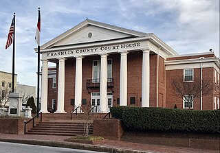
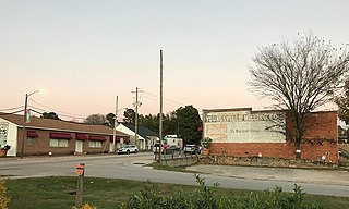
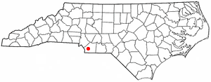
Franklin County is a county located in the U.S. state of North Carolina. As of the 2020 census, the population was 68,573. Its county seat is Louisburg.

<span class="mw-page-title-main">Franklin, Idaho</span> City in Idaho, United States

Franklin is a city in Franklin County, Idaho, United States. The population was 641 at the 2010 census. It is part of the Logan, Utah-Idaho Metropolitan Statistical Area.

<span class="mw-page-title-main">Claremont, North Carolina</span> City in North Carolina, United States

Claremont is a city in Catawba County, North Carolina, United States. The population was 1,352 at the 2010 census. It is part of the Hickory–Lenoir–Morganton Metropolitan Statistical Area.

<span class="mw-page-title-main">Mooresboro, North Carolina</span> Town in North Carolina, United States

Mooresboro is a town in Cleveland County, North Carolina, United States. The population was 311 at the 2010 census.

Boardman is a town in Columbus County, North Carolina, United States. Per the 2020 census, the population was 166.

<span class="mw-page-title-main">Dover, North Carolina</span> Town in North Carolina, United States

Dover is a town in Craven County, North Carolina, United States. The population was 401 at the 2010 Census. It is part of the New Bern, North Carolina Metropolitan Statistical Area.

<span class="mw-page-title-main">Franklinton, North Carolina</span> Town in North Carolina, United States

Franklinton is a town in Franklin County, North Carolina, United States. The population was 2,456 at the 2020 census.

<span class="mw-page-title-main">Louisburg, North Carolina</span> Town in North Carolina, United States

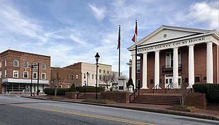
Louisburg is a town and the county seat of Franklin County, North Carolina, United States. As of the 2020 census, the town population was 3,064. The town is located approximately 29 miles northeast of the state capital, Raleigh, and located about 31 miles south of the Virginia border. It is also the home of Louisburg College, the oldest two-year coeducational college in the United States.

<span class="mw-page-title-main">Youngsville, North Carolina</span> Town in North Carolina, United States

Youngsville is a town in Franklin County, North Carolina, United States. The population was 2,016 at the 2020 census.

Orrum is a town in Robeson County, North Carolina, United States. The population was 91 at the 2010 census.

<span class="mw-page-title-main">Garland, North Carolina</span> Town in North Carolina, United States

Garland is a town in Sampson County, North Carolina, United States. The population was 595 at the 2020 census.

<span class="mw-page-title-main">Dobson, North Carolina</span> Town in North Carolina, United States

Dobson is a town in Dobson Township, Surry County, North Carolina, United States. As of the 2020 census, the town population was 1,396. It is the county seat of Surry County. Dobson is the home of the Shelton Vineyards, the largest winery in North Carolina. It is also home to a significant Latino population due to the large number of farms in the area. The main crops in the area are corn, tobacco and soy beans.

<span class="mw-page-title-main">Mineral Springs, North Carolina</span> Town in North Carolina, United States

Mineral Springs is a town in Union County, North Carolina, United States. The population was 2,639 at the 2010 census.

<span class="mw-page-title-main">Franklin Township, Greene County, Pennsylvania</span> Township in Pennsylvania, United States

Franklin Township is a township in Greene County, Pennsylvania, United States. The population was 7,062 at the 2020 census, down from 7,280 at the 2010 census.

<span class="mw-page-title-main">Fairfield Township, Westmoreland County, Pennsylvania</span> Township in Pennsylvania, United States

Fairfield Township is a township in Westmoreland County, Pennsylvania, United States. The population was 2,051 at the 2020 census.

<span class="mw-page-title-main">Bonneau, South Carolina</span> Town in South Carolina, United States

Bonneau is a town in Berkeley County, South Carolina, United States. The population was 487 at the 2010 census. It is part of the Charleston–North Charleston–Summerville Metropolitan Statistical Area.

<span class="mw-page-title-main">Boones Mill, Virginia</span> Town in Virginia, United States

Boones Mill is a town in Franklin County, Virginia, United States. The population was 239 in 2018, down from 285 at the 2000 census.

<span class="mw-page-title-main">Troutdale, Virginia</span> Town in Virginia, United States

Troutdale is a town in Grayson County, Virginia, United States. The population was 140 at the 2020 census.

<span class="mw-page-title-main">Ridgeway, Virginia</span> Town in Virginia, United States

Ridgeway is a town in Henry County, Virginia, United States. The population was 742 at the 2010 census. It is part of the Martinsville Micropolitan Statistical Area. Martinsville Speedway, a NASCAR racetrack, is located between Ridgeway and the Martinsville city limits.

Lake Royale is a census-designated place (CDP) in southeastern Franklin County, North Carolina, United States. The population was 3,392 at the 2020 census.

References

  1. The Franklin Times, A century ago, Bunn was poised for faster growth by Maury York, July 24, 2013, Retrieved July 24, 2017.
  2. "ArcGIS REST Services Directory". United States Census Bureau. Retrieved September 20, 2022.
  3. 1 2 U.S. Geological Survey Geographic Names Information System: Bunn, North Carolina
  4. 1 2 3 "U.S. Census website". United States Census Bureau . Retrieved January 16, 2015.
  5. 1 2 "Geographic Identifiers: 2020 Census Summary File 1 (G001), Bunn town, North Carolina". American FactFinder. U.S. Census Bureau. Archived from the original on February 13, 2020. Retrieved February 18, 2022.
  6. Town of Bunn, Retrieved January 15, 2015.
  7. William S. Powell, The North Carolina Gazetteer: A Dictionary of Tar Heel Places, 1968, The University of North Carolina Press at Chapel Hill, ISBN   0-8078-1247-1, Library of Congress Catalog Card #28-25916, page 75. Retrieved January 15, 2015.
  8. "National Register Information System". National Register of Historic Places . National Park Service. July 9, 2010.
  9. "City and Town Population Totals: 2020-2023". United States Census Bureau. May 16, 2024. Retrieved May 16, 2024.
  10. "Census of Population and Housing". Census.gov. Retrieved June 4, 2015.
  11. "Explore Census Data". data.census.gov. Retrieved February 18, 2022.
  12. Town of Bunn (Town Government), Retrieved December 22, 2021.