Bura East Airport

Last updated

Bura East Airport
Summary
Airport type Public, Civilian
Owner Kenya Civil Aviation Authority
ServesBura, Kenya
Location Bura, Flag of Kenya.svg Kenya
Elevation  AMSL 344 ft / 105 m
Coordinates 01°11′06″S39°48′50″E / 1.18500°S 39.81389°E / -1.18500; 39.81389 (Bura East Airport)
Map
Kenya adm location map.svg
Airplane silhouette.svg
HKBR
Location of Bura East Airport in Kenya
Placement on map is approximate
Runways
Direction LengthSurface
ftm
17-353,2801,000Unpaved

Bura East Airport is an airport in Kenya.

Location

Bura East Airport ( IATA : n/a, ICAO : HKBR) is located in the town of Bura, Tana River County, in southeastern Kenya, close to the Indian Ocean coast and to the International border with Somalia.

Contents

Its location is approximately 340 kilometres (210 mi), by air, east of Nairobi International Airport, the country's largest civilian airport. [1] The geographic coordinates of this airport are:1° 11' 6.00"S, 39° 48' 50.00"E (Latitude: -1.185000; Longitude:39.813890).

Overview

Bura East Airport is a small airport that serves the town of Bura, Tana. At the moment, there is no scheduled airline service to Bura East Airport. Situated at 105 metres (344 ft) above sea level, [2] the airport has a single unpaved runway 17-35, length 1000 m.

Airlines and destinations

None at the moment.

See also

Related Research Articles

Wilson Airport Airport in Kenya

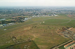
Wilson Airport is an airport in Nairobi, Kenya. It has flights to many regional airports in Kenya while Nairobi's main airport, Jomo Kenyatta International Airport, serves domestic and many international destinations.

Bura, Tana River County Place in Tana River County, Kenya


Bura is a town in Tana River County, Kenya.

The Mombasa–Garissa Road, also B8 Road (Kenya) is a major highway in Kenya, the largest economy in the East African Community. The road connects the port city of Mombasa to the inland city of Garissa. This road is composed of the Mombasa–Malindi Road and the Malindi–Garissa Road.

Bamburi Airport airport

Bamburi Airport is an airport in Kenya.

Bungoma Airport airport in Bungoma, Kenya

Bungoma Airport is an airport in Kenya.

Voi Airport Airport in Voi, Kenya

Voi Airport is an airport in Voi, Kenya.

Narok Airport airport in Narok, Kenya

Narok Airport is an airport in Narok, Kenya.

Naivasha Airport airport

Naivasha Airport is an airport in Naivasha, Kenya.

Mtito Andei Airport airport in Mtito Andei, Kenya

Mtito Andei Airport is an airport in Kenya.

Moyale Airport airport in Kenya

Moyale Airport, also referred to as Moyale Lower Airport, is an airport located in the town of Moyale, Marsabit County, in the northern part of the Republic of Kenya, at the international border with Ethiopia. Its location is approximately 590 kilometres (370 mi), by air, northeast of Nairobi International Airport, the country’s largest civilian airport. The geographic coordinates of this airport are:3° 27' 54.00"N, 39° 6' 18.00"E.

Garba Tula Airport airport in Garba Tula, Kenya

Garba Tula Airport is an airport in Kenya.

Garissa Airport airport

Garissa Airport is an airport in Kenya.

Hola Airport airport in Hola, Kenya

Hola Airport is an airport in Kenya.

Kalokol Airport airport in Kenya

Kalokol Airport, also named Fergusons Gulf Airport, is an airport located in Kalokol, a village in Turkana County in northwestern Kenya, on the western shores of Lake Turkana, close to the International border with Ethiopia.

Kisima Airport airport in Kenya

Kisima Airport is an airport in Kenya.

Kilaguni Airport airport in Kilaguni, Kenya

Kilaguni Airport is an airport in Kenya.

Makindu Airport airport in Makindu, Kenya

Makindu Airport is an airport in Makindu, Kenya.

Loitokitok Airstrip airport in Loitokitok, Kenya

Loitokitok Airstrip is an airstrip in Loitokitok, Kenya.

Mackinnon Road Airport airport in Mackinnon Road, Kenya

Mackinnon Road Airport is an airport in Mackinnon Road, Kenya.

Lamu–Garissa–Isiolo Road

Lamu-Garissa-Isiolo Road, is a road in Kenya, and is part of the Lamu-Garissa-Isiolo-Lokichar Road, which itself is a component of the Lamu Port and Lamu-Southern Sudan-Ethiopia Transport Corridor (LAPSSET) Project.

References

  1. "Distance between Bura (Coast) and Jomo Kenyatta Airport Nairobi (Nairobi Area) (Kenya)". distancecalculator.globefeed.com. Retrieved 21 August 2018.
  2. Elevation of Bura East Airport

Coordinates: 1°11′06″S39°48′50″E / 1.185000°S 39.813890°E / -1.185000; 39.813890