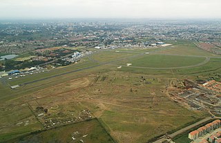
Mackinnon Road Airport

Last updated
Mackinnon Road Airport
Summary
Airport type Public, Civilian
Owner Kenya Airports Authority
ServesMackinnon Road, Kenya
Location Mackinnon Road, Flag of Kenya.svg  Kenya
Elevation  AMSL 1,181 ft / 360 m
Coordinates 03°44′00″S39°02′42″E / 3.73333°S 39.04500°E / -3.73333; 39.04500 (Mackinnon Road Airport)
Map
Kenya adm location map.svg
Airplane silhouette.svg
HKMR
Location of Mackinnon Road Airport in Kenya
Placement on map is approximate
Runways
Direction LengthSurface
ftm
12/303,7071,130Unpaved

Mackinnon Road Airport is an airport in Mackinnon Road, Kenya.

Contents

Location

Mackinnon Road Airport ( IATA : n/a, ICAO : HKMR) is located in Taita-Taveta County, in the town of Mackinnon Road, in southeastern Kenya, close to the International border with the Republic of Tanzania and to the eastern coast of Kenya, on the shores of the Indian Ocean. The airport lies just below the southern tip of Tsavo East National Park.

Its location is approximately 357 kilometres (222 mi), by air, southeast of Nairobi International Airport, the country's largest civilian airport. [1] Makinnon Road Airport is located approximately 70 kilometres (43 mi), by air, northwest of Moi International Airport, the nearest International Airport. [2] The geographic coordinates of this airport are:3° 44' 0.00"S, 39° 2' 42.00"E (Latitude:-3.733334; Longitude:39.045000).

Overview

Mackinnon Road Airport is a small airport that serves the town of Mackinnon Road and the adjacent Tsavo National Park. Situated at 1,181 feet (360 m) above sea level, the airport has a single unpaved runway that is 3,707 feet (1,130 m) long and 98 feet (30 m) wide. [3]

Airlines and destinations

At the moment there are no regular, scheduled airline services to Mackinnon Road Airport.

See also

Related Research Articles

Wilson Airport Airport in Kenya

Wilson Airport is an airport in Nairobi, Kenya. It has flights to many regional airports in Kenya while Nairobi's main airport, Jomo Kenyatta International Airport, serves domestic and many international destinations.

Manda Airport Airport in Kenya

Manda Airport, also called Lamu Airport, is an airport in Kenya.
Amboseli Airport airport in Kajiado County, Kenya

Amboseli Airport is an airport in Kenya.

Nanyuki Airport

Nanyuki Airfield is an airport in Nanyuki, Kenya.

Mulika Lodge Airport Airport in Kenya

Mulika Lodge Airport is an airport in Meru National Park, Kenya.

Kiwayu Airport

Kiwayu Airport is an airport serving Kiwayu, a small island in the eastern part of the Lamu Archipelago off the coast of Kenya. The airstrip is located on the mainland, adjacent to the northern tip of Kiwayu Island. This location lies in Lamu District, Coast Province, on the western shores of the Indian Ocean.

Bamburi Airport

Bamburi Airport is an airport in Kenya.

Voi Airport Airport in Voi, Kenya

Voi Airport is an airport in Voi, Kenya.

Nyeri Airport

Nyeri Airport is an airport in Nyeri Count, Kenya.

Naivasha Airport

Naivasha Airport is an airport in Naivasha, Kenya.

Mtito Andei Airport

Mtito Andei Airport is an airport in Kenya.

Hola Airport

Hola Airport is an airport in Kenya.

Kericho Airport

Kericho Airport is an airport in Kenya.

Kisima Airport

Kisima Airport is an airport in Kenya.

Mandera Airport

Mandera Airport is an airport in Mandera, Kenya.

Kilaguni Airport

Kilaguni Airport is an airport in Kenya.

Makindu Airport

Makindu Airport is an airport in Makindu, Kenya.

Kimwarer Airport

Kimwarer Airport is an airport in Kenya.

Lodwar Airport

Lodwar Airport is an airport in Kenya.

Lokitaung Airport

Lokitaung Airport is an airport in Lokitaung, Kenya.

References

  1. "Distance between Mackinnon Road (Coast) and Jomo Kenyatta Airport Nairobi (Nairobi Area) (Kenya)". distancecalculator.globefeed.com. Retrieved 2018-08-21.
  2. "Distance between Mackinnon Road (Coast) and Mombasa () (Airport) (Kenya)". distancecalculator.globefeed.com. Retrieved 2018-08-21.
  3. "IVAO - International Virtual Aviation Organization". www.ivao.aero. Retrieved 2018-08-21.

Coordinates: 3°44′00″S39°02′42″E / 3.733334°S 39.045000°E / -3.733334; 39.045000