Burbage Brook

Last updated

Burbage Brook
Burbage Brook in Padley Gorge (geograph 3716393).jpg
Burbage Brook in Padley Gorge
Derbyshire UK relief location map.jpg
Red pog.svg
Location of the mouth within Derbyshire
Location
Country England
Region Derbyshire
Physical characteristics
Source 
  location Derbyshire, England
Mouth  
  location
Derbyshire, England
  coordinates
53°18′10″N1°38′17″W / 53.302806°N 1.6380°W / 53.302806; -1.6380 Coordinates: 53°18′10″N1°38′17″W / 53.302806°N 1.6380°W / 53.302806; -1.6380

Burbage Brook is an upper tributary stream of the River Derwent in the Peak District of England.

Contents

Toponymy

The origin of the name is thought to derive from the Germanic baki for creek.

Course

White Path Moss

The source of the brook is on moorland to the north of the brook's valley in Derbyshire where it drains the land south of Friar's Ridge on White Path Moss, close to Stanage Edge.

Burbage Valley

Within the first kilometre the altitude of the brook falls just over 60 metres from 396 to 335 metres above sea level. [1] The water enters Burbage Valley and Sheffield at the Upper Burbage Bridge ( 53°19′21″N1°36′33″W / 53.32250°N 1.60917°W / 53.32250; -1.60917 ). It then flows through the Burbage valley and the remains of Burbage conifer plantation, which included Lodgepole pine, Scots pine and Japanese larch. This was planted by Sheffield City Council between 1968 and 1971 with an outline designed to represent Great Britain when viewed from the air. It was sometimes known as the Great Britain Plantation. The West Country was not represented by the plantation due to unexploded ordnance being found where the planting was to have taken place. This is a result of the area around the brook being used as a training ground by British Home Guard and Canadian infantry during World War II. Prior to the planting of trees the area was to have been the site of a reservoir, though this plan was rejected due to unsuitable underlying geology. The plantation was felled following recommendations made in Moors for the Future Report No 8 and on the recommendation of South Yorkshire Fire and Rescue service, with work to remove the trees commencing in August 2014. Parts of the Burbage Valley are a Site of Special Scientific Interest (SSSI) and are home to the water vole, which resulted in a decision to remove the felled trunks by helicopter in order to minimise the environmental impact of the wood's clearance. Stumps of the trees have not been uprooted as the Moors for the Future report suggested that the area covered by the plantation might contain important archaeological remains. [2] The seeds of native trees have been planted in some parts of the former plantation, with the seeds, including those of Sessile Oak, having been gathered from Clough Woodlands on the nearby Longshaw Estate. Work to remove the plantation, funded by the Nature Improvement Areas Programme, is expected to result in an additional area of 14.40 ha of native woodland and 8.58 ha of upland heath around the brook. [3] The valley is overlooked by Higger Tor and Carl Wark to the west and Burbage Rocks to the east, one of the birth places of modern British climbing. As it flows out of the remnants of the plantation, the brook passes under a Grade II listed packhorse bridge. [4]

Lawrence Field and Padley Gorge

It continues down the valley and below the A6187 at (lower) Burbage Bridge, close to a rock feature known as Toad's Mouth and the associated Toad's Mouth prehistoric field system, where it re-enters Derbyshire at Lawrence Field. [5] It then flows into Padley Gorge, Derbyshire, as it passes through the Longshaw Estate. The woodland around the brook, Yarncliff Wood, at this point is also a SSSI and a breeding site for pied flycatcher, wood warbler and hawfinch. [6] At Upper Padley, before it flows into the river Derwent, it flows close to Grindleford railway station and Padley Chapel.

Artistic representation

The brook, as seen from Upper Burbage Bridge was depicted in a painting by artist Stanley Royle in 1919, and again, this time from (lower) Burbage Bridge at an unknown date. [7] [8] [9]

See also

Related Research Articles

The Upper Derwent Valley is an area of the Peak District National Park in England. It largely lies in Derbyshire, but its north eastern area lies in Sheffield, South Yorkshire. Its most significant features are the Derwent Dams, Ladybower, Derwent and Howden, which form Ladybower Reservoir, Derwent Reservoir and Howden Reservoir respectively.

River Derwent, Derbyshire River in Derbyshire, England

The Derwent is a river in Derbyshire, England. It is 50 miles (80 km) long and is a tributary of the River Trent, which it joins south of Derby. Throughout its course, the river mostly flows through the Peak District and its foothills.

Derwent Reservoir (Derbyshire) Reservoir in Derbyshire, England

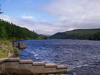
Derwent Reservoir is the middle of three reservoirs in the Upper Derwent Valley in the north of Derbyshire, England. It lies approximately 10 miles (16 km) from Glossop and 10 miles (16 km) from Sheffield. The River Derwent flows first through Howden Reservoir, then Derwent Reservoir and finally through Ladybower Reservoir. Between them they provide practically all of Derbyshire's water, as well as to a large part of South Yorkshire and as far afield as Nottingham and Leicester.

Upper Goyt Valley Valley in the Peak District of England

The Upper Goyt Valley is the southern section of the valley of the River Goyt in North West England.

The Moss

The Moss is a brook in North East Derbyshire, England.

Hope Valley, Derbyshire Valley in Derbyshire, England

The Hope Valley is a rural area centred on the village of Hope, Derbyshire, in the Peak District in the northern Midlands of England.

Grindleford Human settlement in England

Grindleford is a village and civil parish in the county of Derbyshire, in the East Midlands of England. The population of the civil parish as taken at the 2011 Census was 909. It lies at an altitude of 492 feet (150 m) in the valley of the River Derwent in the Peak District National Park. The 17th-century Grindleford Bridge crosses the river on the western side of the village. On the west side of the valley is the 1,407 feet (429 m) high Sir William Hill, and to the south-east lies the gritstone escarpment of Froggatt Edge. Grindleford became a parish in 1987, merging the parishes of Eyam Woodlands, Stoke, Nether Padley and Upper Padley.

Carl Wark

Carl Wark is a rocky promontory on Hathersage Moor in the Peak District National Park, just inside the boundary of Sheffield, England. The promontory is faced by vertical cliffs on all but one side, which is protected by a prehistoric embankment. The cliffs and embankment form an enclosure that has been interpreted as an Iron Age hill fort, though the date of construction and purpose of the fortifications remains unknown. The site is a scheduled monument.

Padley Gorge Valley in Derbyshire, England

Padley Gorge is a deep but narrow valley in the Peak District, Derbyshire between the village of Grindleford and the A6187 road.

Hathersage Road (Sheffield) Road in South Yorkshire and Derbyshire, England

Hathersage Road is a road in Sheffield South Yorkshire, England and Derbyshire. It leads south-west from the suburb of Whirlow over the border between Hathersage and Sheffield, before becoming Sheffield Road at the point called Surprise View. The road begins at a bridge on the Limb Brook, the former boundary between Yorkshire and Derbyshire. There the road changes name from Ecclesall Road South to Hathersage Road.

Derwent, Derbyshire Human settlement in England

Derwent was a village 'drowned' in 1944 when the Ladybower Reservoir in Derbyshire, England was created. The village of Ashopton, Derwent Woodlands church and Derwent Hall were also 'drowned' in the construction of the reservoir.

A6187 road


The A6187 is a secondary route in the Peak District, Derbyshire and South Yorkshire, England. It starts in Castleton, runs in an easterly direction past Fox House Inn where it joins the A625 road. It is 13.6 miles long.

Padley Hall Former Elizabethan manor house in Derbyshire, England

Padley Hall was an Elizabethan great house overlooking the River Derwent near Grindleford, Derbyshire, England. The remains of the hall today are mostly just foundation walls. The site is a protected Scheduled Monument. Not to be confused with 17th-century Padley Hall near Ripley.

Totley Moor Hill in the Derbyshire Peak District

Totley Moor is an open moorland hill to the west of the Sheffield suburb of Totley, in the Derbyshire Peak District. The summit is 395 metres (1,296 ft) above sea level.

Cats Tor Hill in Cheshire, England

Cats Tor is a Peak District hill on the border between Cheshire and Derbyshire, between the towns of Macclesfield and Buxton. The summit is 518 metres (1,699 ft) above sea level. Tor is an Old English word for a high, rocky hill.

Vale of Edale Valley in the Peak District of England

The Vale of Edale is the upper valley of the River Noe, in the Derbyshire Peak District of England. The village of Edale lies in the middle of the valley.

The Robin Brook is a small stream originating in the south eastern part of the City of Sheffield in South Yorkshire, England. The source of the stream is in the Charnock area of the city, where it flows south, crossing the border into Derbyshire. It meets The Moss at Ford.

References

  1. Fact Sheet Archived 30 October 2008 at the Wayback Machine , Peak District Education, accessed 1 January 2009
  2. Bevan, Bill (2006). "From Cairns to Craters: Conservation Heritage Assessment of Burbage" (PDF). Moors for the Future. Archived from the original (PDF) on 4 March 2016. Retrieved 7 December 2017.
  3. Talbot, Ted (2015). "Transforming the Burbage Valley" (PDF). assets.publishing.service.gov.uk. Retrieved 4 February 2019.
  4. Historic England. "PACKHORSE BRIDGE APPROXIMATELY 850 METRES NORTH OF BURBAGE BROOK, Sheffield (1255107)". National Heritage List for England . Retrieved 7 December 2017.
  5. Historic England. "Toad's Mouth prehistoric field system, Sheffield (1017507)". National Heritage List for England . Retrieved 4 February 2019.
  6. "Yarncliffe Wood SSSI notification" (PDF). designatedsites.naturalengland.org.uk. 14 July 1986. Retrieved 4 February 2019.
  7. "Burbage Brook". Art UK. Retrieved 7 December 2017.
  8. "Museums Sheffield: From Yorkshire Hills to Derbyshire Hills". collections.museums-sheffield.org.uk. Retrieved 4 February 2019.
  9. "Museums Sheffield: Burbage, Derbyshire". collections.museums-sheffield.org.uk. Retrieved 4 February 2019.

Commons-logo.svg Media related to Burbage Brook at Wikimedia Commons