Burghead Fort

Last updated

Burghead Fort
Roy - Burghead fort.jpg
Plan of the remains of the fort drawn by General William Roy in 1793
Scotland relief location map.jpg
Archaeological site icon (red).svg
Burghead Fort
Shown within Scotland
Coordinates 57°42′13″N3°29′50″W / 57.7036°N 3.4971°W / 57.7036; -3.4971 Coordinates: 57°42′13″N3°29′50″W / 57.7036°N 3.4971°W / 57.7036; -3.4971
Type Promontory fort
Length1,000 feet (300 m)
Width600 feet (180 m)
Area12.4 acres (5.0 ha)
History
Periods Iron Age, Pictish

Burghead Fort was a Pictish promontory fort on the site now occupied by the small town of Burghead in Moray, Scotland. It was one of the earliest power centres of the Picts [1] and was three times the size of any other enclosed site in Early Medieval Scotland. [2] The fort was probably the main centre of the Pictish Kingdom of Fortriu, flourishing like the kingdom itself from the 4th to the 9th centuries. [2]

Contents

Burghead is not recorded in any surviving annals [3] and its name in the Pictish language is not recorded, [4] but it may be the Pinnata Castra that features in Ptolemy's 2nd century Geography . [3] The original defences may date from the Iron Age, but were substantially rebuilt during the early historic period. [5]

The remains of the fort were largely destroyed when the harbour and town of Burghead were remodelled in the early 19th century, but its layout is recorded in a plan drawn by William Roy in 1793. [6] Sections of its inner ramparts still stand up to 9.8 feet (3.0 m) high, [4] and a small section of the innermost outer rampart survives as the "Doorie Hill". [7] The fort's underground ritual well can be visited and the site has a visitor centre where important Pictish sculpture from the fort can be seen. [8]

Layout and construction

The site consisted of a walled inner enclosure measuring 1,000 feet (300 m) in length and 600 feet (180 m) in width, which was divided into two wards or courts: a smaller, higher enclosure or citadel to the southwest, and a larger, lower one to the northeast. [9] In total the enclosure occupied an area of 12.4 acres (5.0 ha) [4] Cutting off the enclosure and the headland was a system of three ramparts and ditches, together measuring 800 feet (240 m) by 180 feet (55 m), with each cut by entrances mid-way along. [9] These were constructed of earth and rubble. [10] Excavation on the 1890s revealed a paved roadway through the fort. [7]

The western wall of the upper enclosure was excavated in 1969 and found to be exceptionally massive, with an 8 metres (26 ft) thick base and a surviving height of 3 metres (9.8 ft). [6] The wall would originally have been even more formidable, [11] up to 6 metres (20 ft) high. [12] and possibly topped by a wooden superstructure. [3] It was constructed with stone revetments at the front and back around an internal framework of transverse and longitudinal timbers, [6] with the centre of the structure filled with stone rubble and rolled pebbles. [7] The ramparts were constructed on foundations made of layers of oak laid upon sand, [7] and the oak beams of the timber framework almost certainly protruded from the sandstone walls. [12] The stone ramparts of the lower enclosure were also built around a timber framework, but these were held together by giant iron spikes - an exceptional construction technique unrelated to earlier British Iron Age building traditions, instead of being associated with the Murus Gallicus structures of the late La Tene fortifications of continental Europe. [6]

History and use

Remaining ramparts of the lower enclosure Lower part of Pictish fort grounds - geograph.org.uk - 983879.jpg
Remaining ramparts of the lower enclosure

The fort was built in multiple phases. [7] Radiocarbon dating has demonstrated that the main walls were constructed in the early historic period, possibly as early as the late 3rd century, and they were refurbished in the 6th or 7th centuries. [12] The layout of the fort was typical of those built across Britain and France in the late Iron Age, though, suggesting that the Picts may have reoccupied an earlier stronghold and reinforced it by adding the stone fortifications. [12] Differences in the techniques used to build the walls of the upper and lower enclosures suggest different dates of construction, and the triple ramparts and ditches that cut the enclosure off from the mainland may predate the main body of the fort and represent earlier Iron Age defences. [6] Signs of earlier occupation found on the site of the fort include a Late Bronze Age spearhead, a Greek coin of the reign of Nero (54–68 AD), [9] and a Celtic stone head found within the well. [13] Indications of non-domestic occupation have been found from the Iron Age, Norse and Early Medieval periods, [9] but no sign of occupancy of the fort survives after the 9th century, a period approximately coinciding with entries in the Annals of Ulster recording devastating Norse raids on the Kingdom of Fortriu. [12]

The two enclosures of the main fort had separate entrances, with no evidence of any internal gateway between them, implying a hierarchical relationship between them. [14] The higher section of the main fort to the west may have formed a high-status enclosure including a royal hall and dwelling, with the larger enclosure to the north east containing a settlement. [12] The higher enclosure would also have included buildings housing the ruler's retinue and others supplying the royal court with its needs. [15] The foundation stones of buildings have been found within the lower enclosure [7] and there is archaeological evidence of livestock being kept within the outer walls of the fort. [15] The site's importance and its excellent nearby anchorage makes it likely that it was an important base for the Pict's naval forces, which are recorded as significant between the 4th and the 8th centuries. [16]

The fort had religious as well as secular importance. [12] The bull carvings found on the site in the 19th century have been seen as evidence for a surviving pagan bull cult, and the underground well in its rock-cut chamber as the centre of a pagan water cult, [17] a possibility reinforced by the Celtic stone head that was discovered in the well in the 19th century. [13] The Burning of the Clavie, which still takes place in Burghead annually, has also been seen as a surviving pagan fire festival. [17] There is archaeological evidence of a chapel within the fort by the 8th century, [18] and decorated stones dating from around AD 800 found in Burghead churchyard were probably the remains of Christian crosses. [12] Fragments of an early Christian shrine have been discovered immediately outside the fort, [19] and the secular power centre of the fort may have had a significant relationship with the major Pictish religious centres of Kinneddar, located 8 miles (13 km) to the east, [19] and Portmahomack, which is just visible from Burghead on the opposite side of the Moray Firth. [20]

The Burghead Bulls

One of the Burghead Bulls on display at the British Museum Britishmuseumburgheadbull.jpg
One of the Burghead Bulls on display at the British Museum

During the destruction of the site in the early 19th century up to thirty stone panels carrying carved images of bulls were discovered. [4] Although most of these were built into the quay wall of Burghead Harbour and were lost, [4] six remain: two in the visitor centre in Burghead itself, two in Elgin Museum, one in the National Museum of Scotland in Edinburgh and one in the British Museum in London. [21] The Bulls have been dated to the 5th century or later and may have formed a frieze set into the ramparts of the fort, [4] possibly forming part of a warrior cult celebrating strength and aggression. [22]

The degree of naturalism of the Burghead Bulls is unequalled in early Medieval art, [22] and the carvings testify to the site's exceptional importance and suggest it may have been an important Royal centre in the early historic period. [6]

Related Research Articles

Picts Ancient and medieval tribal confederation in northern Britain

The Picts were a group of peoples who lived in what is now northern and eastern Scotland during Late Antiquity and the Early Middle Ages. Where they lived and what their culture was like can be inferred from early medieval texts and Pictish stones. Their Latin name, Picti, appears in written records from the 3rd to the 10th century. Early medieval sources report the existence of a distinct Pictish language, which today is believed to have been an Insular Celtic language, closely related to the Brittonic spoken by the Britons who lived to the south.

Burghead Human settlement in Scotland

Burghead is a small town in Moray, Scotland, about 8 miles (13 km) north-west of Elgin. The town is mainly built on a peninsula that projects north-westward into the Moray Firth, surrounding it by water on three sides. People from Burghead are called Brochers.

Brough of Birsay An uninhabited tidal island off the north-west coast of The Mainland of Orkney, Scotland

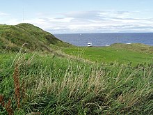
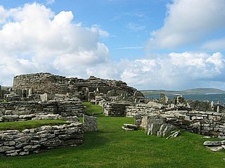
The Brough of Birsay is an uninhabited tidal island off the north-west coast of The Mainland of Orkney, Scotland, in the parish of Birsay. It is located around 13 miles north of Stromness and features the remains of Pictish and Norse settlements as well as a modern light house.

Pictish stone Monuments erected by early Scottish tribes

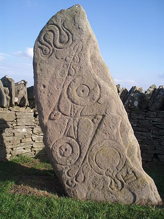
A Pictish stone is a type of monumental stele, generally carved or incised with symbols or designs. A few have ogham inscriptions. Located in Scotland, mostly north of the Clyde-Forth line and on the Eastern side of the country, these stones are the most visible remaining evidence of the Picts and are thought to date from the 6th to 9th century, a period during which the Picts became Christianized. The earlier stones have no parallels from the rest of the British Isles, but the later forms are variations within a wider Insular tradition of monumental stones such as high crosses. About 350 objects classified as Pictish stones have survived, the earlier examples of which holding by far the greatest number of surviving examples of the mysterious symbols, which have long intrigued scholars.

Portmahomack is a small fishing village in Easter Ross, Scotland. It is situated in the Tarbat Peninsula in the parish of Tarbat. Tarbat Ness Lighthouse is about three miles from the village at the end of the Tarbat Peninsula. Ballone Castle lies about one mile from the village. There is evidence of early settlement, and the area seems to have been the site of significant activity during the time of the Picts, early Christianity and the Vikings. The village is situated on a sandy bay and has a small harbour designed by Thomas Telford: it shares with Hunstanton the unusual distinction of being on the east coast but facing west. Portmahomack lies inside the Moray Firth Special Area of Conservation with the associated dolphin and whale watching activity.

Suenos Stone Large ancient stone marker in Scotland

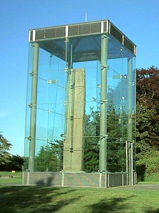
Sueno's Stone is a Picto-Scottish Class III standing stone on the north-easterly edge of Forres in Moray and is the largest surviving Pictish style cross-slab stone of its type in Scotland, standing 6.5 metres in height. It is situated on a raised bank on a now isolated section of the former road to Findhorn. The stone is named after Sweyn Forkbeard, but this association has been challenged and it has also been associated with the killing of King Dubh mac Ailpin in Forres in 966. The stone was erected c. 850–950 but by whom and for what, is unknown.

Moray was a province within the area of modern-day Scotland, that may at times up to the 12th century have operated as an independent kingdom or as a powerbase for competing claimants to the Kingdom of Alba. It covered a different and much larger territory than the modern council area of Moray, extending approximately from the River Spey in the east to the River Beauly in the north, and encompassing Badenoch, Lochaber and Glenelg in the south and west.

Fortriu Pictish kingdom in Scotland, 4th-10th centuries

Fortriu was a Pictish kingdom that existed between the 4th and 10th centuries. It was traditionally believed to be located in and around Strathearn in central Scotland, but is more likely to have been based in the north, in the Moray and Easter Ross area. Fortriu is a term used by historians as it is not known what name its people used to refer to their polity. Historians also sometimes use the name synonymously with Pictland in general.

Duffus

Duffus is a village and parish in Moray, Scotland.

Scotland in the Early Middle Ages Overview of Scotland in the Early Middle Ages

Scotland was divided into a series of kingdoms in the early Middle Ages, i.e. between the end of Roman authority in southern and central Britain from around 400 CE and the rise of the kingdom of Alba in 900 CE. Of these, the four most important to emerge were the Picts, the Gaels of Dál Riata, the Britons of Alt Clut, and the Anglian kingdom of Bernicia. After the arrival of the Vikings in the late 8th century, Scandinavian rulers and colonies were established on the islands and along parts of the coasts. In the 9th century, the House of Alpin combined the lands of the Scots and Picts to form a single kingdom which constituted the basis of the kingdom of Scotland.

Broch of Gurness

The Broch of Gurness is an Iron Age broch village on the northeast coast of Mainland Orkney in Scotland overlooking Eynhallow Sound, about 15 miles north-west of Kirkwall. It once housed a substantial community.

Scotland during the Roman Empire Aspect of Scottish history

Scotland during the Roman Empire refers to the protohistorical period during which the Roman Empire interacted with the area that is now Scotland. Despite sporadic attempts at conquest and government between the 1st and 4th centuries AD, most of modern Scotland, inhabited by the Caledonians and the Maeatae, was not incorporated into the Roman Empire.

Kinneddar

Kinneddar is a small settlement on the outskirts of Lossiemouth in Moray, Scotland, near the main entrance to RAF Lossiemouth. Long predating the modern town of Lossiemouth, Kinneddar was a major monastic centre for the Pictish kingdom of Fortriu from the 6th or 7th centuries, and the source of the important collection of Pictish stones called the Drainie Carved Stones. The Kirk of Kinneddar was the cathedral of the Diocese of Moray between 1187 and 1208, and remained an important centre of diocesan administration and residence of the Bishop of Moray through the 13th and 14th centuries.

Clatchard Craig

The fort of Clatchard Craig was located on a hill of the same name by the Tay. A human presence on the site has been identified from the neolithic period onward and the fort itself was occupied from the sixth century AD until at least the eighth century. It stood close to several places which were centres of secular and religious power during the early Middle Ages including Abernethy, Forteviot, Scone and Moncreiffe. As such it seems to have been an important stronghold of the Picts.

Hillforts in Scotland Earthworks on hilltops

Hillforts in Scotland are earthworks, sometimes with wooden or stone enclosures, built on higher ground, which usually include a significant settlement, built within the modern boundaries of Scotland. They were first studied in the eighteenth century and the first serious field research was undertaken in the nineteenth century. In the twentieth century there were large numbers of archaeological investigations of specific sites, with an emphasis on establishing a chronology of the forts. Forts have been classified by type and their military and ritual functions have been debated.

Burghead Bulls

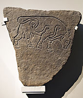
The Burghead Bulls are a group of carved Pictish stones from the site of Burghead Fort in Moray, Scotland, each featuring an incised image of a bull. Up to 30 were discovered during the demolition of the fort to create the town of Burghead in the 19th century, but most were lost when they were used to build the harbour quayside. Six remain: two in the Visitor Centre in Burghead, two in Elgin Museum, one in the National Museum of Scotland in Edinburgh, and one in the British Museum in London.

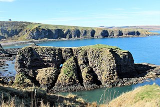
Green Castle is a naturally defended rocky outcrop in the village of Portknockie in Moray, Scotland, that was occupied successively by small promontory forts of the Iron Age and Pictish periods.

Knock of Alves

The Knock of Alves is a small wooded hill that lies 3 miles (4.8 km) to the west of Elgin in Moray, Scotland, rising to 335 feet (102 m) above ordnance datum. Its summit is marked by York Tower, a 3-storey octagonal folly erected in 1827 to commemorate Prince Frederick, the Duke of York; and the Forteath Mausoleum, built in 1850 as the burial place of 7 members of the Forteath family of the nearby house of Newton.

Dunnicaer Sea stack and remains of Pictish hill fort in Aberdeenshire, Scotland

Dunnicaer, or Dun-na-caer, is a precipitous sea stack just off the coast of Aberdeenshire, Scotland, between Dunnottar Castle and Stonehaven. Despite the unusual difficulty of access, in 1832 Pictish symbol stones were found on the summit and 21st-century archaeology has discovered evidence of a Pictish hill fort which may have incorporated the stones in its structure. The stones may have been incised in the third or fourth centuries AD but this goes against the general archaeological view that the simplest and earliest symbol stones date from the fifth or even seventh century AD.

Sculptors Cave

The Sculptor's Cave is a sandstone cave on the south shore of the Moray Firth in Scotland, near the small settlement of Covesea, between Burghead and Lossiemouth in Moray. It is named after the Pictish carvings incised on the walls of the cave near its entrances. There are seven groups of carvings dating from the 6th or 7th century, including fish, crescent and V-rod, pentacle, triple oval, step, rectangle, disc and rectangle, flower, and mirror patterns, some very basic but others more sophisticated.

References

  1. Foster 2014, p. 46.
  2. 1 2 Fraser 2009, p. 51.
  3. 1 2 3 Foster 2014, p. 47.
  4. 1 2 3 4 5 6 Driscoll 2007, p. 58.
  5. Konstam 2010, pp. 21–22.
  6. 1 2 3 4 5 6 Harding, Dennis (2012). Iron Age Hillforts in Britain and Beyond. Oxford: Oxford University Press. pp. 171–172. ISBN   978-0199695249 . Retrieved 12 September 2015.
  7. 1 2 3 4 5 6 "Burghead Fort". Moray Sites and Monuments Record. Aberdeenshire Council. Archived from the original on 31 August 2015. Retrieved 12 September 2015.
  8. Foster 2014, p. 160.
  9. 1 2 3 4 "Burghead". Canmore. Royal Commission on the Ancient and Historical Monuments of Scotland. Retrieved 12 September 2015.
  10. Foster 2014, pp. 46–47.
  11. Konstam 2010, p. 42.
  12. 1 2 3 4 5 6 7 8 Konstam 2010, p. 22.
  13. 1 2 Foster 2014, pp. 51–52.
  14. Konstam 2010, p. 55.
  15. 1 2 Konstam 2010, p. 49.
  16. Foster 2014, pp. 47, 137.
  17. 1 2 Laing, Lloyd Robert (2006). The Archaeology of Celtic Britain and Ireland: C.AD 400 - 1200. Cambridge: Cambridge University Press. p. 29. ISBN   9780521838627 . Retrieved 12 September 2015.
  18. Fraser 2009, p. 87.
  19. 1 2 Foster 2014, p. 52.
  20. Foster 2014, p. 122.
  21. "Burghead Well". Places to visit. Historic Environment Scotland. Retrieved 12 September 2015.
  22. 1 2 "The Burghead Bull". The British Museum. Retrieved 12 September 2015.

Bibliography