
Albay, officially the Province of Albay, is a province in the Bicol Region of the Philippines, mostly on the southeastern part of the island of Luzon. Its capital is the city of Legazpi, the regional center of the whole Bicol Region, which is located in the southern foothill of Mayon Volcano.

Sorsogon, officially the Province of Sorsogon, is a province in the Philippines located in the Bicol Region. It is the southernmost province in Luzon and is subdivided into fourteen municipalities (towns) and one city. Its capital is Sorsogon City and borders the province of Albay to the north.
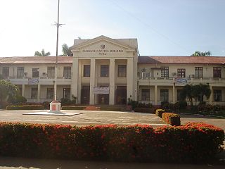
Masbate, officially the Province of Masbate, is an island province in the Philippines located near the midsection of the nation's archipelago. Its provincial capital is Masbate City. The province consists of three major islands: Masbate, Ticao and Burias.
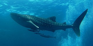
The whale shark is a slow-moving, filter-feeding carpet shark and the largest known extant fish species. The largest confirmed individual had a length of 18.8 m (61.7 ft). The whale shark holds many records for size in the animal kingdom, most notably being by far the largest living nonmammalian vertebrate. It is the sole member of the genus Rhincodon and the only extant member of the family Rhincodontidae, which belongs to the subclass Elasmobranchii in the class Chondrichthyes. Before 1984 it was classified as Rhiniodon into Rhinodontidae.
Ticao Island, is an island with a total land area of 334 km2 or 129 sq mi. It is one of the three major islands of Masbate province in the Philippines. It is separated from the Bicol Peninsula by the Ticao Pass. The other two major islands are Masbate Island and Burias Island.

Masbate Island is the largest of three major islands of Masbate Province in the Philippines. The other two major islands are Ticao Island and Burias Island. It is the 11th-largest island in both area and population in the Philippines and the world's 155th largest island by area and the world's 70th most populous island. The island is divided into 14 municipalities and 1 city, and has a total population of 731,269 people as of 2020 census. Masbate City is the island largest settlement with a total population of 104,522 as of 2020.
Burias Island is one of the three major islands of Masbate province in the Philippines. It is separated from the Bicol Peninsula by the Burias Pass. The other two major islands are Ticao Island and Masbate Island. The Island has two municipalities, Claveria and San Pascual.
Masbate City, officially known as the City of Masbate, is a 4th class component city and capital of the province of Masbate, Philippines. According to the 2020 census, it has a population of 104,522 people.
Libon, officially the Municipality of Libon, is a 1st class municipality in the province of Albay, Philippines. According to the 2020 census, it has a population of 75,073 people.

Donsol, officially the Municipality of Donsol, is a 3rd class municipality in the province of Sorsogon, Philippines. According to the 2020 census, it has a population of 50,281 people.

Aroroy, officially the Municipality of Aroroy, is a 1st class municipality in the province of Masbate, Philippines. According to the 2020 census, it has a population of 88,351 people. The town is known for the Kalanay Cave, one of the most important archaeological sites in Masbate province.

Batuan, officially the Municipality of Batuan, is a 5th class municipality in the province of Masbate, Philippines. According to the 2020 census, it has a population of 14,610 people.

Monreal, officially the Municipality of Monreal, is a 4th class municipality in the province of Masbate, Philippines. According to the 2020 census, it has a population of 25,164 people.

San Fernando, officially the Municipality of San Fernando, is a 5th class municipality in the province of Masbate, Philippines. According to the 2020 census, it has a population of 21,600 people.

San Jacinto, officially the Municipality of San Jacinto, is a 4th class municipality in the province of Masbate, Philippines. According to the 2020 census, it has a population of 29,686 people.

The Samar Sea is a small sea within the Philippine archipelago, situated between the Bicol Region of Luzon and the Eastern Visayas.

Shark tourism is a form of eco-tourism that allows people to dive with sharks in their natural environment. This benefits local shark populations by educating tourists and through funds raised by the shark tourism industry. Communities that previously relied on shark finning to make their livelihoods are able to make a larger profit from diving tours while protecting the local environment. People can get close to the sharks by free- or scuba diving or by entering the water in a protective cage for more aggressive species. Many of these dives are done by private companies and are often baited to ensure shark sightings, a practice which is highly controversial and under review in many areas.

Apo Reef is a coral reef system in the Philippines situated in the western waters of Occidental Mindoro province in the Mindoro Strait. Encompassing 34 square kilometres (13 sq mi), it is considered the world's second-largest contiguous coral reef system, and is the largest in the country. The reef and its surrounding waters are protected areas administered as the Apo Reef Natural Park (ARNP). It is one of the best known and most popular diving regions in the country, and is in the tentative list for UNESCO World Heritage Sites.
Bongsanglay Natural Park is a protected area of mangrove forests and swamps on Ticao Island in the Bicol Region of the Philippines. It is located in the municipality of Batuan in the island province of Masbate covering an area of 244.72 hectares. The protected area was established on 29 December 1981 when the area "from Panciscan Point in Bitos Bay up to Bano Sanlay" in Batuan was declared a Mangrove Swamp Forest Reserve under Proclamation No. 2152 signed by President Ferdinand Marcos. In 2000, when President Joseph Estrada signed Proclamation No. 319, Bongsanglay was reclassified as a natural park pursuant to the National Integrated Protected Areas System (NIPAS) Act.

Ticao Pass is the strait that separates Ticao Island from the Bicol Peninsula in the Philippines. It connects the Burias Pass in the north with the Samar Sea in the south.


