The Arabian Peninsula, or Arabia, is a peninsula in West Asia, situated northeast of Africa on the Arabian Plate. At 3,237,500 km2 (1,250,000 sq mi), comparable in size to India, the Arabian Peninsula is the largest peninsula in the world.
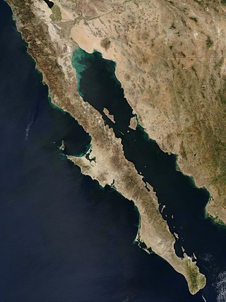
The Baja California peninsula is a peninsula in northwestern Mexico. It separates the Gulf of California from the Pacific Ocean. The peninsula extends from Mexicali, Baja California, in the north to Cabo San Lucas, Baja California Sur, in the south.

An isthmus is a narrow piece of land connecting two larger areas across an expanse of water by which they are otherwise separated. A tombolo is an isthmus that consists of a spit or bar, and a strait is the sea counterpart of an isthmus, a narrow stretch of sea between two landmasses that connects two larger bodies of water.

The Cooperation Council for the Arab States of the Gulf, also known as the Gulf Cooperation Council, is a regional, intergovernmental, political, and economic union comprising Bahrain, Kuwait, Oman, Qatar, Saudi Arabia, and the United Arab Emirates. The council's main headquarters is located in Riyadh, the capital of Saudi Arabia. The Charter of the GCC was signed on 25 May 1981, formally establishing the institution.
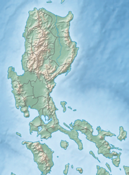
The Moro Gulf is the largest gulf in the Philippines. It is located off the coast of Mindanao Island, and is part of the Celebes Sea. The gulf is one of the country's tuna fishing grounds.

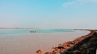
The Gulf of Suez is a gulf at the northern end of the Red Sea, to the west of the Sinai Peninsula. Situated to the east of the Sinai Peninsula is the smaller Gulf of Aqaba. The gulf was formed within a relatively young but now inactive Gulf of Suez Rift rift basin, dating back about 26 million years. It stretches some 300 kilometres (190 mi) north by northwest, terminating at the Egyptian city of Suez and the entrance to the Suez Canal. Along the mid-line of the gulf is the boundary between Africa and Asia. The entrance of the gulf lies atop the mature Gemsa oil and gas field. The gulf is considered one of the world's important maritime zones due to being an entrance to the Suez Canal.

The Gulf of Aqaba or Gulf of Eilat is a large gulf at the northern tip of the Red Sea, east of the Sinai Peninsula and west of the Arabian Peninsula. Its coastline is divided among four countries: Egypt, Israel, Jordan, and Saudi Arabia. The northernmost coral reef in the world is situated near the Eilat shore.

The Spencer Gulf is the westernmost and larger of two large inlets on the southern coast of Australia, in the state of South Australia, facing the Great Australian Bight. It spans from the Cape Catastrophe and Eyre Peninsula in the west to Cape Spencer and Yorke Peninsula in the east.

Chalkidiki, also known as Chalcidice, is a peninsula and regional unit of Greece, part of the region of Central Macedonia, in the geographic region of Macedonia in Northern Greece. The autonomous Mount Athos region constitutes the easternmost part of the peninsula, but not of the regional unit.

The Gulf of Carpentaria is a sea off the northern coast of Australia. It is enclosed on three sides by northern Australia and bounded on the north by the eastern Arafura Sea, which separates Australia and New Guinea. The northern boundary is generally defined as a line from Slade Point, Queensland in the northeast, to Cape Arnhem on the Gove Peninsula, Northern Territory in the west.

The Hauraki Gulf / Tīkapa Moana is a coastal feature of the North Island of New Zealand. It has an area of 4000 km2, and lies between, in anticlockwise order, the Auckland Region, the Hauraki Plains, the Coromandel Peninsula, and Great Barrier Island. Most of the gulf is part of the Hauraki Gulf Marine Park.

The Sorrento Peninsula or Sorrentine Peninsula is a peninsula located in southern Italy which separates the Gulf of Naples to the north from the Gulf of Salerno to the south.

The Gulf of Naples, also called the Bay of Naples, is a roughly 15-kilometer-wide (9.3 mi) gulf located along the south-western coast of Italy. It opens to the west into the Mediterranean Sea. It is bordered on the north by the cities of Naples and Pozzuoli, on the east by Mount Vesuvius, and on the south by the Sorrento Peninsula and the main town of the peninsula, Sorrento. The Peninsula separates the Gulf of Naples from the Gulf of Salerno, which includes the Amalfi Coast.

The Gulf of Venezuela is a gulf of the Caribbean Sea bounded by the Venezuelan states of Zulia and Falcón and by La Guajira Department, Colombia. The western side is formed by the Guajira Peninsula. A 54 km (34 mi) strait connects it with Maracaibo Lake to the south.
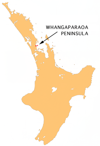
The Whangaparāoa Peninsula is a suburban area about 30–50 km north of Auckland, New Zealand. It had 33,390 residents in 2018. It stretches from Red Beach, where it connects to Kingsway, Orewa and Silverdale, and extends to Army Bay in the Hauraki Gulf. It is part of the Hibiscus Coast. The area is populated by residents who work on the peninsula, or commute from the area to other parts of the Hibiscus Coast, the North Shore, Rodney district, Auckland CBD and beyond for work. They travel by vehicle, or via the Gulf Harbour ferry at Gulf Harbour Marina, or the Hibiscus Coast Bus Station at Silverdale. There is one main road along its entire length, which is accessible from State Highway 1 via Hibiscus Coast Highway at Silverdale, or from Hibiscus Coast Highway at Orewa via Red Beach. It is popular as a tourist destination for catching a ferry to Tiritiri Matangi Island, and for visiting Shakespear Regional Park. It has one open (Whangaparāoa Golf Club) and one closed golf club (Gulf Harbour Country Club), beaches, sporting and recreation facilities, a library, shops, businesses and public and private primary and secondary schools. The median age of the population is in the 30s-40s.

Gulf St Vincent, sometimes referred to as St Vincent Gulf, St Vincent's Gulf or Gulf of St Vincent, is the eastern of two large inlets of water on the southern coast of Australia, in the state of South Australia, the other being the larger Spencer Gulf, from which it is separated by Yorke Peninsula. On its eastern side the gulf is bordered by the Adelaide Plains and the Fleurieu Peninsula.

The Yorke Peninsula, known as Guuranda by the original inhabitants, the Narungga people, is a peninsula located northwest and west of Adelaide in South Australia, between Spencer Gulf on the west and Gulf St Vincent on the east. The peninsula is separated from Kangaroo Island to the south by Investigator Strait.
Al-Fāw is a port town on Al-Faw Peninsula in Iraq near the Shatt al-Arab and the Persian Gulf. The Al Faw Peninsula is part of the Basra Governorate.

The Gulf of Boothia is a body of water in Nunavut, Canada. Administratively it is divided between the Kitikmeot Region on the west and the Qikiqtaaluk Region on the east. It merges north into Prince Regent Inlet, the two forming a single bay with different names for its parts. It is surrounded by, clockwise, Baffin Island, Fury and Hecla Strait, the Melville Peninsula, the Canadian mainland, and the Boothia Peninsula. The south end is Committee Bay, northwest of which are the Simpson Peninsula and Pelly Bay. On the west side of the gulf at 70°18′N91°42′W, north of Pelly Bay and Thom Bay, is Eden Bay, which should not be confused with a bay of the same name in the Qikiqtaaluk Region.
The Peninsula Shield Force is the military arm of the Gulf Cooperation Council (GCC). It is intended to deter, and respond to military aggression against any of the GCC member countries: Bahrain, Kuwait, Oman, Saudi Arabia, Qatar, and the United Arab Emirates.