
Burkittsville is a historic village in Frederick County, Maryland, United States. The village lies in the southern Middletown Valley along the eastern base of South Mountain.
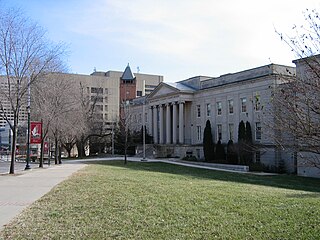
The Montgomery County Circuit Courthouses are part of the Montgomery County Judicial Center located in downtown Rockville, Maryland. The Red Brick Courthouse, located at 29 Courthouse Square, houses the refurbished Grand Courtroom; the newer Circuit Court building, located at 50 Maryland Avenue, houses the remainder of the county's justice system.

The Airview Historic District is a district of 12 houses built between 1896 and 1930 on each side of East Main Street in Middletown, Maryland. The district was developed to take advantage of the Hagerstown and Frederick Railway, which paralleled what was then known as the National Pike, and is an example of a small-scale streetcar suburb. The subdivision was subdivided from the Kefauver farm and included a trolley stop in front of developer Lewis Kefauver's house. The trolley right-of-way is still visible in the deep setback between the street and the sidewalk in the front yards of houses on the north side of the street.

The Buckeystown Historic District includes the majority of the small town of Buckeystown, Maryland, an unincorporated community located in Frederick County, Maryland, USA. It is named for George Buckey, a tanner, and his brother, John Buckey, a blacksmith and tavern owner. Buckeystown is on the U.S National Register of Historic Places and the Maryland Civil War Trail due to its rich history and beautiful examples of Queen Anne and Victorian style houses, along with a small commercial center. Each historic home has a plaque indicating the year built, the earliest being circa 1780. There are also several historical information plaques installed along the main street.
Strawberry Hill is a Georgian style farmhouse near Thurmont, Frederick County, Maryland, built in 1783. The house is substantially similar in plan to nearby Pennterra, but lacks Pennterra's later Victorian additions. The locally quarried stone includes an unusual diamond pattern on the southeast side of the house.

The Garrett Park Historic District is a national historic district located at Garrett Park, Montgomery County, Maryland. It's a 154-acre (62 ha) residential community incorporated in 1891, along the B & O Railroad. The older community includes a number of late Victorian homes. During the 1920s, the town expanded with a set of 40,640-square-foot (3,776 m2), "Chevy" houses built by Maddux, Marshall & Co. The district also includes a set of Prairie Style homes designed and built by Alexander Richter during the 1950s.

The Inns on the National Road is a national historic district near Cumberland, Allegany County, Maryland. It originally consisted of 11 Maryland inns on the National Road and located in Allegany and Garrett counties. Those that remain stand as the physical remains of the almost-legendary hospitality offered on this well-traveled route to the west.

Mountain Lake Park Historic District is a national historic district in Mountain Lake Park, Garrett County, Maryland. It consists of a group of 145 buildings lying within the town, which was launched in the 1880s as a summer resort and important as a center of the Chautauqua movement in Maryland. The district still includes many of the houses built by summer residents of town in the late 19th and early 20th centuries, built in various interpretations of the "Country Gothic" or Rural Queen Anne styles. Also within the district are several of the educational and recreational buildings constructed by the Mountain Lake Park Association, the Methodist-led group which owned and managed the town for many years after its founding in 1881.

The Emmitsburg Historic District is a national historic district in Emmitsburg, Frederick County, Maryland. The district is predominantly residential and includes most of the older area of the town extending along Main Street and Seton Avenue. Also included are several commercial buildings and churches interspersed among the dwellings. The buildings are primarily two-story sided log or brick, dating from the late 18th to the mid 19th centuries. Some later 19th century buildings in this area include some large Italianate-influenced buildings forming the northeast and southeast corners of the main square; an area destroyed by fire in 1863. Settlement began in the region during the 1730s, bringing Protestant Germans and Scotch-Irish from Pennsylvania, as well as English Catholics from Tidewater Maryland.
The Frederick Historic District is a national historic district in Frederick, Maryland. The district encompasses the core of the city and contains a variety of residential, commercial, ecclesiastical, and industrial buildings dating from the late 18th century to 1941. Notable are larger detached dwellings in the Queen Anne and American Foursquare architectural styles of the late 19th and early 20th centuries The churches reflect high style architecture ranging from Gothic and Greek Revival to Richardsonian Romanesque and Colonial Revival. The east side of the district includes the industrial buildings.

The New Market Historic District is a national historic district in New Market, Frederick County, Maryland. The district encompasses the town located along what was originally the National Pike. About 90 percent of the buildings in the historic district date from the 19th century and include Federal-style buildings and Greek Revival buildings, with a number of Victorian buildings, a larger example being the Ramsburg House.

The Mount Airy Historic District is a national historic district in Mount Airy, located in Carroll and Frederick County, Maryland. The district comprises a cohesive group of commercial, residential, and ecclesiastical buildings dating from the late 19th through early 20th centuries. The brick Baltimore and Ohio Railroad station, designed by E. Francis Baldwin and constructed in 1882, represents the town's origin as an early transportation center for the region, which dates back as early as 1838. A group of early-20th century commercial structures represent the rebuilding of Mount Airy's downtown after a series of fires between 1903 and 1926. The residential areas are characterized by houses illustrating vernacular forms and popular stylistic influences of the late 19th and early 20th century. Three churches are located within the district.
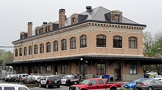
Hagerstown station is a historic railway station in Hagerstown, Washington County, Maryland. It was built in 1913 as a stop for the Western Maryland Railway. It is a 2+1⁄2-story hip roof brick building, reflecting the influence of the Commercial Style of the early 20th century. The building features overscaled classical detailing, a stone foundation, and a massive, modillioned cornice with stone disks defining each bay. The building is also encircled by a one-story porch that has a cantilevered roof on three sides.

Creagerstown is an unincorporated community in Frederick County, Maryland, United States. It is playfully known by its residents as "4 miles from everywhere" because of its situation at 4 miles (6.4 km) from Thurmont, Woodsboro, Rocky Ridge, and Lewistown.

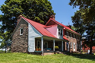
Johnsville is an unincorporated community in Frederick County, Maryland, United States. It is located approximately halfway between Libertytown and Union Bridge along Maryland Route 75. The Kitterman-Buckey Farm was listed on the National Register of Historic Places in 2005.

Central Catonsville and Summit Park Historic District is a national historic district in Catonsville, Baltimore County, Maryland, United States. It is entirely residential and consists generally of rectangular lots, the largest lots being found on Frederick Road and Newburg Avenue. These contain the earliest dwellings. The earliest, and the largest house in the district is the Gary Mansion, known as The Summit, built in the 1850s as a summer house in Second Empire style. The Summit Park subdivision takes its name from this house, and surrounds it on all sides. Structures in the district date from 1869 and extends to 1958, by which date the neighborhood had substantially achieved its present form and appearance.

Western Maryland College Historic District is a national historic district at Westminster, Carroll County, Maryland, United States. It is situated within the confines of the present 100-plus acre college campus of McDaniel College and comprises an area of about three acres at its southeast corner. It includes six of the college's earliest surviving buildings and structures: Alumni Hall, Carroll Hall, Levine Hall, The President's House, Little Baker Chapel, and the Ward Memorial Arch. These structures are the oldest surviving architectural links with the 19th century beginnings of the college.

Walton "Kip" Danforth Stowell was an American architect and historic preservationist, best known for his work for the U.S. National Park Service in designing visitors centers and interpretive exhibits in U.S. National Parks throughout the country. For most of his career, he worked at the Harpers Ferry Design Center which is responsible for architectural design and interpretive planning in National Parks.

The Crampton's Gap Historic District comprises the battlefield where the American Civil War Battle of Crampton's Gap, part of the larger Battle of South Mountain, took place on September 14, 1862. The district extends on the west to the foot of South Mountain, and to the east of Burkittsville, beyond the eastern foot of the mountain. The district is characterized by steep mountain terrain in the west and open farmland in the east, with the small town of Burkittsville in the center, which is itself listed as a historic district on the National Register of Historic Places. The district extends to the south to include Brownsville Gap. The district includes 98 contributing buildings, 78 of which are in the Burkittsville Historic District. Crampton's Gap at the crest of the mountain is encompassed by Gathland State Park, which features the War Correspondents Memorial Arch, erected in 1896 to memorialize journalists killed in wartime. The arch is listed on the National Register as part of Antietam National Battlefield. The mountainous portions of the district feature numerous stone walls, which were used by both sides for shelter against gunfire during the battle.
Petersville is an unincorporated community in Frederick County, Maryland, United States. Petersville is located at the junction of Maryland routes 79 and 180, 1.3 miles (2.1 km) northeast of Rosemont.


