
A flood is an overflow of water that submerges land that is usually dry. In the sense of "flowing water", the word may also be applied to the inflow of the tide. Floods are an area of study of the discipline hydrology and are of significant concern in agriculture, civil engineering and public health. Human changes to the environment often increase the intensity and frequency of flooding, for example land use changes such as deforestation and removal of wetlands, changes in waterway course or flood controls such as with levees, and larger environmental issues such as climate change and sea level rise. In particular climate change's increased rainfall and extreme weather events increases the severity of other causes for flooding, resulting in more intense floods and increased flood risk.

A natural disaster is the highly harmful impact on a society or community following a natural hazard event. Some examples of natural hazard events include: flooding, drought, earthquake, tropical cyclone, lightning, tsunami, volcanic activity, wildfire. A natural disaster can cause loss of life or damage property, and typically leaves economic damage in its wake. The severity of the damage depends on the affected population's resilience and on the infrastructure available. Scholars have been saying that the term natural disaster is unsuitable and should be abandoned. Instead, the simpler term disaster could be used, while also specifying the category of hazard. A disaster is a result of a natural or human-made hazard impacting a vulnerable community. It is the combination of the hazard along with exposure of a vulnerable society that results in a disaster.
A controlled or prescribed (Rx) burn, which can include hazard reduction burning, backfire, swailing or a burn-off, is a fire set intentionally for purposes of forest management, fire suppression, farming, prairie restoration or greenhouse gas abatement. A controlled burn may also refer to the intentional burning of slash and fuels through burn piles. Fire is a natural part of both forest and grassland ecology and controlled fire can be a tool for foresters.

A mudflow, also known as mudslide or mud flow, is a form of mass wasting involving fast-moving flow of debris and dirt that has become liquified by the addition of water. Such flows can move at speeds ranging from 3 meters/minute to 5 meters/second. Mudflows contain a significant proportion of clay, which makes them more fluid than debris flows, allowing them to travel farther and across lower slope angles. Both types of flow are generally mixtures of particles with a wide range of sizes, which typically become sorted by size upon deposition.
The United States Environmental Protection Agency (EPA) Storm Water Management Model (SWMM) is a dynamic rainfall–runoff–subsurface runoff simulation model used for single-event to long-term (continuous) simulation of the surface/subsurface hydrology quantity and quality from primarily urban/suburban areas.

Surface runoff is the unconfined flow of water over the ground surface, in contrast to channel runoff. It occurs when excess rainwater, stormwater, meltwater, or other sources, can no longer sufficiently rapidly infiltrate in the soil. This can occur when the soil is saturated by water to its full capacity, and the rain arrives more quickly than the soil can absorb it. Surface runoff often occurs because impervious areas do not allow water to soak into the ground. Furthermore, runoff can occur either through natural or human-made processes.

Debris flows are geological phenomena in which water-laden masses of soil and fragmented rock rush down mountainsides, funnel into stream channels, entrain objects in their paths, and form thick, muddy deposits on valley floors. They generally have bulk densities comparable to those of rock avalanches and other types of landslides, but owing to widespread sediment liquefaction caused by high pore-fluid pressures, they can flow almost as fluidly as water. Debris flows descending steep channels commonly attain speeds that surpass 10 m/s (36 km/h), although some large flows can reach speeds that are much greater. Debris flows with volumes ranging up to about 100,000 cubic meters occur frequently in mountainous regions worldwide. The largest prehistoric flows have had volumes exceeding 1 billion cubic meters. As a result of their high sediment concentrations and mobility, debris flows can be very destructive.
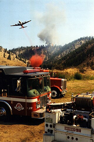
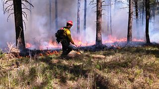
Wildfire suppression is a range of firefighting tactics used to suppress wildfires. Firefighting efforts depend on many factors such as the available fuel, the local atmospheric conditions, the features of the terrain, and the size of the wildfire. Because of this wildfire suppression in wild land areas usually requires different techniques, equipment, and training from the more familiar structure fire fighting found in populated areas. Working in conjunction with specially designed aerial firefighting aircraft, fire engines, tools, firefighting foams, fire retardants, and using various firefighting techniques, wildfire-trained crews work to suppress flames, construct fire lines, and extinguish flames and areas of heat in order to protect resources and natural wilderness. Wildfire suppression also addresses the issues of the wildland–urban interface, where populated areas border with wild land areas.

The Cerro Grande Fire was a prescribed forest fire in Los Alamos, New Mexico, United States of America, that occurred in May of 2000. The fire started as a controlled burn, and became uncontrolled owing to high winds and drought conditions. Over 400 families in the town of Los Alamos, New Mexico, lost their homes in the resulting 43,000-acre (170 km2) fire. Structures at Los Alamos National Laboratory were also destroyed or damaged, although without loss or destruction of any of the special nuclear material housed there. No loss of human life occurred. The US General Accounting Office estimated total damages at $1 billion.
The Dome Fire was a destructive wildfire in the Jemez Mountains in the northern region of the U.S. state of New Mexico during the 1996 fire season. It has been described by forester Bill Armstrong as "a wakeup call that nobody woke up to", anomalous at the time but an indicator of future high-intensity fires that are becoming more common due to both local and global environmental changes.
There have been known various classifications of landslides. Broad definitions include forms of mass movement that narrower definitions exclude. For example, the McGraw-Hill Encyclopedia of Science and Technology distinguishes the following types of landslides:

The McNally Fire was a massive wildfire in the Sequoia National Forest which burned 150,696 acres (609.8 km2) in July and August 2002, and the largest wildfire of the 2002 California wildfire season. The fire burned from July 21 to August 29, 2002, through the Sequoia and Inyo National Forest, as well as 5% of Giant Sequoia National Monument. It destroyed 14 structures and cost an estimated $45.7 million to put out. The blaze was started due to the "careless use of fire" near the Roads End Resort in Kern Canyon, and spread east through the canyon and threatened the communities of Johnsondale and Ponderosa. It burned within one mile (1.6 km) of the Packsaddle Grove of giant sequoias.
Wildfires consume live and dead fuels, destabilize physical and ecological landscapes, and impact human social and economic systems. Post-fire seeding was initially used to stabilize soils. More recently it is being used to recover post wildfire plant species, manage invasive non-native plant populations and establish valued vegetation compositions.
The Water Erosion Prediction Project (WEPP) model is a physically based erosion simulation model built on the fundamentals of hydrology, plant science, hydraulics, and erosion mechanics. The model was developed by an interagency team of scientists to replace the Universal Soil Loss Equation (USLE) and has been widely used in the United States and the world. WEPP requires four inputs, i.e., climate, topography, soil, and management (vegetation); and provides various types of outputs, including water balance, soil detachment and deposition at points along the slope, sediment delivery, and vegetation growth. The WEPP model has been improved continuously since its public delivery in 1995, and is applicable for a variety of areas.

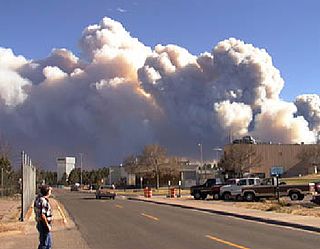
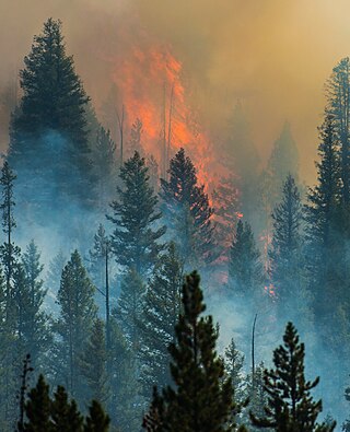
Wildfires are outdoor fires that occur in the wilderness or other vast spaces. Other common names associated with wildfires are brushfire and forest fire. Since wildfires can occur anywhere on the planet, except for Antarctica, they pose a threat to civilizations and wildlife alike. In terms of emergency management, wildfires can be particularly devastating. Given their ability to destroy large areas of entire ecosystems, there must be a contingency plan in effect to be as prepared as possible in case of a wildfire and to be adequately prepared to handle the aftermath of one as well.
The Beaver Creek Fire was a forest fire that began on August 7, 2013 after a lightning strike in an area twelve miles northeast of Fairfield, Idaho and northwest of Hailey, Idaho in Sawtooth National Forest. The fire burned through pine trees, sagebrush, timber in the understory, grass, and various riparian areas. The fire coated the resort areas of Hailey, Ketchum, and Sun Valley, in a layer of thick soot and ash. By the time the fire was fully contained on August 31, 114,900 acres of the Ketchum Ranger District of Sawtooth National Forest has been burned. Of the 114,900 acres burned, 57,000 acres were moderately damaged and 9,500 acres were severely damaged.
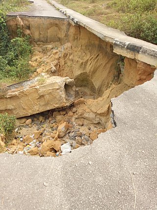
The Nigerian gully erosion crisis has been underway since before 1980. It is an ecological, environmental, economic, and humanitarian disaster resulting in land degradation, as well as the loss of lives and properties worth millions of dollars. The estimated number of gullies in the country is at 3,000.

The Chetco Bar Fire was a wildfire in the Kalmiopsis Wilderness, Oregon, United States. The fire, which was caused by a lightning strike and first reported on July 12, 2017. It burned 191,125 acres (773 km2) as of November 4, when it was declared 100% contained. The Chetco Bar Fire area is subject to warm, dry winds known as the Brookings effect, driven by high pressure over the Great Basin. The fire re-burned portions of the 2002 Biscuit Fire and the 1987 Silver Fire. The fire directly impacted communities surrounding it, causing mandatory evacuations.

A series of mudflows occurred in Southern California in early January 2018, particularly affecting areas northwest of Montecito in Santa Barbara County. The incident was responsible for 23 deaths, although the body of one of the victims has never been found. Approximately 163 people were hospitalized with various injuries, including four in critical condition. The disaster occurred one month after a series of major wildfires. The conflagrations devastated steep slopes, which caused loss of vegetation and destabilization of the soil and greatly facilitated subsequent mudflows. The mudflows caused at least $177 million in property damage, and cost at least $7 million in emergency responses and another $43 million to clean up.
Post-fire hillslope stabilization treatments are treatments aimed at stabilizing fire-affected slopes by counteracting the negative impact of fire on vegetation and soil properties. The final objective of these treatments is reducing the risk of catastrophic runoff and erosion events and protecting valued resources downhill. Post-fire hillslope stabilization treatments are also called post-fire mitigation treatments and emergency stabilization treatments.


