Burnt Hill, New Zealand

Last updated

Burnt Hill
New Zealand location map.svg
Disc Plain red.svg
Burnt Hill
Coordinates: 43°22′19″S172°08′49″E / 43.372°S 172.147°E / -43.372; 172.147 Coordinates: 43°22′19″S172°08′49″E / 43.372°S 172.147°E / -43.372; 172.147
Country Flag of New Zealand.svg  New Zealand
Region Canterbury
Territorial authority Waimakariri District
ElectoratesWaimakariri
Te Tai Tonga (Maori electorate) [1]
Time zone UTC+12 (NZST)
  Summer (DST) UTC+13 (NZDT)
Postcode
7495
Area code(s) 03
Local iwi Ngāi Tahu

Burnt Hill is a small rural community in the Waimakariri District, New Zealand. It is named for the small extinct volcano [2] that resides in the township's south-east corner.

Waimakariri District Territorial authority in South Island, New Zealand

Waimakariri District is a local government district, located in the Canterbury region of New Zealand's South Island. It is named after the Waimakariri River, which forms the district's southern boundary, separating it from Christchurch City and the Selwyn District. It is bounded in the north by the Hurunui District and in the east by the Pacific Ocean.

New Zealand Country in Oceania

New Zealand is a sovereign island country in the southwestern Pacific Ocean. The country has two main landmasses—the North Island, and the South Island —and around 600 smaller islands. It has a total land area of 268,000 square kilometres (103,500 sq mi). New Zealand is about 2,000 kilometres (1,200 mi) east of Australia across the Tasman Sea and 1,000 kilometres (600 mi) south of the Pacific island areas of New Caledonia, Fiji, and Tonga. Because of its remoteness, it was one of the last lands to be settled by humans. During its long period of isolation, New Zealand developed a distinct biodiversity of animal, fungal, and plant life. The country's varied topography and its sharp mountain peaks, such as the Southern Alps, owe much to the tectonic uplift of land and volcanic eruptions. New Zealand's capital city is Wellington, and its most populous city is Auckland.

Climate

The average temperature in summer is 16.2 °C, and in winter is 5.9 °C. [3]

Summer one of the Earths four temperate seasons, occurring between spring and autumn

Summer is the hottest of the four temperate seasons, falling after spring and before autumn. At the summer solstice, the days are longest and the nights are shortest, with day length decreasing as the season progresses after the solstice. The date of the beginning of summer varies according to climate, tradition, and culture. When it is summer in the Northern Hemisphere, it is winter in the Southern Hemisphere, and vice versa.

Winter one of the Earths four temperate seasons, occurring between autumn and spring

Winter is the coldest season of the year in polar and temperate zones. It occurs after autumn and before spring in each year. Winter is caused by the axis of the Earth in that hemisphere being oriented away from the Sun. Different cultures define different dates as the start of winter, and some use a definition based on weather. When it is winter in the Northern Hemisphere, it is summer in the Southern Hemisphere, and vice versa. In many regions, winter is associated with snow and freezing temperatures. The moment of winter solstice is when the Sun's elevation with respect to the North or South Pole is at its most negative value. The day on which this occurs has the shortest day and the longest night, with day length increasing and night length decreasing as the season progresses after the solstice. The earliest sunset and latest sunrise dates outside the polar regions differ from the date of the winter solstice, however, and these depend on latitude, due to the variation in the solar day throughout the year caused by the Earth's elliptical orbit.

MonthNormal temperature
January16.8 °C
February16.3 °C
March14.6 °C
April11.6 °C
May8.3 °C
June5.8 °C
July5.3 °C
August6.5 °C
September8.9 °C
October11.2 °C
November13.3 °C
December15.5 °C

Related Research Articles

Wellington Capital city of New Zealand

Wellington is the capital and second most populous urban area of New Zealand, with 418,500 residents. It is located at the south-western tip of the North Island, between Cook Strait and the Remutaka Range. Wellington is the major population centre of the southern North Island, and is the administrative centre of the Wellington Region, which also includes the Kapiti Coast and the Wairarapa. It is the world's southernmost capital of a sovereign state. Wellington features a temperate maritime climate, and is the world's windiest city by average wind speed.

Nelson, New Zealand City in Nelson City, New Zealand

Nelson is a city on the eastern shores of Tasman Bay. Nelson is the oldest city in the South Island and the second-oldest settled city in New Zealand – it was established in 1841 and was proclaimed a city by royal charter in 1858.

Queenstown, New Zealand Resort town in Otago, New Zealand

Queenstown is a resort town in Otago in the south-west of New Zealand's South Island. It has an urban population of 15,850, making it the 27th-largest urban area in New Zealand. In 2016, Queenstown overtook Oamaru to become the second-largest urban area in Otago, behind Dunedin.

Guilin Prefecture-level city in Guangxi, Peoples Republic of China

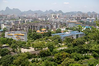
Guilin,, is a prefecture-level city in the northeast of China's Guangxi Zhuang Autonomous Region. It is situated on the west bank of the Li River and borders Hunan to the north. Its name means "Forest of Sweet Osmanthus", owing to the large number of fragrant sweet osmanthus trees located in the region. The city has long been renowned for its scenery of karst topography.

Fokker F27 Friendship Regional airliner by Fokker

The Fokker F27 Friendship is a turboprop airliner developed and manufactured by the Dutch aircraft manufacturer Fokker. It has the distinction of being the most numerous post-war aircraft to have been manufactured in the Netherlands; the F27 was also one of the most successful European airliners of its era.

United Future New Zealand political party

United Future New Zealand, usually known as United Future, was a centrist political party in New Zealand. The party was in government between 2005 and 2017, first alongside Labour (2005–2008) and then supporting National (2008–2017).

Dunedin City in Otago, New Zealand

Dunedin is the second-largest city in the South Island of New Zealand, and the principal city of the Otago region. Its name comes from Dùn Èideann, the Scottish Gaelic name for Edinburgh, the capital of Scotland.

Christchurch City in South Island, New Zealand

Christchurch is the largest city in the South Island of New Zealand and the seat of the Canterbury Region. The Christchurch urban area lies on the South Island's east coast, just north of Banks Peninsula. It is home to 404,500 residents, making it New Zealand's third-most populous city behind Auckland and Wellington. The Avon River flows through the centre of the city, with an urban park located along its banks.

Burnt Oak suburb in the Edgware district of North London, in the London Borough of Barnet, London, England

Burnt Oak is a suburb in the Edgware district in northwest London, England. It is within the London Borough of Barnet and the London Borough of Brent and was a part of Middlesex until it got transferred to Greater London in 1965.

Tui (bird) species of bird

The tui is an endemic passerine bird of New Zealand, and the only species in the genus Prosthemadera. It is one of the largest species in the diverse Australasian honeyeater family (Meliphagidae), and one of two living species of that family found in New Zealand, the other being the New Zealand bellbird. The tui has a wide distribution in the archipelago, ranging from the subtropical Kermadec Islands to the sub-Antarctic Auckland Islands, as well as the main islands.

Crook, County Durham town in County Durham, England

Crook is a historic market town in County Durham, in the North East of England.

Wellington International Airport airport in Rongotai, New Zealand

Wellington International Airport is an international airport located in the suburb of Rongotai in Wellington, the capital city of New Zealand. It lies 3 NM or 5.5 km south-east from the city centre. It is a hub for Air New Zealand and its subsidiaries. Wellington International Airport Limited, a joint venture between Infratil and the Wellington City Council, operates the airport.

Van Asch College State, co-educational special school

Van Asch Deaf Education Centre is located in Truro Street, Sumner, Christchurch, New Zealand. It is a special school for deaf children, accepting both day and residential pupils, as well being as a resource centre providing services and support for parents, mainstream students and their teachers in the South Island and the Lower North Island.

Stotfold town in Central Bedfordshire, United Kindom

Stotfold is a small town and civil parish in Bedfordshire, England.

Southland, New Zealand Region of New Zealand in South Island

Southland is New Zealand's southernmost region. It consists mainly of the southwestern portion of the South Island and Stewart Island / Rakiura. It includes Southland District, Gore District and the city of Invercargill. The region covers over 3.1 million hectares and spans over 3,400 km of coast.

Australian Capital Territory Rural Fire Service

The ACT Rural Fire Service is a branch of the Australian Capital Territory Emergency Services Agency. It is responsible for the prevention, detection and extinguishment of all bushfires within the ACT, as well as assisting the other branches of ESA.

Coopers Creek, New Zealand Rural Area in Canterbury, New Zealand

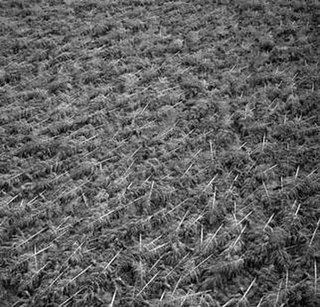
Coopers Creek is a small rural community near Oxford, New Zealand in the Waimakariri District, New Zealand. It has only eight roads, and no shops. It has a number of mountains and walking tracks. In 1901, Coopers Creek had a population of 168.

Eyrewell Forest Rural Area in Canterbury, New Zealand

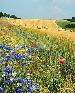
Eyrewell Forest is a small rural area in the Waimakariri District, New Zealand.

References

  1. "Archived copy". Archived from the original on 8 February 2013. Retrieved 27 November 2013.CS1 maint: archived copy as title (link)
  2. "Te Ara - PEARSON, Joseph" . Retrieved 27 November 2013.
  3. "Weather statistics for Burnt Hill, Canterbury (New Zealand)". yr.no. Retrieved 27 November 2013.