
Upper Hutt is a city in the Wellington Region of the North Island of New Zealand, and one of the four cities that constitute the Wellington metropolitan area.

Cheviot is a town in the Hurunui District of north Canterbury, on the east coast of the South Island of New Zealand. It is on State Highway 1 approximately 110 kilometres (68 mi) north of Christchurch.
Lincoln is a town in the Selwyn District, in the Canterbury Region of New Zealand's South Island. The town is located on the Canterbury Plains to the west of Banks Peninsula, 22 kilometres southwest of Christchurch. The town has a population of 6,030, making it the second largest town in the Selwyn District behind nearby Rolleston.

Kaiapoi is a town in the Waimakariri District of the Canterbury region, in the South Island of New Zealand. The town is located approximately 17 kilometres north of central Christchurch, close to the mouth of the Waimakariri River. It is considered to be a satellite town of Christchurch, although in the Waimakariri for statistical purposes it is part of the Christchurch urban area.

Westport is a town in the West Coast region of the South Island of New Zealand. It is on the northern bank and at the mouth of the Buller River, close by the prominent headland of Cape Foulwind. It is connected via State Highway 6 with Greymouth, 100 kilometres (62 mi) to the south, and with Nelson 222 kilometres (138 mi) in the northeast, via the Buller Gorge.

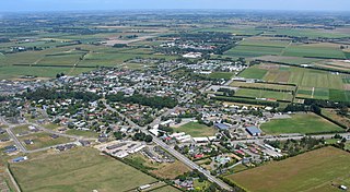
Rangiora is the largest town and seat of the Waimakariri District, in Canterbury, New Zealand. It is 29 kilometres (18 mi) north of Christchurch, and is considered a satellite town of the city. With a population of 18,400, Rangiora is the 29th largest urban area in New Zealand, and the fourth-largest in the Canterbury region.

The Waimakariri River is one of the largest rivers in Canterbury, on the eastern coast of New Zealand's South Island. It flows for 151 kilometres (94 mi) in a generally southeastward direction from the Southern Alps across the Canterbury Plains to the Pacific Ocean.

Waipawa is the second-largest town in Central Hawke's Bay in the east of the North Island of New Zealand. It has a population of 2,170. At the 2013 census, it had a population of 1,965, a change of 2.2 percent from the 2006 census.

Silverstream is a suburb of Upper Hutt, just under 7 km from the Upper Hutt CBD. It is in the lower North Island of New Zealand at the southern end of the city, close to the Taitā Gorge, which separates Upper Hutt from Lower Hutt. The area is sited at the mouth of a small valley formed by the Wellington Region's notable tectonic activity and, in part, by Hull's Creek, which discharges into the Hutt River.

Oxford is a small town of around 2,100 people serving the farming community of North Canterbury, New Zealand. It is part of the Waimakariri District and is a linear town, approximately 2 kilometres (1.2 mi) long. Originally, it was served by the Oxford Branch railway, and had two stations, East Oxford and West Oxford. The line closed in 1959 and was dismantled. Some railway signs and the remnants of railway platforms can still be seen along Oxford Road on the way to Rangiora.

Waimakariri District is a local government district, located in the Canterbury region of New Zealand's South Island. It is named after the Waimakariri River, which forms the district's southern boundary, separating it from Christchurch City and the Selwyn District. It is bounded in the north by the Hurunui District and in the east by the Pacific Ocean.

St Patrick's College is a state-integrated Catholic boys' day and boarding Secondary School located in Silverstream, Upper Hutt, New Zealand. It was established by the Society of Mary (Marists) in 1931 when the original St Patrick's College, Wellington was intended to be moved to a larger site more suited to a boarding school. In fact, both colleges survived. Today, they share not only a common history, motto and spirit but also a good natured rivalry and competition in many endeavours. Silverstreamers refer to the mother school simply as 'Town'.

Fernside is a small rural community in the Waimakariri District, New Zealand. In 1901, Fernside had a population of 550. As of the 2006 New Zealand census, Fernside has a population of 1491.

Woodend is a town in the Waimakariri District, in the Canterbury Region of the South Island of New Zealand. It may have been named because it was on the edge of what was then called the Maori Bush, or after an early settler, Thomas Wooding. It is situated with both the Waimakariri and Ashley Rivers running either side.

Cust is a rural village in the South Island of New Zealand. It is located in North Canterbury and comes under seat of the Waimakariri District Council. It is located approximately 16 km east of Oxford and 17 km west of Rangiora. The town is named after Sir Edward Cust, who was a member of the Canterbury Association which organised European settlement of the area around 1850. Earlier names for the town were Moeraki Downs and Middleton-on-the-Cust.

Ashley is a small town in North Canterbury, in the South Island of New Zealand. It used to have a railway station on the Main North Line that runs through the village. As of the 2013 New Zealand census, 1083 people live in Ashley.

Kaiapoi High School is a state co-educational secondary school located in Kaiapoi, in the Waimakariri District of New Zealand's South Island. The school serves 897 students from Years 9 to 13 as of March 2020.
Kairaki is a small rural community in the Waimakariri District, New Zealand. As of the 2006 New Zealand census, Kairaki has a population of 225.

Sefton is a small town in the Waimakariri District, New Zealand, about 23 miles from Christchurch.
Tauwhare is a small rural community in the Waikato District on the outskirts of Hamilton. The Waitakaruru Arboretum and Sculpture Park is located here.
