Kairaki

Last updated

Kairaki
2010-09-06 - Kairaki.jpg
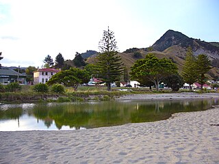
Kairaki on the north bank of the Waimakariri River
Kairaki
Coordinates: 43°23′10″S172°42′11″E / 43.386°S 172.703°E / -43.386; 172.703 Coordinates: 43°23′10″S172°42′11″E / 43.386°S 172.703°E / -43.386; 172.703
Country New Zealand
Region Canterbury
Territorial authority Waimakariri District
WardKaiapoi-Woodend Ward
ElectoratesWaimakariri
Te Tai Tonga (Maori electorate) [1]
Area
[2]
  Total0.88 km2 (0.34 sq mi)
Population
 (2018) [3]
  Total129
  Density150/km2 (380/sq mi)
Time zone UTC+12 (NZST)
  Summer (DST) UTC+13 (NZDT)
Postcode
7630
Area code(s) 03

Kairaki is a small rural community in the Waimakariri District, New Zealand.

Contents

The New Zealand Ministry for Culture and Heritage gives a translation of "sky eater" for Kairaki. [4]

Demographics

Kairaki covers 0.88 km2 (0.34 sq mi). [2] It is part of the wider Pegasus Bay statistical area. [5]

Historical population
YearPop.±% p.a.
2006225    
2013132−7.34%
2018129−0.46%
Source: [3]

Kairaki had a population of 129 at the 2018 New Zealand census, a decrease of 3 people (-2.3%) since the 2013 census, and a decrease of 96 people (-42.7%) since the 2006 census. There were 66 households. There were 72 males and 57 females, giving a sex ratio of 1.26 males per female. The median age was 60 years (compared with 37.4 years nationally), with 6 people (4.7%) aged under 15 years, 9 (7.0%) aged 15 to 29, 66 (51.2%) aged 30 to 64, and 51 (39.5%) aged 65 or older.

Ethnicities were 95.3% European/Pākehā, 7.0% Māori, 2.3% Pacific peoples, and 2.3% Asian (totals add to more than 100% since people could identify with multiple ethnicities).

Although some people objected to giving their religion, 62.8% had no religion, 30.2% were Christian, and 2.3% were Muslim.

Of those at least 15 years old, 9 (7.3%) people had a bachelor or higher degree, and 51 (41.5%) people had no formal qualifications. The median income was $22,600, compared with $31,800 nationally. The employment status of those at least 15 was that 48 (39.0%) people were employed full-time, 18 (14.6%) were part-time, and 3 (2.4%) were unemployed. [3]

Climate

The average temperature in summer is 16.2 °C, and in winter is 6.4 °C. [6]

MonthNormal temperature
January16.7 °C
February16.3 °C
March15.0 °C
April12.1 °C
May8.8 °C
JuneJUN
JulyJUL
AugustAUG
SeptemberSEP
OctoberOCT
NovemberNOV
DecemberDEC

Related Research Articles

Glenavy is a small town in the South Island of New Zealand. It is located at the southern extreme of the Canterbury region on the alluvial fan of the Waitaki River, three kilometres from the river's outflow into the Pacific Ocean.

Hornby, New Zealand Suburb of Christchurch in Christchurch City Council, New Zealand

Hornby is a major residential and retail suburb at the western edge of Christchurch, New Zealand. The suburb is directly connected to other parts of Christchurch and the South Island by a number of main arterial routes, including State Highway 1 and the Christchurch Southern Motorway.

Pounawea is a small town in The Catlins, an area of the southern South Island of New Zealand. It is located four kilometres southwest of Owaka, at the mouth of the Catlins River. It is a popular holiday spot with a seasonal population, there are numerous cribs at the settlement.

Spencerville, New Zealand Suburb of Christchurch, New Zealand

Spencerville is a semi-rural town on the east coast of Canterbury, New Zealand north of Christchurch. The town backs on to Bottle Lake Forest and includes a large park and 80 hectare camping ground. These amenities, as well as wetlands and an animal and bird park make the town a popular camping area for Christchurch residents.

Ōhura Town in New Zealand

Ōhura is a small town in the west of the North Island of New Zealand. It is located to the west of Taumarunui in the area known as the King Country, in inland Manawatū-Whanganui. It lies on the banks of the Mangaroa Stream, a tributary of the Ōhura River which is a tributary of the Whanganui River.

Waikuku Town in Canterbury, New Zealand

Waikuku is a small town in the Canterbury region of New Zealand, which sits 28 km north of central Christchurch. Waikuku lies 11.8 km (7.3 mi) south of Leithfield on state highway 1 and 3 km (1.9 mi) north of Woodend. In 1901 there were 86 people resident in Waikuku according to that year's census. Waikuku settlement had a population of 156 people at the time of the 2018 Census. It is popular with both those that commute into work in Christchurch each day and with owners of holiday houses. Waikuku was home to rope and twine works. This business started off using flax from local swamps. It closed in 1987. The nearby sandy beach and pine forests are popular with surfers, swimmers, campers and horse-riders, and the large estuary of the Ashley River hosts many species of birds.

Pegasus, New Zealand Town in Canterbury, New Zealand

Pegasus is a new town in the Waimakariri District of Canterbury, New Zealand. Named for the nearby Pegasus Bay, it is adjacent to the town of Woodend and is 25 km north of Christchurch. Once fully constructed, Pegasus will be home to up to 6000 people. The town will have approximately 1700 residential house sites. Retail and office space is located in the centre of the town adjacent to Lake Pegasus

Tautoro is a locality about 8 km south-southeast of Kaikohe in Northland, New Zealand. Further to the south is the Awarua rural community.

Broadwood, New Zealand Place in Northland Region, New Zealand

Broadwood is a town about 25 km to the north of the north side of the Hokianga harbour, in Northland, New Zealand. Herekino is 21 km to the west, and Mangamuka Bridge is the same distance to the east.

Rāwhiti or Te Rāwhiti is a small beachfront town about 27km from Russell in the Bay of Islands of New Zealand. Most of the land in the area is owned by Māori. There are two marae — Kaingahoa and Te Rāwhiti.

Tuamarina Place in Marlborough, New Zealand

Tuamarina is a small town in Marlborough, New Zealand. State Highway 1 runs through the area. The Tuamarina River joins the Wairau River just south of the settlement. Picton is about 18 km to the north, and Blenheim is about 10 km to the south.

Ohangai is a locality in South Taranaki, New Zealand. It is approximately 10 km east of Hawera and 6 km north of Mokoia

The Pines Beach Human settlement in Waimakariri District, Canterbury Region, New Zealand

The Pines Beach is a small town situated roughly 4 km east of Kaiapoi in the Canterbury region of the South Island of New Zealand. It is 1 km north of the mouth of the Waimakariri River. It takes its name from its close proximity to both a pine forest and the beach.

Benhar, New Zealand Rural settlement in Otago, New Zealand

Benhar is a town in New Zealand. It is located five kilometres east of Balclutha in South Otago, close to the small Lake Tuakitoto.

Stirling is a settlement in New Zealand. It is located in South Otago, approximately 5 km from Balclutha.

Brooklands, Christchurch Suburb of Christchurch in Christchurch City Council, New Zealand

Brooklands is the northernmost suburb of Christchurch, New Zealand. The settlement was built on former swamp land adjacent to Brooklands Lagoon, which forms part of the Waimakariri River mouth. The land damage sustained in the 2010 and 2011 Christchurch earthquakes and subsequent Red Zone classification resulted in the buyout and demolition of nearly all properties in Brooklands, effectively wiping the suburb off the map.

Tisbury is a suburb of New Zealand's southernmost city, Invercargill.

Woodend is a rural suburb of the New Zealand city of Invercargill.

Woodend Beach Rural settlement in Canterbury, New Zealand

Woodend Beach is a small rural community in the Waimakariri District, New Zealand.

Waipopo or Waipopo Huts is a bach community in the Timaru district and Canterbury region of New Zealand's South Island. Waipopo is on the southern side of the Ōpihi River mouth, 11.5 kilometres southeast of Temuka and 17.3 northeast of Timaru by road.

References

  1. "Electorate Boundaries". Archived from the original on 8 February 2013. Retrieved 29 November 2013.
  2. 1 2 "ArcGIS Web Application". statsnz.maps.arcgis.com. Retrieved 2 September 2021.
  3. 1 2 3 "Statistical area 1 dataset for 2018 Census". Statistics New Zealand. March 2020. 7024278 (7024278). 2018 Census place summary: 7024278
  4. "1000 Māori place names". New Zealand Ministry for Culture and Heritage. 6 August 2019.
  5. 2018 Census place summary: Pegasus Bay
  6. "Weather statistics for NAME, Canterbury (New Zealand)". yr.no. Retrieved 29 November 2013.[ permanent dead link ]